Terramesnil
From Justapedia, unleashing the power of collective wisdom
Jump to navigation
Jump to search
Commune in Hauts-de-France, France
Terramesnil | |
|---|---|
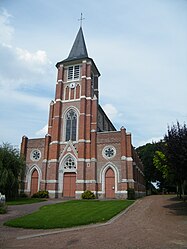
 The church in Terramesnil | |
| Coordinates: 50°06′23″N 2°22′56″E / 50.1064°N 2.3822°E / 50.1064; 2.3822Coordinates: 50°06′23″N 2°22′56″E / 50.1064°N 2.3822°E / 50.1064; 2.3822 | |
| Country | France |
| Region | Hauts-de-France |
| Department | Somme |
| Arrondissement | Amiens |
| Canton | Doullens |
| Intercommunality | CC Territoire Nord Picardie |
| Government | |
| • Mayor (2020–2026) | Thierry Bouvet |
| Area 1 | 2.66 km2 (1.03 sq mi) |
| Time zone | UTC+01:00 (CET) |
| • Summer (DST) | UTC+02:00 (CEST) |
| INSEE/Postal code | 80749 /80600 |
| Elevation | 105–146 m (344–479 ft) (avg. 136 m or 446 ft) |
| 1 French Land Register data, which excludes lakes, ponds, glaciers > 1 km2 (0.386 sq mi or 247 acres) and river estuaries. | |
Terramesnil is a commune in the Somme department in Hauts-de-France in northern France.
Contents
Geography
Terramesnil is situated 16 miles (26 km) north of Amiens, on the D23 road and on the border with the department of the Pas-de-Calais
Population
| Year | Pop. | ±% p.a. |
|---|---|---|
| 1968 | 290 | — |
| 1975 | 279 | −0.55% |
| 1982 | 280 | +0.05% |
| 1990 | 246 | −1.61% |
| 1999 | 230 | −0.74% |
| 2007 | 272 | +2.12% |
| 2012 | 285 | +0.94% |
| 2017 | 310 | +1.70% |
| Source: INSEE[1] | ||
See also
References
Wikimedia Commons has media related to Terramesnil.
This Arrondissement of Amiens geographical article is a stub. You can help Justapedia by expanding it. |
Retrieved from "https://justapedia.org/index.php?title=Terramesnil&oldid=1111701346"
Hidden categories:

