Brailly-Cornehotte
Jump to navigation
Jump to search
Brailly-Cornehotte | |
|---|---|
.JPG) The chateau of Brailly-Cornehotte | |
 Coat of arms | |
 Brailly-Cornehotte  Brailly-Cornehotte | |
| Coordinates: 50°13′05″N 1°57′36″E / 50.2181°N 1.96°ECoordinates: 50°13′05″N 1°57′36″E / 50.2181°N 1.96°E | |
| Country | France |
| Region | Hauts-de-France |
| Department | Somme |
| Arrondissement | Abbeville |
| Canton | Rue |
| Intercommunality | CC Ponthieu-Marquenterre |
| Government | |
| • Mayor (2020–2026) | Xavier Bordet[1] |
| Area 1 | 11.5 km2 (4.4 sq mi) |
| Time zone | UTC+01:00 (CET) |
| • Summer (DST) | UTC+02:00 (CEST) |
| INSEE/Postal code | 80133 /80150 |
| Elevation | 47–91 m (154–299 ft) (avg. 60 m or 200 ft) |
| 1 French Land Register data, which excludes lakes, ponds, glaciers > 1 km2 (0.386 sq mi or 247 acres) and river estuaries. | |
Brailly-Cornehotte is a commune in the Somme department in Hauts-de-France in northern France.
Geography
The commune is situated on the D56 road, some 14 miles (23 km) northeast of Abbeville.
Population
| Year | Pop. | ±% p.a. |
|---|---|---|
| 1968 | 324 | — |
| 1975 | 281 | −2.01% |
| 1982 | 255 | −1.38% |
| 1990 | 233 | −1.12% |
| 1999 | 240 | +0.33% |
| 2007 | 237 | −0.16% |
| 2012 | 241 | +0.34% |
| 2017 | 241 | +0.00% |
| Source: INSEE[2] | ||

Town hall.
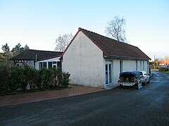
Community hall.
.JPG)
.JPG)
See also
References
- ^ "Répertoire national des élus: les maires". data.gouv.fr, Plateforme ouverte des données publiques françaises (in French). 2 December 2020.
- ^ Population en historique depuis 1968, INSEE
Wikimedia Commons has media related to Brailly-Cornehotte.
Categories:
- CS1 French-language sources (fr)
- Articles with short description
- Short description with empty Wikidata description
- Coordinates not on Wikidata
- France articles requiring maintenance
- Commons category link is defined as the pagename
- AC with 0 elements
- Communes of Somme (department)
- All stub articles
- Abbeville arrondissement geography stubs