Canchy, Somme
Jump to navigation
Jump to search
Canchy | |
|---|---|
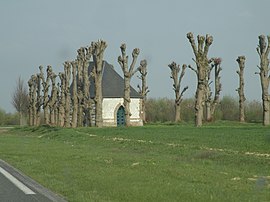
 The Chapel of Notre-Dame-de-Foy in Canchy | |
| Coordinates: 50°11′14″N 1°52′42″E / 50.1872°N 1.8783°ECoordinates: 50°11′14″N 1°52′42″E / 50.1872°N 1.8783°E | |
| Country | France |
| Region | Hauts-de-France |
| Department | Somme |
| Arrondissement | Abbeville |
| Canton | Abbeville-1 |
| Intercommunality | CC Ponthieu-Marquenterre |
| Government | |
| • Mayor (2020–2026) | Jean Grosbeau |
| Area 1 | 6.47 km2 (2.50 sq mi) |
| Time zone | UTC+01:00 (CET) |
| • Summer (DST) | UTC+02:00 (CEST) |
| INSEE/Postal code | 80167 /80150 |
| Elevation | 32–79 m (105–259 ft) (avg. 74 m or 243 ft) |
| 1 French Land Register data, which excludes lakes, ponds, glaciers > 1 km2 (0.386 sq mi or 247 acres) and river estuaries. | |
Canchy (French pronunciation: [kɑ̃ʃi] (![]() listen)) is a commune in the Somme department in Hauts-de-France in northern France.
listen)) is a commune in the Somme department in Hauts-de-France in northern France.
There was a station on the Réseau des Bains de Mer which opened on 19 June 1892 and closed on 10 March 1947.
Geography
Canchy is situated just off the D928 road (it now bypasses the town), some 5 miles (8 km) north of Abbeville.
Population
| Year | Pop. | ±% p.a. |
|---|---|---|
| 1968 | 380 | — |
| 1975 | 346 | −1.33% |
| 1982 | 327 | −0.80% |
| 1990 | 313 | −0.55% |
| 1999 | 307 | −0.21% |
| 2007 | 298 | −0.37% |
| 2012 | 314 | +1.05% |
| 2017 | 322 | +0.50% |
| Source: INSEE[1] | ||
See also
References
Wikimedia Commons has media related to Canchy (Somme).
Categories:
- Articles with short description
- Short description with empty Wikidata description
- Coordinates not on Wikidata
- France articles requiring maintenance
- Articles with hAudio microformats
- Commons category link is locally defined
- AC with 0 elements
- Communes of Somme (department)
- All stub articles
- Abbeville arrondissement geography stubs

