Brutelles
Jump to navigation
Jump to search
Brutelles | |
|---|---|
 The church in Brutelles | |
 Brutelles  Brutelles | |
| Coordinates: 50°08′30″N 1°31′21″E / 50.1417°N 1.5225°ECoordinates: 50°08′30″N 1°31′21″E / 50.1417°N 1.5225°E | |
| Country | France |
| Region | Hauts-de-France |
| Department | Somme |
| Arrondissement | Abbeville |
| Canton | Friville-Escarbotin |
| Intercommunality | CA Baie de Somme |
| Government | |
| • Mayor (2020–2026) | Françoise Maison[1] |
| Area 1 | 6.29 km2 (2.43 sq mi) |
| Time zone | UTC+01:00 (CET) |
| • Summer (DST) | UTC+02:00 (CEST) |
| INSEE/Postal code | 80146 /80230 |
| Elevation | 3–59 m (9.8–193.6 ft) (avg. 13 m or 43 ft) |
| 1 French Land Register data, which excludes lakes, ponds, glaciers > 1 km2 (0.386 sq mi or 247 acres) and river estuaries. | |
Brutelles (French pronunciation: [bʁytɛl]) is a commune in the Somme department in Hauts-de-France in northern France.
Geography
Brutelles is situated on the D940 road, some 11 miles (18 km) west of Abbeville.
Population
| Year | Pop. | ±% p.a. |
|---|---|---|
| 1968 | 189 | — |
| 1975 | 164 | −2.01% |
| 1982 | 183 | +1.58% |
| 1990 | 200 | +1.12% |
| 1999 | 179 | −1.23% |
| 2007 | 189 | +0.68% |
| 2012 | 184 | −0.53% |
| 2017 | 207 | +2.38% |
| Source: INSEE[2] | ||
Places of interest

Old postcard of Brutelles town square
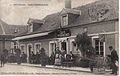
Old postcard of a Brutelles café

Old postcard of the school in Brutelles
Old postcard of Route de St Valery à Eu

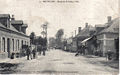
Church Street in Brutelles
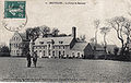
Old postcard of Beaumer Farm, between Hautebut and Brutelles
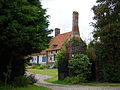
Recent photograph of the old farm at Hamel
,_la_place.jpg)


See also
References
- ^ "Répertoire national des élus: les maires". data.gouv.fr, Plateforme ouverte des données publiques françaises (in French). 2 December 2020.
- ^ Population en historique depuis 1968, INSEE
Wikimedia Commons has media related to Brutelles.
Categories:
- CS1 French-language sources (fr)
- Articles with short description
- Short description with empty Wikidata description
- Coordinates not on Wikidata
- France articles requiring maintenance
- Commons category link is defined as the pagename
- AC with 0 elements
- Communes of Somme (department)
- All stub articles
- Abbeville arrondissement geography stubs