Épaumesnil
From Justapedia, unleashing the power of collective wisdom
Jump to navigation
Jump to search
Commune in Hauts-de-France, FranceTemplate:SHORTDESC:Commune in Hauts-de-France, France
Épaumesnil | |
|---|---|
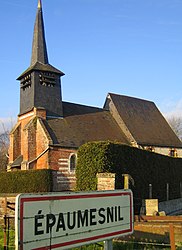
 The church | |
| Coordinates: 49°54′46″N 1°51′13″E / 49.9128°N 1.8536°E / 49.9128; 1.8536Coordinates: 49°54′46″N 1°51′13″E / 49.9128°N 1.8536°E / 49.9128; 1.8536 | |
| Country | France |
| Region | Hauts-de-France |
| Department | Somme |
| Arrondissement | Amiens |
| Canton | Poix-de-Picardie |
| Intercommunality | CC Somme Sud-Ouest |
| Government | |
| • Mayor (2020–2026) | André Simon |
| Area 1 | 4.74 km2 (1.83 sq mi) |
| Time zone | UTC+01:00 (CET) |
| • Summer (DST) | UTC+02:00 (CEST) |
| INSEE/Postal code | 80269 /80140 |
| Elevation | 68–129 m (223–423 ft) (avg. 60 m or 200 ft) |
| 1 French Land Register data, which excludes lakes, ponds, glaciers > 1 km2 (0.386 sq mi or 247 acres) and river estuaries. | |
Épaumesnil (French pronunciation: [epomɛnil]) is a commune in the Somme department in Hauts-de-France in northern France.
Contents
Geography
Épaumesnil is situated on the D96 road, some 37 km (23 mi) west of Amiens.
Population
| Year | Pop. | ±% p.a. |
|---|---|---|
| 1968 | 117 | — |
| 1975 | 119 | +0.24% |
| 1982 | 109 | −1.25% |
| 1990 | 119 | +1.10% |
| 1999 | 107 | −1.17% |
| 2007 | 116 | +1.01% |
| 2012 | 126 | +1.67% |
| 2017 | 133 | +1.09% |
| Source: INSEE[1] | ||
See also
References
Wikimedia Commons has media related to Épaumesnil.
This Arrondissement of Amiens geographical article is a stub. You can help Justapedia by expanding it. |
Retrieved from "https://justapedia.org/index.php?title=Épaumesnil&oldid=1112653526"

