Tubersent
Jump to navigation
Jump to search
Tubersent | |
|---|---|
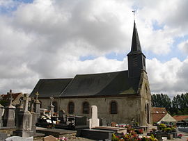
 The church of Tubersent | |
| Coordinates: 50°31′14″N 1°42′19″E / 50.5206°N 1.7053°ECoordinates: 50°31′14″N 1°42′19″E / 50.5206°N 1.7053°E | |
| Country | France |
| Region | Hauts-de-France |
| Department | Pas-de-Calais |
| Arrondissement | Montreuil |
| Canton | Étaples |
| Intercommunality | CA Deux Baies en Montreuillois |
| Government | |
| • Mayor (2020–2026) | Hubert Degreve |
| Area 1 | 6.9 km2 (2.7 sq mi) |
| Time zone | UTC+01:00 (CET) |
| • Summer (DST) | UTC+02:00 (CEST) |
| INSEE/Postal code | 62832 /62630 |
| Elevation | 2–105 m (6.6–344.5 ft) (avg. 14 m or 46 ft) |
| 1 French Land Register data, which excludes lakes, ponds, glaciers > 1 km2 (0.386 sq mi or 247 acres) and river estuaries. | |
Tubersent (French pronunciation: [tybɛʁsɑ̃]) is a commune in the Pas-de-Calais department in the Hauts-de-France region of France.[1]
History
First mentioned in the 9th century as "Thorbodessem" (or "Thornbodeshem" in 877), the place later (1097) was called "Turbodessem".
Places of interest
- The church of St. Etienne, dating from the sixteenth century
- Site of a battle between Ligueurs and royalists in 1591.
- Motte of an old castle.
- A farm dating from the eighteenth century (1735).
- A water mill.
Geography
Tubersent is located 5 miles (8 km) northeast of Montreuil-sur-Mer on the D145 road.
Population
| Year | Pop. | ±% p.a. |
|---|---|---|
| 1968 | 318 | — |
| 1975 | 287 | −1.45% |
| 1982 | 351 | +2.92% |
| 1990 | 448 | +3.10% |
| 1999 | 472 | +0.58% |
| 2007 | 528 | +1.41% |
| 2012 | 495 | −1.28% |
| 2017 | 538 | +1.68% |
| Source: INSEE[2] | ||
See also
References
Wikimedia Commons has media related to Tubersent.


