Montenescourt
Jump to navigation
Jump to search
Montenescourt | |
|---|---|
 The church of Montenescourt | |
 Coat of arms | |
 Montenescourt  Montenescourt | |
| Coordinates: 50°17′36″N 2°37′31″E / 50.2933°N 2.6253°ECoordinates: 50°17′36″N 2°37′31″E / 50.2933°N 2.6253°E | |
| Country | France |
| Region | Hauts-de-France |
| Department | Pas-de-Calais |
| Arrondissement | Arras |
| Canton | Avesnes-le-Comte |
| Intercommunality | CC Campagnes de l'Artois |
| Government | |
| • Mayor (2020–2026) | Freddy Balavoine[1] |
| Area 1 | 5.08 km2 (1.96 sq mi) |
| Time zone | UTC+01:00 (CET) |
| • Summer (DST) | UTC+02:00 (CEST) |
| INSEE/Postal code | 62586 /62123 |
| Elevation | 76–127 m (249–417 ft) (avg. 83 m or 272 ft) |
| 1 French Land Register data, which excludes lakes, ponds, glaciers > 1 km2 (0.386 sq mi or 247 acres) and river estuaries. | |
Montenescourt is a commune in the Pas-de-Calais department in the Hauts-de-France region of France.[2]
Geography
Montenescourt is situated 7 miles (11 km) west of Arras, at the junction of the D61 and the D56 roads.
Population
| Year | Pop. | ±% p.a. |
|---|---|---|
| 1968 | 153 | — |
| 1975 | 227 | +5.80% |
| 1982 | 362 | +6.89% |
| 1990 | 418 | +1.81% |
| 1999 | 408 | −0.27% |
| 2007 | 411 | +0.09% |
| 2012 | 432 | +1.00% |
| 2017 | 460 | +1.26% |
| Source: INSEE[3] | ||
Places of interest
- The church of St.Leger, dating from the seventeenth century.
See also
References
- ^ "Répertoire national des élus: les maires". data.gouv.fr, Plateforme ouverte des données publiques françaises (in French). 9 August 2021.
- ^ INSEE commune file
- ^ Population en historique depuis 1968, INSEE
Wikimedia Commons has media related to Montenescourt.
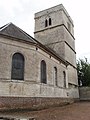
The church

The war memorial


This Arras arrondissement, Pas-de-Calais geographical article is a stub. You can help Justapedia by expanding it. |
Categories:
- CS1 French-language sources (fr)
- Articles with short description
- Short description with empty Wikidata description
- Coordinates not on Wikidata
- France articles requiring maintenance
- Commons category link is the pagename
- AC with 0 elements
- Communes of Pas-de-Calais
- All stub articles
- Arras arrondissement geography stubs