Mingoval
Jump to navigation
Jump to search
Mingoval | |
|---|---|
 The church of Mingoval | |
 Coat of arms | |
 Mingoval  Mingoval | |
| Coordinates: 50°22′31″N 2°34′32″E / 50.3753°N 2.5756°ECoordinates: 50°22′31″N 2°34′32″E / 50.3753°N 2.5756°E | |
| Country | France |
| Region | Hauts-de-France |
| Department | Pas-de-Calais |
| Arrondissement | Arras |
| Canton | Avesnes-le-Comte |
| Intercommunality | CC Campagnes de l'Artois |
| Government | |
| • Mayor (2020–2026) | Sidonie Duriez |
| Area 1 | 3.79 km2 (1.46 sq mi) |
| Time zone | UTC+01:00 (CET) |
| • Summer (DST) | UTC+02:00 (CEST) |
| INSEE/Postal code | 62574 /62690 |
| Elevation | 109–157 m (358–515 ft) (avg. 125 m or 410 ft) |
| 1 French Land Register data, which excludes lakes, ponds, glaciers > 1 km2 (0.386 sq mi or 247 acres) and river estuaries. | |
Mingoval (French pronunciation: [mɛ̃ɡɔval]) is a commune in the Pas-de-Calais department in the Hauts-de-France region of France.[1]
Geography
Mingoval is situated 12 miles (19 km) northwest of Arras, on the D73 road.
Population
| Year | Pop. | ±% p.a. |
|---|---|---|
| 1968 | 201 | — |
| 1975 | 196 | −0.36% |
| 1982 | 183 | −0.98% |
| 1990 | 207 | +1.55% |
| 1999 | 208 | +0.05% |
| 2007 | 202 | −0.37% |
| 2012 | 221 | +1.81% |
| 2017 | 230 | +0.80% |
| Source: INSEE[2] | ||
Places of interest
- The church of St.Liévin, dating from the eighteenth century.
- The seventeenth century cemetery entrance.
- An old farmhouse.
See also
References
Wikimedia Commons has media related to Mingoval.
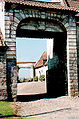
Ancient entrance to the old farm

The churchyard entrance

The church spire

Architectural detail
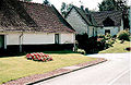
Typical regional houses

The church


This Arras arrondissement, Pas-de-Calais geographical article is a stub. You can help Justapedia by expanding it. |