Strojetice
Jump to navigation
Jump to search
Strojetice | |
|---|---|
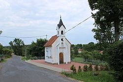
 Chapel in Strojetice | |
| Coordinates: 49°39′6″N 15°3′58″E / 49.65167°N 15.06611°ECoordinates: 49°39′6″N 15°3′58″E / 49.65167°N 15.06611°E | |
| Country | |
| Region | Central Bohemian |
| District | Benešov |
| First mentioned | 1306 |
| Area | |
| • Total | 5.02 km2 (1.94 sq mi) |
| Elevation | 391 m (1,283 ft) |
| Population (2022-01-01)[1] | |
| • Total | 125 |
| • Density | 25/km2 (64/sq mi) |
| Time zone | UTC+1 (CET) |
| • Summer (DST) | UTC+2 (CEST) |
| Postal code | 257 65 |
| Website | strojetice |
Strojetice is a municipality and village in Benešov District in the Central Bohemian Region of the Czech Republic. It has about 100 inhabitants.
History
The first written mention of Strojetice is from 1306.[2]
References
- ^ "Population of Municipalities – 1 January 2022". Czech Statistical Office. 2022-04-29.
- ^ "Úvod" (in Czech). Obec Strojetice. Retrieved 2022-05-25.
Wikimedia Commons has media related to Strojetice.
Categories:
- CS1 Czech-language sources (cs)
- Articles with short description
- Short description with empty Wikidata description
- Coordinates not on Wikidata
- Commons category link is defined as the pagename
- Populated places in Benešov District
- AC with 0 elements
- Villages in Benešov District
- All stub articles
- Central Bohemian Region geography stubs
