Neustupov
Jump to navigation
Jump to search
Neustupov | |
|---|---|
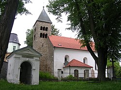
 Church of the Assumption of the Virgin Mary and the Chapel of Saint John of Nepomuk | |
| Coordinates: 49°36′54″N 14°41′55″E / 49.61500°N 14.69861°ECoordinates: 49°36′54″N 14°41′55″E / 49.61500°N 14.69861°E | |
| Country | |
| Region | Central Bohemian |
| District | Benešov |
| First mentioned | 1279 |
| Area | |
| • Total | 28.69 km2 (11.08 sq mi) |
| Elevation | 511 m (1,677 ft) |
| Population (2022-01-01)[1] | |
| • Total | 543 |
| • Density | 19/km2 (49/sq mi) |
| Time zone | UTC+1 (CET) |
| • Summer (DST) | UTC+2 (CEST) |
| Postal codes | 257 03, 257 86 |
| Website | www |
Neustupov is a market town in Benešov District in the Central Bohemian Region of the Czech Republic. It has about 500 inhabitants.
Administrative parts
Villages and hamlets of Barčov, Bořetice, Broumovice, Chlístov, Dolní Borek, Hojšín, Jiřetice, Královna, Podlesí, Sedlečko, Slavín, Vlčkovice, Vrchy, Záhoříčko, Zálesí and Žinice are administrative parts of Neustupov.
Geography
Neustupov lies in the Vlašim Uplands. The hill Mezivrata with 713 m (2,339 ft) above sea level is the highest point in the municipal territory.
References
Wikimedia Commons has media related to Neustupov.


