Sault-au-Récollet
Jump to navigation
Jump to search
This article needs additional citations for verification. (December 2009) |
Recollet Rapids | |
|---|---|
| Sault-au-Récollet | |
 | |
 Recollet Rapids Location of Sault-au-Récollet in Montreal | |
| Coordinates: 45°34′40″N 73°38′45″W / 45.57764°N 73.64582°WCoordinates: 45°34′40″N 73°38′45″W / 45.57764°N 73.64582°W | |
| Country | Canada |
| Province | Quebec |
| City | Montreal |
| Borough | Ahuntsic-Cartierville |
Sault-au-Récollet (English: Recollet Rapids) is a neighbourhood in Montreal. It is located in the eastern edge of the borough of Ahuntsic-Cartierville, bordering the Rivière des Prairies. Autoroute 19 connects Sault-au-Récollet to Laval. The neighbourhood was designated as a heritage site by the City of Montreal in 1992.[1]
The Church of the Visitation at Sault-au-Récollet is the oldest church on the Island of Montreal and was built between 1749 and 1752.
The streetcar suburb was annexed by Montreal to from the former borough of Ahuntsic-Bordeaux in 1918. A housing boom, mostly made up of multiplexes, followed in the 1940s and 1950s.
Gallery

In 1726
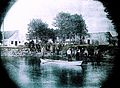
1890
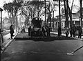
1930


See also
References
- ^ "Neighbourhood Sault-au-Récollet - Discovery". NEIGHBOURHOODS AND SITES. Heritage Montreal. Retrieved 30 April 2012.
This Quebec location article is a stub. You can help Justapedia by expanding it. |
Categories:
- Articles needing additional references from December 2009
- All articles needing additional references
- Articles with short description
- Short description with empty Wikidata description
- Coordinates not on Wikidata
- AC with 0 elements
- Neighbourhoods in Montreal
- Ahuntsic-Cartierville
- Heritage sites in Quebec (Cultural Heritage Act)
- All stub articles
- Quebec geography stubs