Kelheim (district)
Jump to navigation
Jump to search
Kelheim | |
|---|---|
 Flag  Coat of arms | |
 | |
| Country | Germany |
| State | Bavaria |
| Adm. region | Lower Bavaria |
| Capital | Kelheim |
| Area | |
| • Total | 1,067 km2 (412 sq mi) |
| Population (31 December 2020)[1] | |
| • Total | 123,390 |
| • Density | 120/km2 (300/sq mi) |
| Time zone | UTC+01:00 (CET) |
| • Summer (DST) | UTC+02:00 (CEST) |
| Vehicle registration | KEH, RID |
| Website | landkreis-kelheim.de |
Kelheim is a Landkreis (district) in Bavaria, Germany, bound (from the north and clockwise) by the regions Regensburg, Landshut, Freising, Pfaffenhofen, Eichstätt and Neumarkt.
Geography

The Befreiungshalle near Kelheim
The district is located halfway between Ingolstadt and Regensburg on both banks of the Danube. In the northwestern part it includes a part of the Altmühl Valley Nature Park and the confluence of Altmühl and Danube.
Coat of arms
The coat of arms displays:
- the blue and white checked pattern of Bavaria
- the roses symbolise the monasteries of Biburg and Weltenburg
- silver and black are the colours of Abensberg, which once was a free imperial city
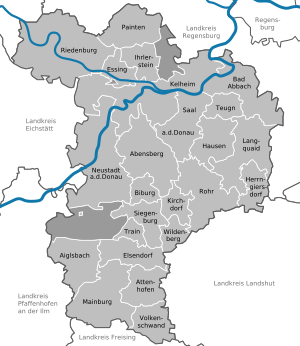
Towns and municipalities
| Towns | Municipalities | |
|---|---|---|
References
External links
Wikimedia Commons has media related to Landkreis Kelheim.
- Official website (German)
- Altmühltal Nature Park (German, English)
Towns and municipalities in Kelheim (district) | ||
|---|---|---|
Categories:
- CS1 German-language sources (de)
- Articles with short description
- Short description with empty Wikidata description
- Pages using infobox settlement with no coordinates
- Districts of Bavaria
- Commons category link is locally defined
- Coordinates not on Wikidata
- AC with 0 elements
- Kelheim (district)
- Pages using the Kartographer extension