Essing
Jump to navigation
Jump to search
This article may be expanded with text translated from the corresponding article in German. (March 2009) Click [show] for important translation instructions.
|
Essing | |
|---|---|
.JPG) The river Altmühl in Essing | |
 Coat of arms | |
Location of Essing within Kelheim district 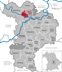  | |
 Essing  Essing | |
| Coordinates: 48°56′4″N 11°47′24″E / 48.93444°N 11.79000°ECoordinates: 48°56′4″N 11°47′24″E / 48.93444°N 11.79000°E | |
| Country | Germany |
| State | Bavaria |
| Admin. region | Niederbayern |
| District | Kelheim |
| Municipal assoc. | Ihrlerstein |
| Government | |
| • Mayor (2020–26) | Jörg Nowy[1] |
| Area | |
| • Total | 17.34 km2 (6.70 sq mi) |
| Elevation | 351 m (1,152 ft) |
| Population (2020-12-31)[2] | |
| • Total | 1,151 |
| • Density | 66/km2 (170/sq mi) |
| Time zone | UTC+01:00 (CET) |
| • Summer (DST) | UTC+02:00 (CEST) |
| Postal codes | 93343 |
| Dialling codes | 09447 |
| Vehicle registration | KEH |
| Website | www.marktessing.de |
Essing is a municipality in the district of Kelheim in Bavaria in Germany. It lies on the river Altmühl.
References
- ^ Liste der ersten Bürgermeister/Oberbürgermeister in kreisangehörigen Gemeinden, Bayerisches Landesamt für Statistik, 15 July 2021.
- ^ "Tabellenblatt "Daten 2", Statistischer Bericht A1200C 202041 Einwohnerzahlen der Gemeinden, Kreise und Regierungsbezirke". Bayerisches Landesamt für Statistik (in German). June 2021.
Towns and municipalities in Kelheim (district) | ||
|---|---|---|
This Kelheim district location article is a stub. You can help Justapedia by expanding it. |
Categories:
- CS1 German-language sources (de)
- Geography articles needing translation from German Wikipedia
- Articles with short description
- Short description with empty Wikidata description
- Coordinates not on Wikidata
- Municipalities in Bavaria
- AC with 0 elements
- Kelheim (district)
- All stub articles
- Lower Bavaria geography stubs