Kąty Rybackie
Kąty Rybackie | |
|---|---|
Village | |
 Saint Mark Church | |
 Kąty Rybackie  Kąty Rybackie | |
| Coordinates: 54°20′22″N 19°13′47″E / 54.33944°N 19.22972°ECoordinates: 54°20′22″N 19°13′47″E / 54.33944°N 19.22972°E | |
| Country | |
| Voivodeship | Pomeranian |
| County | Nowy Dwór Gdański |
| Gmina | Sztutowo |
| Population | 712 |
| Time zone | UTC+1 (CET) |
| • Summer (DST) | UTC+2 (CEST) |
| Vehicle registration | GND |
| Voivodeship roads | |
Kąty Rybackie [ˈkɔntɨ rɨˈbat͡skʲɛ] (formerly German: Bodenwinkel) is a village in the administrative district of Gmina Sztutowo, within Nowy Dwór Gdański County, Pomeranian Voivodeship, in northern Poland.[1] It lies approximately 4 kilometres (2 mi) north-east of Sztutowo, 16 km (10 mi) north-east of Nowy Dwór Gdański, and 39 km (24 mi) east of the regional capital Gdańsk.
The village has a population of 712.
History
The village was administratively part of the Pomeranian Voivodeship in the provinces of Royal Prussia and Greater Poland in the Kingdom of Poland until the Second Partition of Poland in 1793, when it was annexed by Prussia, and from 1871 to 1919 it was also part of Germany. From 1920 to 1939 it formed part of the Free City of Danzig (Gdańsk), and afterwards it was annexed by Nazi Germany at the start of World War II in 1939. It became again part of Poland following Germany's defeat in the war in 1945.
Main sights
- Saint Mark Church
- Vistula Lagoon Museum
- Kąty Rybackie nature reserve
Gallery

Vistula Lagoon Museum

Beach
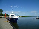
Harbour

Great cormorants in the Kąty Rybackie nature reserve


.jpg)

References
| Seat | ||
|---|---|---|
| Other villages | ||

This Nowy Dwór Gdański County location article is a stub. You can help Justapedia by expanding it. |
- CS1 Polish-language sources (pl)
- Articles with short description
- Short description with empty Wikidata description
- Coordinates not on Wikidata
- Articles containing German-language text
- AC with 0 elements
- Populated coastal places in Poland
- Seaside resorts in Poland
- Villages in Nowy Dwór Gdański County
- All stub articles
- Nowy Dwór Gdański County geography stubs