Chałupy
Chałupy | |
|---|---|
Village | |
 Voivodeship road no 216 in Chałupy | |
 Chałupy | |
| Coordinates: 54°46′N 18°31′E / 54.767°N 18.517°E | |
| Country | |
| Voivodeship | Pomeranian |
| County | Puck |
| Gmina | Władysławowo |
| Population (2009) | 376 |
| Postal code | 84-120 |
| Area code | +48 58 |
Chałupy (Kashubian: Chalëpë or Chałëpë, German: Ceynowa or Ziegenhagen) is a Seaside resort and a Polish village with conditions favorable for windsurfing and kitesurfing, in Gmina Władysławowo. It is situated between Władysławowo and Kuźnica on the Hel Peninsula on the southern Baltic Sea in Puck County, Pomeranian Voivodeship, northern Poland. Its population in 2009 was 376.
In 1836 the village was the site of one of the last, if not the last, lynchings related to accusations of sorcery, when a widow Krystyna Ceynowa was killed by a mob after being accused of being a witch.[1]
In 1939 the village saw some fighting during the battle of Hel. The Germans captured it on 25 September, and around the same time, in its vicinity, Polish military engineers detonated torpedo warheads, temporarily transforming the Peninsula's far end into an island.[2][3]
Before 1 January 2015, Chałupy was part of the town of Władysławowo.[4]
Toward the last years of communist rule in Poland the locality became famous as the site of a government-legal nudist beach.[5]
Gallery
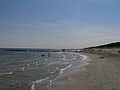
Beach in Chałupy

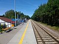
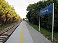
Chałupy train station

Church in Chałupy


_Travelarz.jpg)

References
- ^ Jóźwiak, Krzysztof (15 October 2016). "Procesy czarownic w Rzeczypospolitej Obojga Narodów". www.rp.pl (in Polish). Retrieved 2020-09-01.
- ^ Komorowski, Krzysztof, ed. (2009). "Hel (1 IX-2 X 1939)". Boje Polskie 1939–1945. Przewodnik Encyklopedyczny [Poland's Battles, 1939–1945: an Encyclopedic Guide] (in Polish). Warsaw: Bellona. pp. 121–124. ISBN 9788311103573.
- ^ Commager, Henry Steele (2004). The Story of the Second World War. Sterling, VA: Potomac Books, Inc. pp. 16–19. ISBN 9781574887419.
- ^ Rozporządzenie Rady Ministrów z dnia 29 lipca 2014 r. w sprawie połączenia gmin, ustalenia granic niektórych gmin i miast, nadania niektórym miejscowościom statusu miasta oraz zmiany siedziby władz gminy, Dz. U. z 2014 r. poz. 1023 (2014-07-29)
- ^ "History of Communism in Poland". September 2021. Archived from the original on 2021-12-03.
External links
- www.chalupy.pl - Official website
- www.google/maps/lemonpark - Lemon Park Władysławowo on Google Maps
| Seat | ||
|---|---|---|
| Other villages | ||

Coordinates: 54°46′N 18°31′E / 54.767°N 18.517°E
This Pomeranian Voivodeship location article is a stub. You can help Justapedia by expanding it. |
- Pages with short description
- CS1 Polish-language sources (pl)
- Articles with short description
- Short description with empty Wikidata description
- Articles containing Kashubian-language text
- Articles containing German-language text
- Commons category link is locally defined
- AC with 0 elements
- Coordinates not on Wikidata
- Puck County
- Neighbourhoods in Poland
- All stub articles
- Pomeranian geography stubs