Yish'i
Yish'i | |
|---|---|
 | |
 Yish'i | |
| Coordinates: 31°45′3″N 34°58′0″E / 31.75083°N 34.96667°ECoordinates: 31°45′3″N 34°58′0″E / 31.75083°N 34.96667°E | |
| Country | Israel |
| District | Jerusalem |
| Council | Mateh Yehuda |
| Affiliation | Hapoel HaMizrachi |
| Founded | 12 July 1950 |
| Founded by | Yemenite Jews |
| Population (2019)[1] | 771 |
Yish'i (Hebrew: יִשְׁעִי, lit. My Salvation) is a moshav in central Israel. Located near Beit Shemesh, it falls under the jurisdiction of Mateh Yehuda Regional Council. In 2019 it had a population of 771.
History
The village was established on 12 July 1950 by immigrants from Yemen on land that had belonged to the depopulated Palestinian village of Dayr Aban.[2] Its name it taken from Psalms 27:1;
The LORD is my light and my salvation; whom shall I fear? The LORD is the stronghold of my life; of whom shall I be afraid?
The modern village is built immediately west of the ruins of biblical Beit Shemesh (Hebrew: Tel Beit Shemesh, Arabic: ʿAin Shems).[3] Directly to the south-west of the modern village lies another ancient ruin, believed to date back to the Second Temple period, now called Khurbet Bîr el-Leimûn (the Lemon well).[4]
Gallery

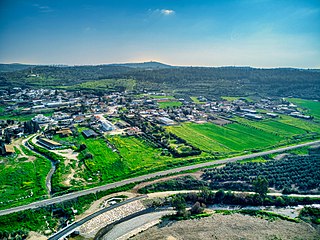
A view of Yish'i

Yish'i - East of Yish'i riverbed
Yish'i - West of Yish'i riverbed


References
- ^ "Population in the Localities 2019" (XLS). Israel Central Bureau of Statistics. Retrieved 16 August 2020.
- ^ Khalidi, Walid (1992). All That Remains: The Palestinian Villages Occupied and Depopulated by Israel in 1948. Washington D.C.: Institute for Palestine Studies. p. 283. ISBN 0-88728-224-5.
- ^ On this ancient biblical site, see I Samuel 6:1–ff.
- ^ Survey of Western Palestine, 1880 Map, Map 17: IAA, wikimedia commons, as surveyed and drawn under the direction of Lieut. C.R. Conder and H.H. Kitchener, May 1878.
- Articles with short description
- Short description with empty Wikidata description
- Coordinates not on Wikidata
- Articles containing Hebrew-language text
- Commons link is the pagename
- Mateh Yehuda Regional Council
- Moshavim
- Populated places established in 1950
- Populated places in Jerusalem District
- Yemeni-Jewish culture in Israel
- 1950 establishments in Israel