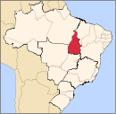
Xambioá, Tocantins
Jump to navigation
Jump to search
Xambioá | |
|---|---|
Municipality | |
| Country | |
| Region | Northern |
| State | Tocantins |
| Mesoregion | Ocidental do Tocantins |
| Microregion | Araguiana |
| Population (2020 [1]) | |
| • Total | 11,520 |
| Time zone | UTC -3 |
Xambioá is a municipality in the state of Tocantins in the Northern region of Brazil.[2] It is located at 06º24'40" south latitude and 48º32'11" west longitude, being located on the right bank of the Araguaia River, at an altitude of 141 meters. Estimated population in 2007 was 10,856.
The municipality contains 43% of the 18,608 hectares (45,980 acres) Lago de Santa Isabel Environmental Protection Area, created in 2002.[3]
See also
References
- ^ "IBGE 2020". Retrieved 26 January 2021.
- ^ "IBGE | Cidades | Tocantins | Xambioá". cidades.ibge.gov.br. Retrieved 2016-05-08.
- ^ APA Lago de Santa Isabel (in Portuguese), ISA: Instituto Socioambiental, retrieved 2017-02-08
Coordinates: 6°24′39″S 48°32′9″W / 6.41083°S 48.53583°W
Categories:
- CS1 Portuguese-language sources (pt)
- Articles with short description
- Short description with empty Wikidata description
- Pages using infobox settlement with no map
- Pages using infobox settlement with no coordinates
- Coordinates not on Wikidata
- Municipalities in Tocantins
- All stub articles
- Tocantins geography stubs


