Wright's Town, Lower Canada
Wright's Town is the name of the first permanent colonial settlement in the Ottawa Valley, Canada. It later became the City of Hull, Quebec, incorporated in 1875, and in 2002, it became Gatineau, Quebec after an amalgamation of the cities of Aylmer, Hull, Gatineau, Buckingham, and Masson-Angers.[1] The town was situated at the north edge of the Chaudière Falls on the Ottawa River on the southern part of what is known today as Hull Island.

Wright's Town was founded by Philemon Wright, an American from Woburn, Massachusetts. Philemon arrived with his family and associates on March 7, 1800 at the banks of the Gatineau River and the Ottawa River.[2] The town was originally created to support the agricultural settlement that Philemon Wright and his brother Thomas had planned to build but with the launching of the Columbo - the first square timber raft floated on the Ottawa River in 1806 - Wright's Town became the birthplace and center of the Ottawa Valley timber trade.[3]
The first two of the 20+ farms cleared in the settlement were the Gateno Farm (1800) and the Columbia Falls Farm (1801), the former being named for its situation on the Gateno River (sic) and the latter being situated at the Columbia Falls, which was the name that Philemon gave to the Chaudière Falls, a name used by his family and associates but a name that never caught on with others.[4] So, although Philemon called his town Columbia Falls Village, most others called it Wright's Town (and Wrightstown) or Wright's Village.[5] Contrary to what some modern journalists have written, the town was never called Wrightsville or Wrightville. Wrightville was just the name of a sector that was created in the City of Hull when the City was incorporated in 1875.[6][circular reference]
Overview

In 1799, Philemon Wright acquired a land grant from the British Crown under the "leader and associates" regime for roughly a quarter of the land in the Township of Hull in Lower Canada.[7] When Philemon Wright arrived in 1800, he was accompanied by four other families and 33 axemen/labourers. Along with his wife Abigail and six Children, the other families included his brother Thomas, wife Mary and their children, his two sisters-in-law, Margery and Lavina with husbands Samuel Choate and John Allen, and children, and London Oxford with his wife, and possibly their children.[8] London Oxford was a free, black man. Thomas Wright died in the first year of the settlement but within two years, the number of associates grew to twelve: Wright's sons Philemon and Tiberius, Harvey Parker, Daniel Wyman, Ephraim and Edmond Chamberlin, Luther Colton, James and William McConnell, and Isaac Remic.[9]
For the first 26 years, Wright's Town was the center of commerce, industry, and agriculture in the Ottawa Valley. It was the settlement from which all of the other Ottawa Valley settlements grew.[10] The towns of Aylmer, Quebec, Richmond, Ontario, Chelsea, Quebec and Wakefield, Quebec were all born from Wright's Town. Bytown, which would later become Ottawa, the Nation's Capital, was no exception. So when, in 1826, the Crown decided to build the Union Bridge (Chaudière Bridge, today) and the Rideau Canal, Wright's Town became the staging ground for what would be the greatest engineering project of its kind at the time in North America.[11]
The Town
At first, the town grew around the Common, borrowing its design from the many New England towns where Philemon and the other first settlers grew up. Most New England towns had a Meeting house with a bell at the center of a village Common where you would also often find a tavern and store. The Meetinghouse could serve both political functions as well as religious gatherings.[12][13] An imposing whitewashed-stone building with a cupola (bell-tower) was central in the Common at Wright's Town - as can be seen in all of the paintings of the town. It was built in 1819 and can be seen in the Burrows map of 1824, identified as the New Stone Store. It appears to have been a multi-purpose building that is also identified as Wright's Tavern in the DuVernet painting, as the Office & Store in the Swallwell map of 1844, and as a Meeting-House (sic) by Joseph Bouchette, Surveyor General of Lower Canada.[14] The Upper Village was also where the hotel, the mills, the foundry, the bakehouse, the tannery, and several other shops nearby. The Lower Village of Wright's Town was closer to the Steamboat wharf downriver, and it would only be laid out just before construction of the Rideau Canal was to begin, in 1826.
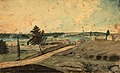
Hull, (Lower Canada), on the Ottawa River; at the Chaudiere Falls, 1830 by Thomas Burrowes

A map of Wright's Town by John Burrows in 1824
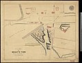
Plan of Wrightstown
,_on_the_Ottawa_River;_at_the_Chaudier_(sic)_Falls,_1830.jpg)

_Jos._Aub%C3%A9_1885.jpg)
References
- ^ https://www.gatineau.ca/docs/guichet_municipal/archives/docs/histoire_de_la_cite_de_hull_pp01-48.pdf[bare URL PDF]
- ^ Appendix to the XXXIIIIRD Volume of the Journals of the House of Assembly of the Province of Lower-Canada. Fourth Session of the Eleventh Provincial Parliament; Sketch of the First Settlement on the Ottawa or Grand River; The Committee having requested from P. WRIGHT; 1824.
- ^ Woods Jr., Shirley E. (1980). Ottawa, the Capital of Canada. Toronto: Doubleday. ISBN 0-385-14722-8.
- ^ Appendix to the XXXIIIIRD Volume of the Journals of the House of Assembly of the Province of Lower-Canada. Fourth Session of the Eleventh Provincial Parliament; Sketch of the First Settlement on the Ottawa or Grand River; The Committee having requested from P. WRIGHT; 1824.
- ^ B. S. Elliott, "‘The famous township of Hull’: image and aspirations of a pioneer Quebec community," SH, 12 (1979): pg 348
- ^ fr:Quartiers de Gatineau
- ^ B. S. Elliott, "‘The famous township of Hull’: image and aspirations of a pioneer Quebec community," SH, 12 (1979): pg 341
- ^ Wright Papers, Library & Archives Canada, Vol. 126, p. 66568
- ^ B. S. Elliott, "‘The famous township of Hull’: image and aspirations of a pioneer Quebec community," SH, 12 (1979): pg 344
- ^ Brault, Lucien. Hull 1800-1950. Ottawa: Les Éditions de l'Université d'Ottawa, 1950, pg. 29
- ^ "Rideau Canal | the Canadian Encyclopedia".
- ^ Meetinghouses of Early New England. University of Massachusetts Press. 2012. ISBN 9781613762288.
- ^ "Colonial Meetinghouses of New England".
- ^ A topographical description of the province of Lower Canada _ with remarks upon Upper Canada, and on the relative connexion of both provinces with the United States of America; pg. 252