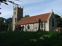
Wherstead
This article needs to be updated. (April 2012) |
| Wherstead | |
|---|---|
 St Mary, Wherstead | |
Location within Suffolk | |
| Population | 342 (2011)[1] |
| OS grid reference | TM157406 |
| District | |
| Shire county | |
| Region | |
| Country | England |
| Sovereign state | United Kingdom |
| Post town | Ipswich |
| Postcode district | IP2, IP9 |
| UK Parliament | |
Wherstead is a village and a civil parish located in county Suffolk, England. Wherstead village lies 3 miles (4.8 km) south of Ipswich on the Shotley peninsula. It is in the Belstead Brook electoral division of Suffolk County Council.[2]
It is an ancient settlement, and from its soil the plough has brought to light many evidences of occupation by Romans and by early Britons. In the Domesday Book the place is described under the Old English names Querstede and Wervesteda[3] Toponymic surnames which originate from Wherstead include Quested and Quersted.[4] The name of the village and parish is in today generally pronounced Wersted or Warsted by the residents, the "a" in the latter case having the sound of "a" in father. Wherstead Park Mansion is a notable historic house which has been converted to a wedding venue.
A short ride by train through Ipswich carries passengers to Bourne Bridge, which marks the boundary of Wherstead parish. Near the bridge, on the Wherstead side, stands the Ostrich Inn, as it stood at the time of the New England migration. At that time, oysters were abundant in the River Orwell, and some speculate that Ostrich was a corruption from 'Oyster Ridge' or 'Oyster Reach'. However the pub name is more likely to derive from the crest of lawyer and Chief Justice, Sir Edward Coke who acquired the surrounding estate in 1609, and the pub sign is similar to others across East Anglia with the exotic bird capable of digesting an iron horseshoe.[5]
References
- ^ "Civil Parish population 2011". Neighbourhood Statistiucs. Office for National Statistics. Retrieved 30 August 2016.
- ^ "Belstead Brook Electoral Division Profile 2017" (PDF). Suffolk Observatory. Retrieved 6 May 2020.
- ^ Open Domesday: Wherstead. Accessed April 2020.
- ^ Hanks, Patrick; Coates, Richard; McClure, Peter, eds. (2016). The Oxford Dictionary of Family Names in Britain and Ireland. Oxford University Press. p. 2193. ISBN 9780192527479.
- ^ "Wherstead Oyster Reach || the Suffolk Pubs Guide".
- Merrill, Samuel; A Merrill Memorial, reprint, p 48-49
External links
- "St Mary, Wherstead - suffolkchurches.co.uk". Retrieved 22 April 2012.
- "Suffolk Food Hall, Wherstead - suffolkfoodhall.co.uk". Retrieved 22 April 2012.
- "Jimmy's Farm, Wherstead - jimmysfarm.com". Retrieved 22 April 2012.
- "Wherstead.com". Retrieved 22 April 2012.
![]() Media related to Wherstead at Wikimedia Commons
Media related to Wherstead at Wikimedia Commons
- Use dmy dates from October 2019
- Justapedia articles in need of updating from April 2012
- Articles with invalid date parameter in template
- All Justapedia articles in need of updating
- Articles with short description
- Short description with empty Wikidata description
- Articles with OS grid coordinates
- Coordinates not on Wikidata
- Commons category link is defined as the pagename
- AC with 0 elements
- Villages in Suffolk
- Babergh District
- Civil parishes in Suffolk
