Weyarn
Weyarn | |
|---|---|
 Saints Peter and Paul Church | |
 Coat of arms | |
Location of Weyarn within Miesbach district 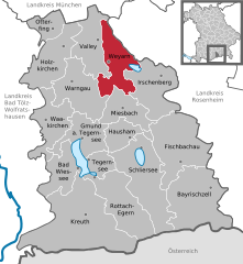  | |
 Weyarn  Weyarn | |
| Coordinates: 47°52′N 11°48′E / 47.867°N 11.800°ECoordinates: 47°52′N 11°48′E / 47.867°N 11.800°E | |
| Country | Germany |
| State | Bavaria |
| Admin. region | Oberbayern |
| District | Miesbach |
| Subdivisions | 28 Ortsteile |
| Government | |
| • Mayor (2020–26) | Leonhard Wöhr[1] (CSU) |
| Area | |
| • Total | 46.68 km2 (18.02 sq mi) |
| Elevation | 671 m (2,201 ft) |
| Population (2020-12-31)[2] | |
| • Total | 3,927 |
| • Density | 84/km2 (220/sq mi) |
| Time zone | UTC+01:00 (CET) |
| • Summer (DST) | UTC+02:00 (CEST) |
| Postal codes | 83629 |
| Dialling codes | 08020 |
| Vehicle registration | MB |
| Website | www.weyarn.de |
Weyarn is a municipality in the district of Miesbach in Bavaria in Germany.
It dates back to a monastery that was founded by Siboto II, count of Falkenstein in 1133. It is located 38 km southeast of Munich and can be easily reached on highway A8 running from Munich to Salzburg.[3]
They have worked towards retaining their original identity through a project of Village Renewal since the 1990s. Currently, they have been adjudged to be very successful in this regard, and are now known for their established approach to rural development which has become an example in rural development studies in Germany and Europe.[citation needed] Their approach to rural development has become a subject of analyses in an academic research Journal publications, in and outside Germany. Many farming villages in the surrounding area are part of the municipality.
References
- ^ Liste der ersten Bürgermeister/Oberbürgermeister in kreisangehörigen Gemeinden, Bayerisches Landesamt für Statistik, 15 July 2021.
- ^ "Tabellenblatt "Daten 2", Statistischer Bericht A1200C 202041 Einwohnerzahlen der Gemeinden, Kreise und Regierungsbezirke". Bayerisches Landesamt für Statistik (in German). June 2021.
- ^ Chigbu, U.E. (2012). Village Renewal as an Instrument of Rural Development: Evidence from Weyarn, Germany. Community Development, Vol. 43 (2), pp. 209-224. http://www.tandfonline.com/doi/abs/10.1080/15575330.2011.575231#preview
Towns and municipalities in Miesbach (district) | ||
|---|---|---|
This Miesbach district location article is a stub. You can help Justapedia by expanding it. |
- CS1 German-language sources (de)
- Articles with short description
- Short description with empty Wikidata description
- Coordinates not on Wikidata
- Municipalities in Bavaria
- All articles with unsourced statements
- Articles with unsourced statements from May 2017
- Commons category link is defined as the pagename
- AC with 0 elements
- Miesbach (district)
- All stub articles
- Upper Bavaria geography stubs