Wangapeka Track
| Wangapeka Track | |
|---|---|
 Karamea River by Helicopter Flat Hut | |
| Length | 59 km (37 mi) |
| Location | Kahurangi National Park |
| Trailheads |
|
| Use | Tramping |
| Elevation gain/loss | 3,206 metres (10,520 ft) gain |
| Highest point | 1,087 m (3,566 ft) |
| Lowest point | 60 m (200 ft) |
| Difficulty | Medium |
| Maintained by | Department of Conservation |

The Wangapeka Track is a tramping track in the north west of the South Island of New Zealand. It traverses the southern end of the Kahurangi National Park from the historic Wangapeka goldfields area west of Tapawera, to the coastal plains of the West Coast at Little Wanganui. The route is 59 km (37 mi) long, and crosses two saddles, each over 1,000 m (3,300 ft) in elevation. It typically takes walkers 4–6 days to complete. The route passes through the valleys of the Wangapeka River, Karamea River, Taipō River and Little Wanganui River. The majority of the track is in river valleys and under forest cover, with small sections in tussock land at Stag Flat and the Little Wanganui Saddle.[1]
History
The origins of the Wangapeka Track date back to the discovery of gold in the Wangapeka River in 1859, following a survey by the geologist Ferdinand von Hochstetter. There was a further discovery of gold in the Rolling River in May 1861. An explorer and surveyor John Rochfort created a basic track from Rolling River, up the Wangapeka River valley and over the Wangapeka Saddle to the Karamea River. The work was funded by the Nelson Provincial Council, and employed gold diggers as labourers to build the track.[2]
Wangapeka to Little Wanganui Saddle
By the mid-1880s, there was a diggers pack track from the Rolling River to the mouth of the Kiwi Stream. In 1887, the Public Works Department constructed a packhorse track with grades suitable for carts, from Kiwi Stream to the Wangapeka Saddle.
.jpg)
In 1895, Chief Surveyor John S Browning visited the track and reported that it had not been maintained. He inspected the rest of the proposed route to the West Coast, and estimated that a packhorse track could be completed from Wangapeka to Little Wanganui for £3,500. Jonathan Brough was appointed to lead the construction of the track from Wangapeka Saddle to the headwaters of the Karamea River.[3] Contracts for the construction were let in quarter-mile sections. Up to 20 men were hired to work on building the track, most of them unemployed diggers. The track reached the valley floor of the Karamea River by 1896, and through the Karamea River gorge by 1897. In 1889, Brough constructed an “A” framed shelter at a lookout point above the Taipō River at its junction with the Karamea River. This shelter became known as the Tabernacle. This era of track construction by contract ended when the track reached the present site of Taipō Hut. However, further work was completed, cutting a track through open tussock to the area now known as Stag Flat, and then in a zig-zag up the steep section to Little Wanganui Saddle.[2]
Little Wanganui inland to the saddle
Settlers in the Little Wanganui area wanting to graze stock inland requested the construction of a track to open up the interior for farming. A route inland from Little Wanganui was surveyed in 1894 and 3 mi (4.8 km) of packhorse track was cut, using unemployed men from the Mohikinui mine. Work progressed slowly, but by 1899 there was 4.5 mi (7.2 km) of dray road, and a pack track up the north bank of the Little Wanganui River to the gorge. From there a roughly cut route followed the river and then up the slopes of Mount Zetland to the Little Wanganui Saddle and down to Stag Flat.[2]
Murchison earthquake
The Murchison earthquake on 17 June 1929 created large and widespread landslides that caused severe damage to the track,[4] and destroyed the sections of the route across the slopes of Mount Zetland to the west of the Little Wanganui Saddle. Some damaged sections were rebuilt during the depression of the 1930s, using funding from the gold-mining subsidy for unemployed men.[5]
Forest Park to National Park
The New Zealand Forest Service established the North West Nelson Forest Park in 1965, incorporating the route of the Wangapeka Track. At that time, many of the tracks in the park were overgrown. The Forest Service started on a programme of work to promote recreation in the park, including cutting new tracks and building huts. The North West Nelson Forest Park was gazetted in 1970,[6] and transferred to the newly formed Department of Conservation in 1987. [7] The area of the North West Nelson Forest Park became the newly formed Kahurangi National Park in 1996.[8]
Access
The eastern end of the track starts in the Wangapeka River valley 84 km (52 mi) south-west of Nelson.[9] There is a campsite known as Siberia, close to the start of the track.[10]
The West Coast end of the track is in the Little Wanganui Valley around 80 km (50 mi) north of Westport and 18 km (11 mi) south of Karamea.[1]
Route

The track can be walked in either direction, but the east to west journey is described here.
Rolling River to Kings Creek Hut
At the start of the track, there is a footbridge across the Rolling River. The track then follows the true right of the Wangapeka River. There are several tributaries to cross on the route, but these are bridged. The forest in this area is regenerating from the early attempts at clearing the land for grazing. There is a bridge across the north branch of the Wangapeka River at the junction with Kiwi Stream, and from this point the route follows the true left of the Wangapeka River to Kings Creek Hut.[11]
Kings Creek Hut to Stone Hut
The track passes the historic Cecil King hut and follows the true left of the Wangapeka River. The route climbs steadily to a bridge across to the true right, before reaching Stone Hut.[11]
Cecil Kings Hut

During the economic depresson of the 1930s the government subsidised unemployed men to revisit old gold mining areas,[12][13] with the hope of recovering fresh gold. While the work was hard and the efforts were usually unsuccessful, for some of the men the experience of backcountry life was enjoyable. Cecil King from Wellington was one of those who went prospecting in the area of the Wangapeka River. Along with some other miners, in 1935 King built a small slab hut near the junction of the south and north branches of the Wangapeka River. He travelled from Wellington to live in the hut during summer times over a period of 46 years.[14] He spent more time at the hut after he retired, and developed a flume system to assist with gold mining. King generally welcomed travellers, and was known to offer hospitality.[14] After he died in 1982, his son scattered his ashes close to the hut. In 1991, the hut was restored by the Department of Conservation,[1] with work led by a former Forest Park ranger, Max Polglaze.[15]
Stone Hut to Helicopter Flat Hut
From this point, the route climbs out of the Wangapeka River valley, crossing a large slip. The track ascends steeply to the Wangapeka Saddle, under forest cover at an elevation of 1,009 m (3,310 ft)), before descending into the Karamea River headwaters.[11]
Alternative route via Biggs Tops
From the Wangapeka Saddle there is an alternative route over Biggs Tops. This route descends to Trevor Carter Hut, from where there are three alternatives for rejoining the main Wangapeka Track:[1][16]
- Lost Valley Track to Helicopter Flat Hut
- Saxon Falls Track, joins the main track again near the Tabernacle lookout
- across the Karamea River and along the true left bank to Taipō River footbridge.
Helicopter Flat Hut to Taipō Hut
There are two route options from Helicopter Hut. The main route climbs above the true right of the Karamea River to a historic site called Brough's Tabernacle, and then into the catchment of the Taipō river. There is also a longer route via a low saddle into Lost Creek, and to the Trevor Carter Hut. From this point there are two options for rejoining the main Wangapeka Track.[11]
Taipō Hut to Belltown Manunui Hut
From the Taipō Hut, the route gradually ascends to the Taipō River headwaters, and passes Stag Flat shelter with a steep climb to Little Wanganui Saddle – the highest elevation on the track at (1,087 m (3,566 ft)). The descent from the saddle passes the Saddle Lakes before returning into the forest again. The route then descends steeply into the headwaters of the Little Wanganui River. The track crosses to the true right on a swingbridge, and then follows the true right to the Belltown Manunui Hut.[11]
Belltown Manunui Hut to Wangapeka Road
The route from Belltown Manunui Hut follows the true right of the Little Wanganui River and through an open area known as Gilmor Clearing. The track then follows an old access road before returning to the Little Wanaguni River and on to the car park at the end of Wangapeka Road.[11]
- Wangapeka Track impressions

Wangapeka River

Kings Creek Hut
Stone Hut

Karamea River

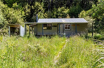
Helicopter Flat Hut

Biggs Tops Route

Trevor Carter Hut

Kendall Valley from Biggs Tops Route

Saddle Lake from Little Wanganui Saddle


Proposals for a through-road
Proposals for a through-route from Wangapeka to Karamea, suitable for horse-drawn vehicles, were made in 1868 by the Provincial Engineer.[17] In 1915, a deputation from Nelson lobbied the Minister of Public Works, William Fraser, about the need for a Wangapeka-Karamea road to enable stock to be moved between the regions.[18] In 1924, the Karamea Progress League lobbied the Nelson Chamber of Commerce about the urgency of completing a road over the route.[19] There was further pressure from farming interests in 1920 and 1924 to build a road over the Wangapeka track through to Karamea, to permit stock movement between the Nelson and Karamea regions.[20][21]
In 1968, the idea was proposed again, but the Minister of Works stated in a letter to the South Island Publicity Association:
The cost of constructing and maintaining a road over the high passes on the Wangapeka route and through badly faulted earthquake shattered country would be prohibitive [22]
A new proposal for a road through the Wangapeka track was made in 1973, as part of lobbying in opposition to the proposal for a road through the Heaphy Track. The President of the Organisation to Preserve the Heaphy advocated for a road through the Wangapeka as an alternative that would avoid a road through the Heaphy.[23]
The idea was raised again in 2015 by the Mayor of Buller as a means of boosting the West Coast economy in response to the decline of the coal industry. Points raised in opposition included the threats that a road through the Wangapeka would pose for endangered birds including rock wrens and whio (blue duck).[24] Opposition to the latest proposal for a road included this response:
The Wangapeka Track provides a rare glimpse of primordial New Zealand. It feels remote and ancient. A lot has been invested into protecting the native wildlife, particularly the nationally vulnerable whio, in the area. A road would likely require widespread deforestation and destruction of habitat. Once a road is built there's no going back. [25]
References
- ^ a b c d "Wangapeka Track route Guide" (PDF). Department of Conservation. Archived (PDF) from the original on 16 June 2021. Retrieved 2 August 2022.
- ^ a b c Wangapeka Track – North West Nelson State Forest Park (2nd ed.). Nelson: New Zealand Forest Service. November 1985.
- ^ "Jonathan Brough". The Nelson Provincial Museum – Pupuri Taonga o Te Tai Ao. Archived from the original on 3 August 2022. Retrieved 4 August 2022.
- ^ "Wangapeka – Karamea track – Erection of signs suggested". Nelson Evening Mail. 10 November 1945. Archived from the original on 1 September 2022. Retrieved 1 September 2022 – via Papers Past.
- ^ "Wangapeka Track – Government grant of £25". Nelson Evening Mail. 15 November 1932. Archived from the original on 3 August 2022. Retrieved 3 August 2022 – via Papers Past.
- ^ "New forest park". The Press. 17 September 1970. Archived from the original on 3 August 2022. Retrieved 3 August 2022 – via Papers Past.
- ^ Barnett, Shaun (19 January 2013). "Ranger's legacy of comfort". Nelson Mail. Archived from the original on 3 August 2022. Retrieved 3 August 2022 – via PressReader.
- ^ Walrond, Carl (7 September 2010). "Nelson places - North-west Nelson". teara.govt.nz. New Zealand Ministry for Culture and Heritage Te Manatu. Archived from the original on 9 September 2022. Retrieved 9 September 2022.
- ^ Bell, Valerie (1975). Trips in and around the Wangapeka Valley. Wellington: New Zealand Forest Service.
- ^ "Siberia Flat Campsite". Department of Conservation. Archived from the original on 24 February 2022. Retrieved 3 August 2022.
- ^ a b c d e f Lua error in Module:Cite_Q at line 13: attempt to index a nil value.
- ^ "Gold prospecting – among the unemployed". Nelson Evening Mail. 7 March 1933. Archived from the original on 3 August 2022. Retrieved 3 August 2022 – via Papers Past.
- ^ "Mining committee of Waimea County Council". Nelson Evening Mail. 9 March 1934. Archived from the original on 3 August 2022. Retrieved 3 August 2022 – via Papers Past.
- ^ a b Arnold, Naomi (July–August 2019). "Cecil King's Hut". New Zealand Geographic (158). Archived from the original on 2 November 2021. Retrieved 3 August 2022.
- ^ Lua error in Module:Cite_Q at line 13: attempt to index a nil value.
- ^ "Wangapeka Track". NZ Topo Map. Archived from the original on 3 August 2022. Retrieved 3 August 2022.
- ^ "Karamea roads and their cost". Colonist. 26 May 1868. Archived from the original on 2 September 2022. Retrieved 2 September 2022 – via Papers Past.
- ^ "Nelson deputations". Colonist. 27 March 1915. Archived from the original on 2 September 2022. Retrieved 2 September 2022 – via Papers Past.
- ^ "Karamea – Wangapeka track". Nelson Evening Mail. 11 April 1924. Archived from the original on 2 September 2022. Retrieved 2 September 2022 – via Papers Past.
- ^ "Karamea and Nelson – Need for cattle track to benefit both districts". Nelson Evening Mail. 11 March 1920. Archived from the original on 2 September 2022. Retrieved 2 September 2022 – via Papers Past.
- ^ "Wangapeka Track – Extension to Karamea urged". Nelson Evening Mail. 7 August 1924. Archived from the original on 2 September 2022. Retrieved 2 September 2022 – via Papers Past.
- ^ "Link with Karamea". The Press. 20 March 1968. Archived from the original on 2 September 2022. Retrieved 2 September 2022 – via Papers Past.
- ^ "Wangapeka route would save Heaphy – O.P H." The Press. 30 March 1973. Archived from the original on 2 September 2022. Retrieved 2 September 2022 – via Papers Past.
- ^ Carroll, Joanne; Mitchell, Charlie (14 December 2015). "New road linking West Coast to Nelson would bring 'life after coal'". Stuff. Archived from the original on 2 September 2022. Retrieved 1 September 2022.
- ^ Carson, Jonathan (10 June 2017). "Paving paradise: The case against building a road through Kahurangi National Park". Stuff. Archived from the original on 2 September 2022. Retrieved 2 September 2022.
Further reading
- J.N.W. Newport (May 1957). "Goldfields in the Upper Motueka and Buller Valleys – Wangapeka". Nelson Historical Society Journal. Nelson Historical Society. 1 (2). Retrieved 4 August 2022 – via New Zealand Electronic Text Collection – Victoria University of Wellington.
- J.N.W. Newport (1962). Footprints – the story of the settlement and development of the Nelson back country districts. Whitcombe and Tombs. OCLC 18091608.
External links
- Detailed photographic account of a west to east trip in 2007
- Wangapeka Track at New Zealand Tramper
- Wangapeka Track at tramping.net.nz
- Wangapeka Track at wildernessmag.co.nz
- Pages with script errors
- CS1: Julian–Gregorian uncertainty
- Articles with short description
- Short description with empty Wikidata description
- Use New Zealand English from August 2022
- All Wikipedia articles written in New Zealand English
- Use dmy dates from September 2022
- Coordinates not on Wikidata
- Commons category link is defined as the pagename
- Kahurangi National Park
- Buller District
- Hiking and tramping tracks in the West Coast, New Zealand
- Hiking and tramping tracks in the Tasman District
- Pages using the Kartographer extension