Lake Villarrica
| Lake Villarrica | |
|---|---|
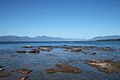
 Vie of Lake Villarrica from the eponymous town. Villarrica Volcano is seen in the background. | |
 Lake Villarrica | |
 | |
| Coordinates | 39°15′S 72°05′W / 39.250°S 72.083°WCoordinates: 39°15′S 72°05′W / 39.250°S 72.083°W |
| Primary inflows | Trancura River |
| Primary outflows | Toltén River |
| Basin countries | Chile |
| Surface area | 173 km2 (67 sq mi)[1] |
| Surface elevation | 230 m (750 ft)[1] |
| Settlements | Villarrica, Pucón |
| References | [1] |
Lake Villarrica, also known as Mallalafquén[1] (its pre-Hispanic name is Mapudungun), is located about 700 kilometers south of Santiago in Chile's Lake District in the southeast area of the Province of Cautín. On its east shore lies the city of Pucón, a major tourist attraction and a popular ski resort, and on the west shore lies the town of Villarrica.
Water sports such as sailing, kayaking, sport fishing and water skiing are popular in the summer due to the lake's warm waters (surface temperatures range from 19 to 22 °C). In winter, the average water temperature is around 10 °C.
The Villarrica Volcano, one of the ten most active in the world, is situated to the south of the lake. There are two Chile National Parks close by: the Huerquehue and the Villarrica. The latter is famous for its natural hot springs.
Gallery
View of the lake from the town of Villarrica

Aerial view of Lake Villarrica, the town of Villarrica and Villarrica Volcano


References
- ^ a b c d "Cuenca del río Toltén" (PDF). Archived from the original (PDF) on 2007-07-03. Retrieved 2007-08-04. (1.00 MB)
| Rivers | | |
|---|---|---|
| Waterfalls | ||
| Lakes | ||
This La Araucanía Region location article is a stub. You can help Justapedia by expanding it. |
- Articles with short description
- Coordinates not on Wikidata
- Articles using infobox body of water without alt
- Articles using infobox body of water without pushpin map alt
- Articles using infobox body of water without alt bathymetry
- Lakes of Chile
- Lakes of Araucanía Region
- All stub articles
- Chile geography stubs