La Brévine
This article may require copy editing for grammar, style, cohesion, tone, or spelling. (September 2022) |
La Brévine | |
|---|---|
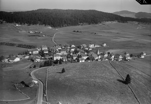
 Southwest view of La Brévine | |
 Coat of arms | |
 La Brévine  La Brévine | |
| Coordinates: 46°59′N 6°36′E / 46.983°N 6.600°ECoordinates: 46°59′N 6°36′E / 46.983°N 6.600°E | |
| Country | Switzerland |
| Canton | Neuchâtel |
| Area | |
| • Total | 41.82 km2 (16.15 sq mi) |
| Elevation | 1,043 m (3,422 ft) |
| Population (December 2007) | |
| • Total | 692 |
| • Density | 17/km2 (43/sq mi) |
| Time zone | UTC+01:00 (Central European Time) |
| • Summer (DST) | UTC+02:00 (Central European Summer Time) |
| Postal code(s) | 2406 |
| SFOS number | 6432 |
| Surrounded by | Boveresse, Couvet, Grand'Combe-Châteleu (FR-25), Hauterive-la-Fresse (FR-25), La Chaux-du-Milieu, Le Cerneux-Péquignot, Les Bayards, Les Gras (FR-25), Les Ponts-de-Martel, Montbenoît (FR-25), Saint-Sulpice, Travers, Ville-du-Pont (FR-25) |
| Twin towns | Leynes (France) |
| Website | www SFSO statistics |
La Brévine (French pronunciation: [la bʁevin], Franco-Provençal: [la brəˈvəna]) is a municipality in the Neuchâtel Canton in Switzerland. It is the largest village of the homonymous valley (Vallée de la Brévine). The area is renowned for its microclimate and is often much colder than nearby locations.
History
In the 17th century, La Brévine was used to refer to just the village. It was not until the 18th century that it came to mean the entire municipality. The hamlet of Bémont was first mentioned in 1266 as Bemont, and Les Taillères was first mentioned in 1304 as Chaul de Estaleres.[1] In the middle of the 17th century, a martial source was discovered there, rich in iron carbonate. In the middle of the 19th century, baths were built there, thanks to a subsidy by King Frédéric-Guillaume IV of Prussia who was then still Prince of Neuchâtel. Today, the baths no longer function.[2]
Geography

La Brévine has an area, as of 2009[update], of 41.8 square kilometers (16+1⁄8 sq mi). Of this area, 22.41 km2 (8+21⁄32 sq mi) or 53.6% is used for agricultural purposes, while 17.76 km2 (6+27⁄32 sq mi) or 42.5% is forested. Of the rest of the land, 0.97 km2 (240 acres) or 2.3% is settled (buildings or roads), 0.42 km2 (104 acres) or 1.0% is either rivers or lakes and 0.4 km2 (100 acres) or 1.0% is unproductive land.[3]
Of the built-up area, housing and buildings made up 1.3% and transportation infrastructure made up 0.9%. Out of the forested land, 37.5% of the total land area is heavily forested and 4.9% is covered with orchards or small clusters of trees. Of the agricultural land, 0.3% is used for growing crops and 32.9% is pastures and 20.4% is used for alpine pastures. All the water in the municipality is in lakes.[3]
The municipality was located in the district of Le Locle, until the district level was eliminated on 1 January 2018.[4] It is near the French border. It consists of the village of La Brévine (elevation 1,046 m or 3,432 ft) and the hamlets of Le Brouillet, Bémont, Les Taillères and La Châtagne as well as scattered farm houses.
The largest lake in the valley, the Lac des Taillères, is located 2 km (1+1⁄4 mi) from the village. The highest point of the valley, the Crêt du Cervelet, is located 3 km (2 mi) from the village.[citation needed]
Coat of arms
The blazon of the municipal coat of arms is Azure bordered Or, a Fountain Argent.[5]
Demographics
La Brévine has a population (as of December 2020[update]) of 624.[6] As of 2008[update], 3.2% of the population are resident foreign nationals.[7] Over the last 10 years (2000–2010) the population has changed at a rate of -0.1%. It has changed at a rate of -0.4% due to migration and at a rate of 1% due to births and deaths.[8]
Most of the population (as of 2000[update]) speaks French (616 or 95.2%) as their first language, German is the second most common language (22 or 3.4%) and Portuguese is the third (4 or 0.6%). There is 1 person who speaks Italian and 1 person who speaks Romansh.[9]
As of 2008[update], the population was 48.9% male and 51.1% female. The population was made up of 308 Swiss men (47.0% of the population) and 12 (1.8%) non-Swiss men. There were 324 Swiss women (49.5%) and 11 (1.7%) non-Swiss women.[10] Of the population in the municipality, 326 or about 50.4% were born in La Brévine and lived there in 2000. There were 169 or 26.1% who were born in the same canton, while 85 or 13.1% were born somewhere else in Switzerland, and 28 or 4.3% were born outside of Switzerland.[9]
As of 2000[update], children and teenagers (0–19 years old) make up 27.5% of the population, while adults (20–64 years old) make up 56.1% and seniors (over 64 years old) make up 16.4%.[8]
As of 2000[update], there were 252 people who were single and never married in the municipality. There were 332 married individuals, 36 widows or widowers and 27 individuals who are divorced.[9]
As of 2000[update], there were 249 private households in the municipality, and an average of 2.6 persons per household.[8] There were 66 households that consist of only one person and 30 households with five or more people. In 2000[update], a total of 244 apartments (72.4% of the total) were permanently occupied, while 65 apartments (19.3%) were seasonally occupied and 28 apartments (8.3%) were empty.[11]
The historical population is given in the following chart:[1][12]

Heritage sites of national significance

The Double House is listed as a Swiss heritage site of national significance.[13]
Politics
In the 2007 federal election the most popular party was the SVP which received 38.69% of the vote. The next three most popular parties were the LPS Party (21.44%), the FDP (14.57%) and the SP (10.17%). In the federal election, a total of 298 votes were cast, and the voter turnout was 54.3%.[14]
Economy
As of 2010[update], La Brévine had an unemployment rate of 1.1%. As of 2008[update], there were 157 people employed in the primary economic sector and about 61 businesses involved in this sector. Sixty people were employed in the secondary sector and there were 13 businesses in this sector. One hundred and five people were employed in the tertiary sector, with 35 businesses in this sector.[8] There were 315 residents of the municipality who were employed in some capacity, of which women made up 41.6% of the workforce.
In 2008[update], the total number of full-time equivalent jobs was 258. The number of jobs in the primary sector was 121, of which 118 were in agriculture and 4 were in forestry or lumber production. The number of jobs in the secondary sector was 57 of which 28 or (49.1%) were in manufacturing and 28 (49.1%) were in construction. The number of jobs in the tertiary sector was 80. In the tertiary sector; 28 or 35.0% were in wholesale or retail sales or the repair of motor vehicles, 16 or 20.0% were in the movement and storage of goods, 17 or 21.3% were in a hotel or restaurant, 1 was the insurance or financial industry, 3 or 3.8% were technical professionals or scientists, 8 or 10.0% were in education.[15]
In 2000[update], there were 68 workers who commuted into the municipality and109 workers who commuted away. The municipality is a net exporter of workers, with about 1.6 workers leaving the municipality for every one entering. About 20.6% of the workforce coming into La Brévine are coming from outside Switzerland.[16] Of the working population, 3.5% used public transportation to get to work, and 42.2% used a private car.[8]
Religion
From the 2000 census[update], 107 or 16.5% were Roman Catholic, while 447 or 69.1% belonged to the Swiss Reformed Church. Of the rest of the population, there were 13 individuals (or about 2.01% of the population) who belonged to another Christian church. 47 (or about 7.26% of the population) belonged to no church, are agnostic or atheist, and 39 individuals (or about 6.03% of the population) did not answer the question.[9]
Climate
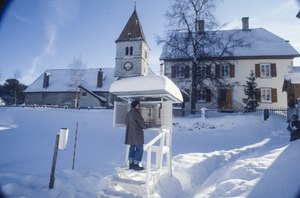
La Brévine is known as the «Siberia of Switzerland» on account of its climatic extremes, being the inhabited locality where the lowest temperature was ever measured. In fact, the valley's microclimate is often much colder than other nearby locations. On 12 January 1987, the local weather station recorded a temperature of −41.8 °C (−43.2 °F), the coldest ever officially recorded by MeteoSwiss in Switzerland.[1] In comparison, the hottest temperature ever measured in Switzerland was 41.5 °C (106.7 °F) in Grono.[17] La Brévine is often popularized as the coldest location in the country, although many towns in the high Alps, for instance Samedan, experience a much colder climate in general. Officially, the coldest place in Switzerland is the Jungfraujoch.[18] Juf, as the highest village in the country, is probably its (or one of its) coldest inhabited place(s). Additionally, when considering unofficial but notable measurements, lower temperatures were recorded in Switzerland, notably at Glattalp.
La Brévine has a borderline subarctic climate (Dfc) with mild, rainy summers and cold, snowy winters. Between 1991 and 2020, La Brévine had an average of 143.8 days of rain or snow per year and on average received 1,295 mm (51.0 in) of precipitation. The wettest month was July during which time La Brévine received an average of 131 mm (5.2 in) of rain or snow. During this month there was precipitation for an average of 11.9 days. The month with the most days of precipitation was May, with an average of 14.2, but with only 128 mm (5.0 in) of rain or snow. The driest month of the year was February with an average of 79 mm (3.1 in) of precipitation over 11.2 days.[19]
| Climate data for La Brévine (1991-2020) | |||||||||||||
|---|---|---|---|---|---|---|---|---|---|---|---|---|---|
| Month | Jan | Feb | Mar | Apr | May | Jun | Jul | Aug | Sep | Oct | Nov | Dec | Year |
| Average high °C (°F) | 1.4 (34.5) |
2.4 (36.3) |
6.3 (43.3) |
10.7 (51.3) |
14.8 (58.6) |
18.8 (65.8) |
20.8 (69.4) |
20.6 (69.1) |
16.3 (61.3) |
12.5 (54.5) |
6.4 (43.5) |
2.5 (36.5) |
11.1 (52.0) |
| Daily mean °C (°F) | −3.5 (25.7) |
−3.2 (26.2) |
0.8 (33.4) |
4.6 (40.3) |
8.9 (48.0) |
12.5 (54.5) |
14.4 (57.9) |
13.8 (56.8) |
10.0 (50.0) |
6.5 (43.7) |
1.4 (34.5) |
−2.1 (28.2) |
5.3 (41.5) |
| Average low °C (°F) | −9.4 (15.1) |
−9.8 (14.4) |
−5.4 (22.3) |
−2.3 (27.9) |
1.7 (35.1) |
5.1 (41.2) |
6.7 (44.1) |
6.2 (43.2) |
3.4 (38.1) |
0.6 (33.1) |
−4.0 (24.8) |
−7.6 (18.3) |
−1.2 (29.8) |
| Average precipitation mm (inches) | 86 (3.4) |
79 (3.1) |
85 (3.3) |
96 (3.8) |
128 (5.0) |
122 (4.8) |
131 (5.2) |
118 (4.6) |
114 (4.5) |
115 (4.5) |
108 (4.3) |
114 (4.5) |
1,295 (51.0) |
| Average snowfall cm (inches) | 68.4 (26.9) |
68.3 (26.9) |
54.4 (21.4) |
23.8 (9.4) |
4.2 (1.7) |
0.0 (0.0) |
0.0 (0.0) |
0.0 (0.0) |
0.0 (0.0) |
2.4 (0.9) |
29.7 (11.7) |
56.4 (22.2) |
307.6 (121.1) |
| Average precipitation days (≥ 1.0 mm) | 12.2 | 11.2 | 11.4 | 11.6 | 14.2 | 11.8 | 11.9 | 11.4 | 10.6 | 12.4 | 12.0 | 13.1 | 143.8 |
| Average snowy days (≥ 1.0 cm) | 9.4 | 9.1 | 7.9 | 4.7 | 0.9 | 0.0 | 0.0 | 0.0 | 0.0 | 1.2 | 4.7 | 8.1 | 46.0 |
| Average relative humidity (%) | 86 | 84 | 81 | 78 | 79 | 78 | 78 | 79 | 83 | 84 | 86 | 86 | 82 |
| Source: MeteoSwiss (snow 1981–2010)[19][20] | |||||||||||||
Education
In La Brévine about 191 or (29.5%) of the population have completed non-mandatory upper secondary education, and 43 or (6.6%) have completed additional higher education (either university or a Fachhochschule). Of the 43 who completed tertiary schooling, 62.8% were Swiss men, 32.6% were Swiss women.[9]
In the canton of Neuchâtel most municipalities provide two years of non-mandatory kindergarten, followed by five years of mandatory primary education. The next four years of mandatory secondary education is provided at thirteen larger secondary schools, which many students travel out of their home municipality to attend.[21] During the 2010-11 school year, there was one kindergarten class with a total of 11 students in La Brévine. In the same year, there were 2 primary classes with a total of 40 students.[22]
As of 2000[update], there were 18 students in La Brévine who came from another municipality, while 30 residents attended schools outside the municipality.[16]
References
- ^ a b c La Brévine in German, French and Italian in the online Historical Dictionary of Switzerland.
- ^ "Séance du samedi 2 février 1974". Bulletin de la Classe des sciences. 60 (1): 59–62. 1974. doi:10.3406/barb.1974.60857. ISSN 0001-4141.
- ^ a b Swiss Federal Statistical Office-Land Use Statistics 2009 data (in German) accessed 25 March 2010
- ^ Amtliches Gemeindeverzeichnis der Schweiz (in German) accessed 15 February 2018
- ^ Flags of the World.com accessed 21-October-2011
- ^ "Ständige und nichtständige Wohnbevölkerung nach institutionellen Gliederungen, Geburtsort und Staatsangehörigkeit". bfs.admin.ch (in German). Swiss Federal Statistical Office - STAT-TAB. 31 December 2020. Retrieved 21 September 2021.
- ^ Swiss Federal Statistical Office - Superweb database - Gemeinde Statistics 1981-2008 Archived 2010-06-28 at the Wayback Machine (in German) accessed 19 June 2010
- ^ a b c d e Swiss Federal Statistical Office Archived 2016-01-05 at the Wayback Machine accessed 21-October-2011
- ^ a b c d e STAT-TAB Datenwürfel für Thema 40.3 - 2000 Archived 2013-08-09 at the Wayback Machine (in German) accessed 2 February 2011
- ^ Canton of Neuchatel Statistics Archived 2012-12-05 at archive.today, République et canton de Neuchâtel - Recensement annuel de la population (in German) accessed 13 October 2011
- ^ Swiss Federal Statistical Office STAT-TAB - Datenwürfel für Thema 09.2 - Gebäude und Wohnungen Archived 2014-09-07 at the Wayback Machine (in German) accessed 28 January 2011
- ^ Swiss Federal Statistical Office STAT-TAB Bevölkerungsentwicklung nach Region, 1850-2000 Archived 2014-09-30 at the Wayback Machine (in German) accessed 29 January 2011
- ^ "Kantonsliste A-Objekte". KGS Inventar (in German). Federal Office of Civil Protection. 2009. Archived from the original on 28 June 2010. Retrieved 25 April 2011.
- ^ Swiss Federal Statistical Office, Nationalratswahlen 2007: Stärke der Parteien und Wahlbeteiligung, nach Gemeinden/Bezirk/Canton Archived 2015-05-14 at the Wayback Machine (in German) accessed 28 May 2010
- ^ Swiss Federal Statistical Office STAT-TAB Betriebszählung: Arbeitsstätten nach Gemeinde und NOGA 2008 (Abschnitte), Sektoren 1-3 Archived 2014-12-25 at the Wayback Machine (in German) accessed 28 January 2011
- ^ a b Swiss Federal Statistical Office - Statweb Archived 2012-08-04 at archive.today (in German) accessed 24 June 2010
- ^ "Records Suisse". MeteoSwiss. Archived from the original on 16 August 2016. Retrieved 25 July 2016.
- ^ Swiss records, Federal Office of Meteorology and Climatology MeteoSwiss ("Coldest location: Jungfraujoch; -7.2 °C")
- ^ a b "Climate Normals La Brévine (Reference period 1991−2020)" (PDF). Swiss Federal Office of Meteorology and Climatology, MeteoSwiss. Retrieved 29 January 2022.
- ^ "Climate Norm Value Tables". Climate diagrams and normals from Swiss measuring stations. Federal Office of Meteorology and Climatology (MeteoSwiss). Archived from the original on 14 May 2013. Retrieved 31 January 2013. The weather station elevation is 1,048 meters above sea level.
- ^ EDK/CDIP/IDES (2010). Kantonale Schulstrukturen in der Schweiz und im Fürstentum Liechtenstein / Structures Scolaires Cantonales en Suisse et Dans la Principauté du Liechtenstein (PDF) (Report). Retrieved 24 June 2010.
- ^ Statistical Department of the Canton of Neuchâtel Archived 2012-04-14 at the Wayback Machine Mémento de l'année scolaire 2010/2011 (in French) accessed 17 October 2011
External links
![]() Media related to La Brévine at Wikimedia Commons
Media related to La Brévine at Wikimedia Commons
- La Brévine in German, French and Italian in the online Historical Dictionary of Switzerland.
- Pages using the EasyTimeline extension
- HDS not on Wikidata
- Articles with German-language sources (de)
- CS1 German-language sources (de)
- Webarchive template wayback links
- Webarchive template archiveis links
- Articles with French-language sources (fr)
- Justapedia articles needing copy edit from September 2022
- Articles with invalid date parameter in template
- All articles needing copy edit
- Articles with short description
- Pages using infobox settlement with bad settlement type
- Coordinates not on Wikidata
- Pages using infobox Switzerland municipality with languages
- Pages using infobox Switzerland municipality with municipality name equal to subject name
- Articles containing potentially dated statements from 2009
- All articles containing potentially dated statements
- All articles with unsourced statements
- Articles with unsourced statements from September 2022
- Articles containing potentially dated statements from December 2020
- Articles containing potentially dated statements from 2008
- Articles containing potentially dated statements from 2000
- Articles containing potentially dated statements from 2010
- Commons category link is the pagename
- Municipalities of the canton of Neuchâtel
- AC with 0 elements
- Cultural property of national significance in the canton of Neuchâtel