Utah State Route 64
State Route 64 | ||||
|---|---|---|---|---|
 | ||||
| Route information | ||||
| Maintained by UDOT | ||||
| Length | 2.015 mi[1] (3.243 km) | |||
| Existed | 1975–present | |||
| Major junctions | ||||
| South end | ||||
| North end | ||||
| Location | ||||
| Country | United States | |||
| State | Utah | |||
| Highway system | ||||
| ||||
| ||||

State Route 64 (SR-64) is a state highway in the U.S. state of Utah that serves as a connection from US-50 in the town of Holden to I-15, which bypasses the town. The route is a remnant of old US-91, bypassed by I-15.
Route description
The road begins from the ramps connecting exit 174 on I-15 and heads northwest, and then turns northeast on the west-side frontage road, continuing north to serve as the Main Street of Holden. At the northern outskirts of the town, the highway terminates at US-50.[2]
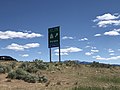
Southern end of SR64, as seen from southbound I-15. Signage on the northbound side of the freeway includes a reference to WEST US 50 (May 2020)

Approaching northern end of SR64. Eastbound US 50 arrives at a T-intersection at the edge of Holden and turns left, and the SR 64 is to the right (May 2020)

Signage at the T-intersection in Holden. This is the northern end of SR64, but the BGS simply points the way to Interstate 15 (May 2020)


History
Holden's Main Street became a state highway in 1910 as part of the main road south-southwesterly from Salt Lake City.[3] It was numbered as part of SR-1 and US-91 in the 1920s.[4] In 1969, with the construction of I-15 imminent, State Route 26 (now US-50), which had ended at SR-1 just north of Holden, was extended both north and south from its eastern end to meet I-15 on both sides of the bypass.[5] The state legislature redesignated the southern half as SR-64 in 1975,[6] about a year before I-15 was completed in the area.[7]
Major intersections
The entire route is in Millard County.
| Location | mi[1] | km | Destinations | Notes | |
|---|---|---|---|---|---|
| | 0.000– 0.136 | 0.000– 0.219 | Southern terminus | ||
| Holden | 2.015 | 3.243 | Northern terminus | ||
| 1.000 mi = 1.609 km; 1.000 km = 0.621 mi | |||||
References
Route map:
- ^ a b "Highway Reference Information - Route 0064" (PDF). Utah Department of Transportation. Retrieved 2008-07-23.
- ^ "Google Maps". Google.
- ^ Utah Department of Transportation, Highway Resolutions: "Route 1". (35.4 MB), updated September 2007, accessed May 2008
- ^ Rand McNally Auto Road Atlas, 1926
- ^ Utah Department of Transportation, Highway Resolutions: "Route 26". (4.54 MB), updated September 2007, accessed May 2008
- ^ Utah Department of Transportation, Highway Resolutions: "Route 64". (645 KB), updated November 2007, accessed May 2008
- ^ Federal Highway Administration, National Bridge Inventory database, 2007