Upper Fairmount, Maryland
Jump to navigation
Jump to search
Upper Fairmount, Maryland | |
|---|---|
 Christ United Methodist Church | |
 Upper Fairmount | |
| Coordinates: 38°06′14″N 75°47′29″W / 38.10389°N 75.79139°WCoordinates: 38°06′14″N 75°47′29″W / 38.10389°N 75.79139°W | |
| Country | |
| State | |
| County | |
| Elevation | 0.9 m (3 ft) |
| Time zone | UTC-5 (Eastern (EST)) |
| • Summer (DST) | UTC-4 (EDT) |
| ZIP code | 21867 |
| Area code(s) | 410, 443, and 667 |
| GNIS feature ID | 591458[1] |
Upper Fairmount is an unincorporated community in Somerset County, Maryland, United States.[1] It is located at the intersection of Maryland Route 361 (Fairmount Road) and Upper Hill Road. The Academy Grove Historic District, Maddux House, Schoolridge Farm, Tudor Hall, and Upper Fairmount Historic District are listed on the National Register of Historic Places.[2]
References
Municipalities and communities of Somerset County, Maryland, United States | ||
|---|---|---|
| City | 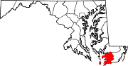 | |
| Town | ||
| CDPs | ||
| Other communities | ||
Categories:
- Articles using NRISref without a reference number
- Articles with short description
- Short description with empty Wikidata description
- Coordinates not on Wikidata
- Pages using infobox settlement with possible area code list
- AC with 0 elements
- Unincorporated communities in Somerset County, Maryland
- Unincorporated communities in Maryland
- Maryland populated places on the Chesapeake Bay
- All stub articles
- Somerset County, Maryland geography stubs