Tsovak
Jump to navigation
Jump to search
Tsovak
Ծովակ | |
|---|---|
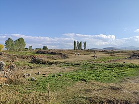
 A view of Tsovak | |
 Tsovak  Tsovak | |
| Coordinates: 40°10′58″N 45°38′02″E / 40.18278°N 45.63389°ECoordinates: 40°10′58″N 45°38′02″E / 40.18278°N 45.63389°E | |
| Country | |
| Province | Gegharkunik |
| Elevation | 1,920 m (6,300 ft) |
| Population | |
| • Total | 2,319 |
| Time zone | UTC+4 (AMT) |
| Postal code | 1612 |
| Tsovak at GEOnet Names Server | |
Tsovak (Armenian: Ծովակ) is a village in the Gegharkunik Province of Armenia.
Toponymy
The village was previously known as Nerkin Zagalu and Nizhniy Zagalu.
History
The village is the site of a large Iron Age fort atop the hill to the south and west, with an 8th-century BCE cuneiform inscription of Sarduri II cut into the stone at the north edge of the fortification.[2]
Gallery

Khachkars in Tsovak
Tsovak castle

Yot Axper chapel
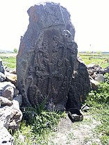
Khachkar in Yot Axper chapel
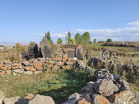
Yot Axper chapel


References
- ^ Statistical Committee of Armenia. "The results of the 2011 Population Census of Armenia" (PDF).
- ^ Kiesling, Brady; Kojian, Raffi (2005). Rediscovering Armenia: Guide (2nd ed.). Yerevan: Matit Graphic Design Studio. p. 81. ISBN 99941-0-121-8.
External links
Wikimedia Commons has media related to Tsovak.
- World Gazeteer: Armenia[dead link] – World-Gazetteer.com
- Report of the results of the 2001 Armenian Census, Statistical Committee of Armenia
- Brady Kiesling, Rediscovering Armenia, p. 47; original archived at Archive.org, and current version online on Armeniapedia.org.

This article about a location in Gegharkunik Province, Armenia is a stub. You can help Justapedia by expanding it. |
Categories:
- Articles with short description
- Short description with empty Wikidata description
- Coordinates not on Wikidata
- Articles containing Armenian-language text
- Commons link is the pagename
- All articles with dead external links
- Articles with dead external links from July 2021
- Populated places in Gegharkunik Province
- All stub articles
- Gegharkunik geography stubs