Timeline of the 2022 Atlantic hurricane season
| Timeline of the 2022 Atlantic hurricane season | |||||
|---|---|---|---|---|---|
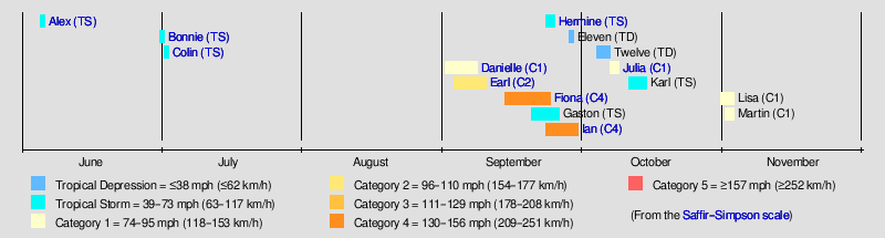
 Season summary map | |||||
| Season boundaries | |||||
| First system formed | June 5, 2022 | ||||
| Last system dissipated | Season ongoing | ||||
| Strongest system | |||||
| Name | Fiona[nb 1] | ||||
| Maximum winds | 130 mph (215 km/h) (1-minute sustained) | ||||
| Lowest pressure | 932 mbar (hPa; 27.52 inHg) | ||||
| Longest lasting system | |||||
| Name | Fiona | ||||
| Duration | 9.5 days | ||||
|
| |||||
The 2022 Atlantic hurricane season is the current cycle of the annual tropical cyclone season in the Atlantic Ocean in the Northern Hemisphere. The season officially began on June 1, and will end on November 30. These dates, adopted by convention, historically describe the period in each year when most subtropical or tropical cyclogenesis occurs in the Atlantic Ocean (over 97%).[1] No subtropical or tropical development occurred in the Atlantic prior to the start of the season, making this the first since 2014 not to have a pre-season named storm.[2] The season's first storm, Tropical Storm Alex, formed on June 5. Altogether, fourteen tropical cyclones have developed so far this season, twelve of which became named storms. Seven of these became hurricanes, with two reaching major hurricane strength (Category 3 or higher on the Saffir–Simpson scale).
This timeline documents tropical cyclone formations, strengthening, weakening, landfalls, extratropical transitions, and dissipations during the season. It includes information that was not released throughout the season, meaning that data from post-storm reviews by the National Hurricane Center, such as a storm that was not initially warned upon, has been included.
By convention, meteorologists use one time zone when issuing forecasts and making observations: Coordinated Universal Time (UTC), and also use the 24-hour clock (where 00:00 = midnight UTC).[3] The National Hurricane Center uses both UTC and the time zone where the center of the tropical cyclone is currently located. The time zones utilized (east to west) are: Greenwich, Cape Verde, Atlantic, Eastern, and Central.[4] In this timeline, all information is listed by UTC first, with the respective regional time zone included in parentheses. Additionally, figures for maximum sustained winds and position estimates are rounded to the nearest 5 units (knots, miles, or kilometers), following National Hurricane Center practice. Direct wind observations are rounded to the nearest whole number. Atmospheric pressures are listed to the nearest millibar and nearest hundredth of an inch of mercury.
Timeline of events
June
June 1
- The 2022 Atlantic hurricane season officially begins.[1]
June 5

- 00:00 UTC (8:00 p.m. EDT, June 4) at 28°00′N 78°48′W / 28.0°N 78.8°W – Tropical Storm Alex forms from a low-pressure system about 85 mi (140 km) north of Grand Bahama Island.[nb 2][6]
- 18:00 UTC (2:00 p.m. EDT) at 31°00′N 72°30′W / 31.0°N 72.5°W – Tropical Storm Alex reaches its peak sustained winds of 70 mph (110 km/h) about 345 mi (555 km) south-southeast of Cape Hatteras, North Carolina.[6]
June 6
- 00:00 UTC (8:00 p.m. AST, June 5) at 32°06′N 70°12′W / 32.1°N 70.2°W – Tropical Storm Alex reaches a minimum central pressure of 984 mbar (29.06 inHg) about 320 mi (520 km) west of Bermuda.[6]
- 12:00 UTC (8:00 a.m. AST) at 33°48′N 65°12′W / 33.8°N 65.2°W – Tropical Storm Alex transitions to a post-tropical cyclone about 105 mi (165 km) north-northwest of Bermuda, and is later absorbed within a baroclinic zone.[6]
July
July 1
- 13:15 UTC (9:15 a.m. EDT) at 11°12′N 80°30′W / 11.2°N 80.5°W – Tropical Storm Bonnie forms from an area of low pressure about 230 mi (370 km) east-southeast of Bluefields, Nicaragua.[nb 3][8]
July 2
- 03:00 UTC (11:00 p.m. EDT, July 1) at 10°54′N 83°48′W / 10.9°N 83.8°W – Tropical Storm Bonnie makes landfall near the Costa Rica–Nicaragua border with winds of 50 mph (85 km/h),[nb 4] about 75 mi (120 km) south of Bluefields, Nicaragua.[9]
- 09:00 UTC (5:00 a.m. EDT) at 33°12′N 79°30′W / 33.2°N 79.5°W – Tropical Storm Colin forms from a low-pressure system about 50 mi (80 km) southwest of Myrtle Beach, South Carolina and simultaneously reaches peak intensity with maximum sustained winds of 40 mph (65 km/h) and a minimum central pressure of 1011 mbar (29.85 inHg).[10]
- 12:00 UTC (7:00 a.m. CDT) at 11°12′N 85°48′W / 11.2°N 85.8°W – Tropical Storm Bonnie approaches the Pacific coast of Nicaragua, about 65 mi (105 km) southeast of Managua, Nicaragua,[11] and then exits the Atlantic basin a few hours later.[12]
July 3
- 03:00 UTC (11:00 p.m. EDT, July 2) at 34°24′N 77°48′W / 34.4°N 77.8°W – Tropical Storm Colin weakens to a tropical depression about 15 mi (25 km) north of Wilmington, North Carolina.[13]
- 09:00 UTC (5:00 a.m. EDT) at 35°12′N 77°00′W / 35.2°N 77.0°W – Tropical Depression Colin dissipates about 10 mi (15 km) north-northeast of New Bern, North Carolina.[14]
August
No tropical cyclones formed in the basin during the month of August.[nb 5][16]
September
September 1
- 09:00 UTC (5:00 a.m. AST) at 38°06′N 45°00′W / 38.1°N 45.0°W – Tropical Depression Five forms from an area of low pressure about 975 mi (1575 km) west of the Azores.[17]
- 15:00 UTC (3:00 p.m. GMT) at 38°06′N 44°42′W / 38.1°N 44.7°W – Tropical Depression Five strengthens into Tropical Storm Danielle about 960 mi (1545 km) west of the Azores.[18]
September 2
- 15:00 UTC (3:00 p.m. GMT) at 37°54′N 43°18′W / 37.9°N 43.3°W – Tropical Storm Danielle strengthens into a Category 1 hurricane about 885 mi (1425 km) west of the Azores.[19]
September 3
- 03:00 UTC (11:00 p.m. AST, September 2) at 18°24′N 60°18′W / 18.4°N 60.3°W – Tropical Storm Earl forms from a low-pressure system about 185 mi (295 km) east of the northern Leeward Islands.[20]
- 09:00 UTC (9:00 a.m. GMT) at 38°00′N 43°48′W / 38.0°N 43.8°W – Hurricane Danielle weakens to a tropical storm about 915 mi (1470 km) west of the Azores.[21]
September 4
- 03:00 UTC (11:00 p.m. AST, September 3) at 38°06′N 45°06′W / 38.1°N 45.1°W – Tropical Storm Danielle re-strengthens into a Category 1 hurricane about 985 mi (1580 km) west of the Azores.[22]
September 5

- 03:00 UTC (3:00 a.m. GMT) at 39°00′N 44°42′W / 39.0°N 44.7°W – Hurricane Danielle attains peak sustained winds of 90 mph (150 km/h) about 955 mi (1540 km) west of the Azores.[23]
September 7
- 00:00 UTC (8:00 p.m. AST, September 6) at 24°24′N 65°48′W / 24.4°N 65.8°W – Tropical Storm Earl intensifies into a Category 1 hurricane about 550 mi (885 km) south of Bermuda.[24]
- 15:00 UTC (3:00 p.m. GMT) at 43°42′N 36°18′W / 43.7°N 36.3°W – Hurricane Danielle attains a minimum barometric pressure of 972 mbar (28.71 inHg) about 625 mi (1005 km) northwest of the Azores.[25]
September 8
- 03:00 UTC (11:00 p.m. AST, September 7) at 27°12′N 65°30′W / 27.2°N 65.5°W – Hurricane Earl intensifies into a Category 2 hurricane about 355 mi (570 km) south of Bermuda.[26]
- 09:00 UTC (9:00 a.m. GMT) at 46°48′N 32°00′W / 46.8°N 32.0°W – Hurricane Danielle weakens to a tropical storm about 660 mi (1060 km) north-northwest of the Azores.[27]
- 15:00 UTC (3:00 p.m. GMT) at 47°54′N 31°00′W / 47.9°N 31.0°W – Tropical Storm Danielle transitions into a post-tropical cyclone about 715 mi (1145 km) north-northwest of the Azores.[28]
September 9
- 03:00 UTC (11:00 p.m. AST, September 8) at 31°18′N 63°42′W / 31.3°N 63.7°W – Hurricane Earl weakens to a Category 1 hurricane about 95 mi (150 km) southeast of Bermuda.[29]
- 09:00 UTC (5:00 a.m. AST) at 32°42′N 62°24′W / 32.7°N 62.4°W – Hurricane Earl re-strengthens to a Category 2 hurricane about 140 mi (230 km) east-northeast of Bermuda.[30]
- 21:00 UTC (5:00 p.m. AST) at 35°54′N 58°42′W / 35.9°N 58.7°W – Hurricane Earl attains peak intensity with maximum sustained winds of 105 mph (165 km/h) and a minimum barometric pressure of 954 mbar (28.17 inHg) about 430 mi (690 km) northeast of Bermuda.[31]
September 10
- 15:00 UTC (11:00 a.m. AST) at 42°54′N 53°00′W / 42.9°N 53.0°W – Hurricane Earl weakens to a Category 1 hurricane about 260 mi (420 km) south of Cape Race, Newfoundland.[32]
- 21:00 UTC (5:00 p.m. AST) at 43°36′N 52°36′W / 43.6°N 52.6°W – Hurricane Earl transitions into a hurricane-force extratropical low about 215 mi (345 km) south of Cape Race.[33]
September 14
- 15:00 UTC (11:00 a.m. AST) at 16°36′N 49°36′W / 16.6°N 49.6°W – Tropical Depression Seven forms about 805 mi (1300 km) east of the Leeward Islands.[34]
September 15
- 01:45 UTC (9:45 p.m. AST, September 14) at 16°48′N 52°00′W / 16.8°N 52.0°W – Tropical Depression Seven strengthens into Tropical Storm Fiona about 645 mi (1040 km) east of the Leeward Islands.[35]
September 18
- 15:00 UTC (11:00 a.m. AST) at 17°18′N 66°30′W / 17.3°N 66.5°W – Tropical Storm Fiona strengthens into a Category 1 hurricane about 50 mi (80 km) south of Ponce, Puerto Rico.[36]
- 19:20 UTC (3:20 p.m. AST) at 18°00′N 67°06′W / 18.0°N 67.1°W – Hurricane Fiona makes landfall about 15 mi (25 km) south-southeast of Mayaguez, Puerto Rico with maximum sustained winds of 85 mph (140 km/h).[37]
September 19
- 07:30 UTC (3:30 a.m. AST) at 18°24′N 68°30′W / 18.4°N 68.5°W – Hurricane Fiona makes landfall about 15 mi (25 km) south-southwest of Punta Cana, Dominican Republic, with maximum sustained winds of 90 mph (150 km/h).[38]
- 21:00 UTC (5:00 p.m. AST) at 20°06′N 69°48′W / 20.1°N 69.8°W – Hurricane Fiona intensifies into a Category 2 hurricane about 130 mi (205 km) southeast of Grand Turk Island.[39]
September 20
- 06:00 UTC (2:00 a.m. EDT) at 20°54′N 70°48′W / 20.9°N 70.8°W – Hurricane Fiona intensifies into a Category 3 hurricane about 45 mi (70 km) south-southeast of Grand Turk.[40]
- 15:00 UTC (11:00 a.m. AST) at 32°48′N 45°42′W / 32.8°N 45.7°W – Tropical Depression Eight forms about 1110 mi (1785 km) west-southwest of the Azores.[41]
- 21:00 UTC (9:00 p.m. GMT) at 34°42′N 44°24′W / 34.7°N 44.4°W – Tropical Depression Eight strengthens into Tropical Storm Gaston about 990 mi (1595 km) west of the Azores.[42]
September 21
- 06:00 UTC (2:00 a.m. EDT) at 23°24′N 71°48′W / 23.4°N 71.8°W – Hurricane Fiona intensifies into a Category 4 hurricane about 105 mi (170 km) north of North Caicos Island.[43]
September 23

- 00:00 UTC (8:00 p.m. AST, September 22) at 30°48′N 69°06′W / 30.8°N 69.1°W – Hurricane Fiona attains peak intensity with maximum sustained winds of 130 mph (215 km/h) and a minimum barometric pressure of 932 mbar (27.52 inHg) about 280 mi (455 km) west-southwest of Bermuda.[44]
- 09:00 UTC (5:00 a.m. AST) at 33°48′N 66°48′W / 33.8°N 66.8°W – Hurricane Fiona weakens to a Category 3 hurricane about 155 mi (250 km) northwest of Bermuda.[45]
- 09:00 UTC (5:00 a.m. AST) at 13°54′N 68°36′W / 13.9°N 68.6°W – Tropical Depression Nine forms about 615 mi (985 km) east-southeast of Kingston, Jamaica.[46]
- 15:00 UTC (11:00 a.m. AST) at 35°54′N 64°12′W / 35.9°N 64.2°W – Hurricane Fiona re-strengthens into a Category 4 hurricane about 250 mi (405 km) north of Bermuda.[47]
- 15:00 UTC (3:00 p.m. GMT) at 40°12′N 29°06′W / 40.2°N 29.1°W – Tropical Storm Gaston attains peak intensity with maximum sustained winds of 65 mph (100 km/h) and a minimum barometric pressure of 995 mbar (28.17 inHg) about 115 mi (180 km) north of Faial Island in the Central Azores.[48]
- 15:00 UTC (2:00 p.m. CVT) at 17°54′N 19°48′W / 17.9°N 19.8°W – Tropical Depression Ten forms about 305 mi (495 km) east-northeast of Cape Verde.[49]
- 21:00 UTC (5:00 p.m. AST) at 39°36′N 61°00′W / 39.6°N 61.0°W – Hurricane Fiona weakens to a Category 3 hurricane about 370 mi (595 km) south-southeast of Halifax, Nova Scotia.[50]
- 21:00 UTC (8:00 p.m. CVT) at 18°36′N 20°30′W / 18.6°N 20.5°W – Tropical Depression Ten strengthens into Tropical Storm Hermine about 290 mi (470 km) northeast of Cape Verde.[51]
September 24
- 03:00 UTC (11:00 p.m. AST, September 23) at 44°30′N 60°48′W / 44.5°N 60.8°W – Hurricane Fiona transitions into a post-tropical cyclone with Category 2-strength winds about 140 mi (220 km) east of Halifax;[52] hours later it makes landfall in eastern Nova Scotia and then on Cape Breton Island with hurricane strength winds.[53]
- 03:00 UTC (11:00 p.m. EDT, September 23) at 14°48′N 72°00′W / 14.8°N 72.0°W – Tropical Depression Nine strengthens into Tropical Storm Ian about 385 mi (625 km) southeast of Kingston.[54]
- 21:00 UTC (8:00 p.m. CVT) at 21°48′N 20°36′W / 21.8°N 20.6°W – Tropical Storm Hermine weakens into a tropical depression about 460 mi (735 km) north-northeast of Cape Verde.[55]
September 25
- 09:00 UTC (8:00 a.m. CVT) at 23°36′N 20°12′W / 23.6°N 20.2°W – Tropical Depression Hermine transitions into a post-tropical remnant low about 580 mi (935 km) north-northeast of Cabo Verde;[56]
September 26
- 03:00 UTC (3:00 a.m. GMT) at 38°36′N 38°12′W / 38.6°N 38.2°W – Tropical Storm Gaston transitions into a post-tropical remnant low about 510 mi (825 km) west of Faial Island.[57]
- 09:00 UTC (5:00 a.m. EDT) at 18°12′N 82°00′W / 18.2°N 82.0°W – Tropical Storm Ian strengthens into a Category 1 hurricane about 90 mi (150 km) southwest of Grand Cayman.[58]
- 21:00 UTC (5:00 p.m. EDT) at 20°18′N 83°12′W / 20.3°N 83.2°W – Hurricane Ian strengthens into a Category 2 hurricane about 155 mi (250 km) southeast of the western tip of Cuba.[59]
September 27
- 06:30 UTC (2:30 a.m. EDT) at 21°54′N 83°36′W / 21.9°N 83.6°W – Hurricane Ian strengthens into a Category 3 hurricane about 35 mi (55 km) south of Pinar del Río, Cuba.[60]
- 08:30 UTC (4:30 a.m. EDT) at 21°54′N 83°36′W / 21.9°N 83.6°W – Hurricane Ian makes landfall near La Coloma, Cuba, with sustained winds of 125 mph (205 km/h).[61]
September 28

- 02:00 UTC (10:00 p.m. EDT, September 27) at 24°36′N 82°54′W / 24.6°N 82.9°W – Hurricane Ian passes directly over Dry Tortugas National Park in the Florida Keys with sustained winds of 120 mph (195 km/h).[62]
- 09:00 UTC (5:00 a.m. EDT) at 25°36′N 82°54′W / 25.6°N 82.9°W – Hurricane Ian intensifies into a Category 4 hurricane about 75 mi (125 km) west-southwest of Naples, Florida.[63]
- 10:35 UTC (6:35 a.m. EDT) at 25°54′N 82°48′W / 25.9°N 82.8°W – Hurricane Ian attains peak intensity with maximum sustained winds of 155 mph (250 km/h) and a minimum barometric pressure of 936 mbar (27.64 inHg) about 65 mi (105 km) west-southwest of Naples.[64]
- 15:00 UTC (11:00 a.m. AST) at 16°06′N 34°24′W / 16.1°N 34.4°W – Tropical Depression Eleven forms about 690 mi (1110 km) west of Cabo Verde.[65]
- 19:10 UTC (3:10 p.m. EDT) at 26°42′N 82°12′W / 26.7°N 82.2°W – Hurricane Ian makes landfall at Cayo Costa Island, Florida, with maximum sustained winds of 150 mph (240 km/h).[66]
- 20:35 UTC (4:35 p.m. EDT) at 26°48′N 82°00′W / 26.8°N 82.0°W – Hurricane Ian makes landfall on mainland Florida, about 10 mi (15 km) west-southwest of Punta Gorda, with maximum sustained winds of 145 mph (230 km/h).[67]
- 23:00 UTC (7:00 p.m. EDT) at 27°06′N 81°48′W / 27.1°N 81.8°W – Hurricane Ian weakens to a Category 3 hurricane inland about 25 mi (40 km) northeast of Punta Gorda.[68]
September 29
- 01:00 UTC (9:00 p.m. EDT, September 28) at 27°18′N 81°36′W / 27.3°N 81.6°W – Hurricane Ian weakens to a Category 2 hurricane inland about 40 mi (65 km) northeast of Punta Gorda.[69]
- 03:00 UTC (11:00 p.m. EDT, September 28) at 27°30′N 81°24′W / 27.5°N 81.4°W – Hurricane Ian weakens to a Category 1 hurricane inland about 70 mi (115 km) south of Orlando, Florida.[70]
- 09:00 UTC (5:00 a.m. EDT) at 28°00′N 80°54′W / 28.0°N 80.9°W – Hurricane Ian weakens to a tropical storm inland about 40 mi (65 km) southeast of Orlando.[71]
- 21:00 UTC (5:00 p.m. EDT) at 29°18′N 79°54′W / 29.3°N 79.9°W – Tropical Storm Ian re-strengthens into a Category 1 hurricane about 240 mi (385 km) south of Charleston, South Carolina.[72]
- 21:00 UTC (5:00 p.m. EDT) at 19°06′N 38°06′W / 19.1°N 38.1°W – Tropical Depression Eleven degenerates into a post-tropical remnant low about 950 mi (1530 km) west-northwest of Cabo Verde.[73]
September 30
- 18:05 UTC (2:05 p.m. EDT) at 33°18′N 79°12′W / 33.3°N 79.2°W – Hurricane Ian attains a secondary peak intensity with maximum sustained winds of 85 mph (140 km/h) and a minimum barometric pressure of 977 mbar (28.85 inHg) as it simultaneously makes landfall near Georgetown, South Carolina, about 55 mi (90 km) northeast of Charleston.[74]
- 21:00 UTC (5:00 p.m. EDT) at 33°54′N 79°12′W / 33.9°N 79.2°W – Hurricane Ian transitions into a post-tropical cyclone inland with tropical storm-strength winds about 20 mi (30 km) northwest of Myrtle Beach, South Carolina.[75]
October
October 4
- 21:00 UTC (5:00 p.m. AST) at 14°54′N 30°30′W / 14.9°N 30.5°W – Tropical Depression Twelve forms about 440 mi (705 km) west of Cabo Verde.[76]
October 7
- 03:00 UTC (11:00 p.m. AST, October 6) at 18°36′N 36°48′W / 18.6°N 36.8°W – Tropical Depression Twelve dissipates about 860 mi (1390 km) west-northwest of Cabo Verde.[77]
- 03:00 UTC (11:00 p.m. AST, October 6) at 11°54′N 69°48′W / 11.9°N 69.8°W – Tropical Depression Thirteen forms about 60 mi (100 km) west-southwest of Curaçao.[nb 6][79]
- 15:00 UTC (11:00 a.m. AST) at 12°42′N 73°06′W / 12.7°N 73.1°W – Tropical Depression Thirteen strengthens into Tropical Storm Julia about 110 mi (175 km) West of the northern tip of the Guajira Peninsula.[80]
October 8
- 23:00 UTC (7:00 p.m. EDT) at 12°30′N 81°42′W / 12.5°N 81.7°W – Tropical Storm Julia strengthens into a Category 1 hurricane about 10 mi (15 km) south of San Andres.[81]
October 9

- 07:15 UTC (3:15 a.m. EDT) at 12°24′N 83°36′W / 12.4°N 83.6°W – Hurricane Julia makes landfall near Laguna de Perlas, Nicaragua, about 30 mi (50 km) north-northeast of Bluefields, Nicaragua, with maximum sustained winds of 85 mph (140 km/h).[82]
- 15:00 UTC (10:00 a.m. CDT) at 12°24′N 85°24′W / 12.4°N 85.4°W – Hurricane Julia weakens to a tropical storm inland about 65 mi (105 km/h) east-northeast of Managua, Nicaragua.[83]
- 21:00 UTC (4:00 p.m. CDT) at 12°24′N 86°54′W / 12.4°N 86.9°W – Tropical Storm Julia approaches the Pacific coast of Nicaragua, about 45 mi (70 km) west-northwest of Managua,[84] and then exits the Atlantic basin a few hours later.[85]
October 11
- 21:00 UTC (4:00 p.m. CDT) at 19°36′N 94°24′W / 19.6°N 94.4°W – Tropical Storm Karl forms about 120 mi (195 km) east-northeast of Veracruz, Veracruz.[86]
October 12
- 17:35 UTC (12:35 p.m. CDT) at 22°00′N 94°30′W / 22.0°N 94.5°W – Tropical Storm Karl attains maximum sustained winds of 60 mi (95 km/h) about 200 mi (320 km) east-northeast of Veracruz.[87]
October 14
- 03:00 UTC (10:00 p.m. CDT, October 13) at 20°36′N 92°48′W / 20.6°N 92.8°W – Tropical Storm Karl attains a minimum barometric pressure of 998 mbar (29.47 inHg) about 155 mi (245 km/h) north-northwest of Ciudad del Carmen, Campeche.[88]
October 15
- 03:00 UTC (10:00 p.m. CDT, October 14) at 19°06′N 92°48′W / 19.1°N 92.8°W – Tropical Storm Karl weakens to a tropical depression about 75 mi (120 km/h) west-northwest of Ciudad del Carmen.[89]
- 09:00 UTC (4:00 a.m. CDT) at 18°36′N 93°00′W / 18.6°N 93.0°W – Tropical Depression Karl transitions to a post-tropical cyclone about 80 mi (125 km/h) west of Ciudad del Carmen.[90]
October 31
- 15:00 UTC (11:00 a.m. EDT) at 15°30′N 77°18′W / 15.5°N 77.3°W – Tropical Storm Lisa forms about 175 mi (285 km) south of Kingston, Jamaica.[nb 7][92]
November
November 1
- 15:00 UTC (11:00 a.m. AST) at 35°18′N 55°54′W / 35.3°N 55.9°W – Tropical Storm Martin forms about 550 mi (885 km) east-northeast of Bermuda.[93]
November 2
- 12:00 UTC (7:00 a.m. CDT) at 17°12′N 86°42′W / 17.2°N 86.7°W – Tropical Storm Lisa strengthens into a Category 1 hurricane about 60 mi (100 km) north of Isla Roatan, Honduras.[94]
- 15:00 UTC (11:00 a.m. AST) at 35°00′N 50°00′W / 35.0°N 50.0°W – Tropical Storm Martin strengthens into a Category 1 hurricane about 790 mi (1270 km) south-southeast of Cape Race, Newfoundland.[95]
- 21:20 UTC (4:20 p.m. CDT) at 17°24′N 88°18′W / 17.4°N 88.3°W – Hurricane Lisa makes landfall about 10 mi (15 km) southwest of Belize City, Belize, near the mouth of the Sibun River, with sustained winds of 85 mph (140 km/h).[96]
November 3
- 03:00 UTC (10:00 p.m. CDT, November 2, 2022) at 17°36′N 89°06′W / 17.6°N 89.1°W – Hurricane Lisa weakens to a tropical storm inland about 60 mi (95 km) west of Belize City.[97]
- 15:00 UTC (10:00 a.m. CDT) at 18°00′N 91°00′W / 18.0°N 91.0°W – Tropical Storm Lisa weakens to a tropical depression inland about 65 mi (110 km) southeast of Ciudad del Carman, Campeche.[98]
- 21:00 UTC (9:00 p.m. GMT) at 50°30′N 34°30′W / 50.5°N 34.5°W – Hurricane Martin transitions into a post-tropical cyclone about 885 mi (1425 km) east-northeast of Cape Race.[99]
November 30
- The 2022 Atlantic hurricane season officially ends.[1]
See also
- Timeline of the 2022 Pacific hurricane season
- Tropical cyclones in 2022
- Lists of Atlantic hurricanes
Notes
- ^ The "strength" of a tropical cyclone is measured by the lowest barometric pressure attained, not maximum wind speed. Most meteorological organizations rate the intensity of a storm by this figure, so the lower the minimum pressure of the storm, the more intense or "stronger" it is considered to be. The strongest winds were actually from Ian, at 155 mph (250 km/h).
- ^ Due to the threat the developing system posed to Cuba and Florida, the National Hurricane Center initiated advisories on it, designating it Potential Tropical Cyclone One at 21:00 UTC (4:00 p.m. CDT) on June 2.[5]
- ^ Due to the threat the developing system posed to the southern Windward Islands, the National Hurricane Center initiated advisories on it, designating it Potential Tropical Cyclone Two at 21:00 UTC (5:00 p.m. AST) on June 27.[7]
- ^ This was Bonnie's peak sustained wind speed while in the Atlantic basin.
- ^ At 21:00 UTC on August 19, the National Hurricane Center initiated advisories on a disturbance over the Bay of Campeche due to the threat it posed to the Gulf coast of northeastern Mexico, designating it Potential Tropical Cyclone Four. The last advisory on the system was issued at 03:00 UTC on August 21, after the disturbance moved inland and it became evident that it would not become a tropical cyclone or bring sustained tropical-storm-force winds to the Mexico or Texas coasts.[15]
- ^ Due to the threat the developing system posed to the portions of the northern coast of South America, the National Hurricane Center initiated advisories on it, designating it Potential Tropical Cyclone Thirteen at 15:00 UTC (11:00 a.m. AST) on October 6.[78]
- ^ Due to the threat the developing system posed to land areas in the central Caribbean, the National Hurricane Center initiated advisories on it, designating it Potential Tropical Cyclone Fifteen at 21:00 UTC (5:00 p.m. EDT) on October 30.[91]
References
- ^ a b c "Hurricanes Frequently Asked Questions". Miami, Florida: NOAA Atlantic Oceanographic and Meteorological Laboratory. June 1, 2021. Retrieved June 1, 2022.
- ^ "2022 Hurricane Season Officially Begins With 'Above-Normal' Storm Expectations". Miami, Florida: WTVJ. June 1, 2022. Retrieved June 1, 2022.
- ^ "Understanding the Date/Time Stamps". Miami, Florida: NOAA National Hurricane Center. Retrieved June 1, 2022.
- ^ "Update on National Hurricane Center Products and Services for 2020" (PDF). Miami, Florida: National Hurricane Center. April 20, 2020. Retrieved June 1, 2022.
- ^ Beven, Jack (June 2, 2022). Potential Tropical Cyclone One Advisory Number 1 (Report). Miami, Florida: National Hurricane Center. Retrieved June 5, 2022.
- ^ a b c d Brown, Daniel; Delgado, Sandy (October 26, 2022). Tropical Cyclone Report: Tropical Cyclone Alex (PDF) (Report). Miami, Florida: National Hurricane Center. Retrieved October 26, 2022.
- ^ Pasch, Richard (June 27, 2022). Potential Tropical Cyclone Two Advisory Number 1 (Report). Miami, Florida: National Hurricane Center. Retrieved July 1, 2022.
- ^ Cangialosi, John; Hogsett, Wallace (July 1, 2022). Tropical Storm Bonnie Tropical Cyclone Update (Report). Miami, Florida: National Hurricane Center. Retrieved July 1, 2022.
- ^ Beven, Jack (July 1, 2022). Tropical Storm Bonnie Advisory Number 18 (Report). Miami, Florida: National Hurricane Center. Retrieved July 2, 2022.
- ^ Berg, Robbie (July 2, 2022). Tropical Storm Colin Advisory Number 1 (Report). Miami, Florida: National Hurricane Center. Retrieved July 2, 2022.
- ^ Cangialosi, John; Hogsett, Wallace (July 2, 2022). Tropical Storm Bonnie Intermediate Advisory Number 19A (Report). Miami, Florida: National Hurricane Center. Retrieved July 2, 2022.
- ^ Hogsett, Wallace; Cangialosi, John (July 2, 2022). Tropical Storm Bonnie Advisory Number 20 (Report). Miami, Florida: National Hurricane Center. Retrieved July 2, 2022.
- ^ Beven, Jack (July 3, 2022). Tropical Depression Colin Advisory Number 4 (Report). Miami, Florida: National Hurricane Center. Retrieved July 3, 2022.
- ^ Berg, Robbie (July 3, 2022). Remnants of Colin Advisory Number 5 (Report). Miami, Florida: National Hurricane Center. Retrieved July 3, 2022.
- ^ Cangialosi, John (November 1, 2022). Tropical Cyclone Report: Potential Tropical Cyclone Four (PDF) (Report). Miami, Florida: National Hurricane Center. Retrieved November 2, 2022.
- ^ Masters, Jeff (August 31, 2022). "Hinnamnor in Pacific kicks off as Cat 5; Atlantic appears set to end its slumber". New Haven, Connecticut: Yale climate Connections. Retrieved August 31, 2022.
- ^ Beven, Jack (September 1, 2022). Tropical Depression Five Advisory Number 1 (Report). Miami, Florida: National Hurricane Center. Retrieved September 1, 2022.
- ^ Bucci, Lisa; Cangialosi, John (September 1, 2022). Tropical Storm Danielle Advisory Number 2 (Report). Miami, Florida: National Hurricane Center. Retrieved September 1, 2022.
- ^ Reinhart, Brad (September 2, 2022). Hurricane Danielle Advisory Number 6 (Report). Miami, Florida: National Hurricane Center. Retrieved September 2, 2022.
- ^ Berg, Robbie (September 2, 2022). Tropical Storm Earl Advisory Number 1 (Report). Miami, Florida: National Hurricane Center. Retrieved September 2, 2022.
- ^ Beven, Jack (September 3, 2022). Tropical Storm Danielle Advisory Number 9 (Report). Miami, Florida: National Hurricane Center. Retrieved September 3, 2022.
- ^ Roberts, Dave (September 3, 2022). Hurricane Danielle Advisory Number 12 (Report). Miami, Florida: National Hurricane Center. Retrieved September 3, 2022.
- ^ Roberts, Dave (September 5, 2022). Hurricane Danielle Advisory Number 16 (Report). Miami, Florida: National Hurricane Center. Retrieved September 7, 2022.
- ^ Bucci, Lisa; Pasch, Richard (September 6, 2022). Hurricane Earl Advisory Number 16A (Report). Miami, Florida: National Hurricane Center. Retrieved September 6, 2022.
- ^ Blake, Eric (September 7, 2022). Hurricane Danielle Advisory Number 26 (Report). Miami, Florida: National Hurricane Center. Retrieved September 7, 2022.
- ^ Bucci, Lisa; Pasch, Richard (September 7, 2022). Hurricane Earl Advisory Number 21 (Report). Miami, Florida: National Hurricane Center. Retrieved September 7, 2022.
- ^ Latto, Andy (September 8, 2022). Tropical Storm Danielle Advisory Number 29 (Report). Miami, Florida: National Hurricane Center. Retrieved September 8, 2022.
- ^ Zelinsky, David (September 8, 2022). Post-Tropical Cyclone Danielle Advisory Number 30 (Report). Miami, Florida: National Hurricane Center. Retrieved September 8, 2022.
- ^ Bucci, Lisa; Pasch, Richard (September 8, 2022). Hurricane Earl Advisory Number 25 (Report). Miami, Florida: National Hurricane Center. Retrieved September 8, 2022.
- ^ Berg, Robbie (September 9, 2022). Hurricane Earl Advisory Number 26 (Report). Miami, Florida: National Hurricane Center. Retrieved September 9, 2022.
- ^ Zelinsky, David (September 9, 2022). Hurricane Earl Advisory Number 28 (Report). Miami, Florida: National Hurricane Center. Retrieved September 9, 2022.
- ^ Beven, Jack (September 10, 2022). Hurricane Earl Advisory Number 31 (Report). Miami, Florida: National Hurricane Center. Retrieved September 10, 2022.
- ^ Beven, Jack (September 10, 2022). Hurricane Earl Advisory Number 32 (Report). Miami, Florida: National Hurricane Center. Retrieved September 10, 2022.
- ^ Brown, Daniel (September 14, 2022). Tropical Depression Seven Advisory Number 1 (Report). Miami, Florida: National Hurricane Center. Retrieved September 14, 2022.
- ^ Cangialosi, John (September 14, 2022). Tropical Storm Fiona Tropical Cyclone Update (Report). Miami, Florida: National Hurricane Center. Retrieved September 14, 2022.
- ^ Pasch, Richard (September 18, 2022). Hurricane Fiona Advisory Number 17 (Report). Miami, Florida: National Hurricane Center. Retrieved September 18, 2022.
- ^ Pasch, Richard; Berg, Robbie (September 18, 2022). Hurricane Fiona Tropical Cyclone Update (Report). Miami, Florida: National Hurricane Center. Retrieved September 18, 2022.
- ^ Pasch, Richard; Berg, Robbie (September 19, 2022). Hurricane Fiona Tropical Cyclone Update (Report). Miami, Florida: National Hurricane Center. Retrieved September 19, 2022.
- ^ Pasch, Richard (September 19, 2022). Hurricane Fiona Advisory Number 22 (Report). Miami, Florida: National Hurricane Center. Retrieved September 19, 2022.
- ^ Beven, Jack (September 20, 2022). Hurricane Fiona Intermediate Advisory Number 23A (Report). Miami, Florida: National Hurricane Center. Retrieved September 20, 2022.
- ^ Cangialosi, John; Pereira, Frank; Montgomery, Kim (September 20, 2022). Tropical Depression Eight Advisory Number 1 (Report). College Park, Maryland: NWS Weather Prediction Center. Retrieved September 20, 2022.
- ^ Cangialosi, John; Kebede, Mussie (September 20, 2022). Tropical Storm Gaston Advisory Number 2 (Report). College Park, Maryland: NWS Weather Prediction Center. Retrieved September 20, 2022.
- ^ Beven, Jack (September 21, 2022). Hurricane Fiona Intermediate Advisory Number 27A (Report). Miami, Florida: National Hurricane Center. Retrieved September 21, 2022.
- ^ Berg, Robbie (September 22, 2022). Hurricane Fiona Intermediate Advisory Number 34A (Report). Miami, Florida: National Hurricane Center. Retrieved September 23, 2022.
- ^ Beven, Jack (September 23, 2022). Hurricane Fiona Advisory Number 36 (Report). Miami, Florida: National Hurricane Center. Retrieved September 23, 2022.
- ^ Papin, Philippe; Brennan, Michael (September 23, 2022). Tropical Depression Nine Advisory Number 1 (Report). Miami, Florida: National Hurricane Center. Retrieved September 23, 2022.
- ^ Cangialosi, John; Snell, Cody (September 23, 2022). Hurricane Fiona Advisory Number 37 (Report). College Park, Maryland: NWS Weather Prediction Center. Retrieved September 23, 2022.
- ^ Bucci, Lisa (September 25, 2022). Tropical Storm Gaston Advisory Number 13 (Report). Miami, Florida: National Hurricane Center. Retrieved September 25, 2022.
- ^ Blake, Eric (September 23, 2022). Tropical Depression Ten Advisory Number 1 (Report). Miami, Florida: National Hurricane Center. Retrieved September 23, 2022.
- ^ Pasch, Richard (September 23, 2022). Hurricane Fiona Advisory Number 38 (Report). Miami, Florida: National Hurricane Center. Retrieved September 23, 2022.
- ^ Blake, Eric (September 23, 2022). Tropical Depression Ten Advisory Number 2 (Report). Miami, Florida: National Hurricane Center. Retrieved September 23, 2022.
- ^ Pasch, Richard (September 23, 2022). Post-Tropical Cyclone Fiona Advisory Number 39 (Report). Miami, Florida: National Hurricane Center. Retrieved September 23, 2022.
- ^ Hanna, Jason; Cullinane, Susannah; Burnside, Tina (September 24, 2022). "'It is surreal': Canada's Atlantic coast residents describe devastation as Fiona wipes away homes and knocks out power for thousands". CNN. Retrieved September 24, 2022.
- ^ Berg, Robbie (September 23, 2022). Tropical Storm Ian Advisory Number 4 (Report). Miami, Florida: National Hurricane Center. Retrieved September 23, 2022.
- ^ Cangialosi, John (September 24, 2022). Tropical Depression Hermine Advisory Number 6 (Report). Miami, Florida: National Hurricane Center. Retrieved September 24, 2022.
- ^ Roberts, Dave (September 25, 2022). Post-Tropical Cyclone Hermine Advisory Number 8 (Report). Miami, Florida: National Hurricane Center. Retrieved September 25, 2022.
- ^ Zelinsky, David (September 25, 2022). Post-Tropical Cyclone Gaston Advisory Number 23 (Report). Miami, Florida: National Hurricane Center. Retrieved September 25, 2022.
- ^ Brown, Daniel; Roberts, Dave (September 26, 2022). Hurricane Ian Advisory Number 13 (Report). Miami, Florida: National Hurricane Center. Retrieved September 26, 2022.
- ^ Reinhart, Brad (September 26, 2022). Hurricane Ian Advisory Number 15 (Report). Miami, Florida: National Hurricane Center. Retrieved September 26, 2022.
- ^ Latto, Andrew; Brown, Daniel (September 27, 2022). Hurricane Ian Tropical Cyclone Update (Report). Miami, Florida: National Hurricane Center. Retrieved September 27, 2022.
- ^ Latto, Andrew; Brown, Daniel (September 27, 2022). Hurricane Ian Tropical Cyclone Update (Report). Miami, Florida: National Hurricane Center. Retrieved September 27, 2022.
- ^ Zelinsky, David; Bucci, Lisa (September 27, 2022). Hurricane Ian Tropical Cyclone Update (Report). Miami, Florida: National Hurricane Center. Retrieved September 27, 2022.
- ^ Brown, Daniel (September 28, 2022). Hurricane Ian Advisory Number 22 (Report). Miami, Florida: National Hurricane Center. Retrieved September 28, 2022.
- ^ Papin, Philippe; Blake, Eric (September 28, 2022). Hurricane Ian Tropical Cyclone Update (Report). Miami, Florida: National Hurricane Center. Retrieved September 28, 2022.
- ^ Papin, Philippe (September 28, 2022). Tropical Depression Eleven Advisory Number 1 (Report). Miami, Florida: National Hurricane Center. Retrieved September 28, 2022.
- ^ Blake, Eric; Papin, Philippe; Beven, Jack; Stevenson (September 28, 2022). Hurricane Ian Tropical Cyclone Update (Report). Miami, Florida: National Hurricane Center. Retrieved September 28, 2022.
- ^ Beven, Jack; Papin, Philippe; Bucci, Lisa (September 28, 2022). Hurricane Ian Tropical Cyclone Update (Report). Miami, Florida: National Hurricane Center. Retrieved September 28, 2022.
- ^ Bucci, Lisa; Zelinsky, David (September 28, 2022). Hurricane Ian Tropical Cyclone Update (Report). Miami, Florida: National Hurricane Center. Retrieved September 28, 2022.
- ^ Bucci, Lisa; Zelinsky, David (September 28, 2022). Hurricane Ian Tropical Cyclone Update (Report). Miami, Florida: National Hurricane Center. Retrieved September 28, 2022.
- ^ Pasch, Richard (September 28, 2022). Hurricane Ian Advisory Number 26 (Report). Miami, Florida: National Hurricane Center. Retrieved September 28, 2022.
- ^ Berg, Robbie (September 29, 2022). Tropical Storm Ian Advisory Number 27 (Report). Miami, Florida: National Hurricane Center. Retrieved September 29, 2022.
- ^ Blake, Eric (September 29, 2022). Hurricane Ian Advisory Number 29 (Report). Miami, Florida: National Hurricane Center. Retrieved September 29, 2022.
- ^ Papin, Philippe (September 29, 2022). ost-Tropical Cyclone Eleven Advisory Number 6 (Report). Miami, Florida: National Hurricane Center. Retrieved September 29, 2022.
- ^ Blake, Eric; Cangialosi, John; Huffman, Marshall (September 30, 2022). Hurricane Ian Tropical Cyclone Update (Report). Miami, Florida: National Hurricane Center. Retrieved September 30, 2022.
- ^ Blake, Eric (September 30, 2022). Post-Tropical Cyclone Ian Advisory Number 33 (Report). Miami, Florida: National Hurricane Center. Retrieved September 30, 2022.
- ^ Berg, Robbie (October 4, 2022). Tropical Depression Twelve Advisory Number 1 (Report). Miami, Florida: National Hurricane Center. Retrieved October 4, 2022.
- ^ Papin, Philippe (October 6, 2022). Remnants Of Twelve Advisory Number 10 (Report). Miami, Florida: National Hurricane Center. Retrieved October 6, 2022.
- ^ Berg, Robbie (October 6, 2022). Potential Tropical Cyclone Thirteen Advisory Number 1 (Report). Miami, Florida: National Hurricane Center. Retrieved October 6, 2022.
- ^ Beven, Jack (October 6, 2022). Tropical Depression Thirteen Advisory Number 3 (Report). Miami, Florida: National Hurricane Center. Retrieved October 6, 2022.
- ^ Berg, Robbie (October 7, 2022). Tropical Storm Julia Advisory Number 5 (Report). Miami, Florida: National Hurricane Center. Retrieved October 7, 2022.
- ^ Beven, Jack (October 8, 2022). Hurricane Julia Tropical Cyclone Update (Report). Miami, Florida: National Hurricane Center. Retrieved October 8, 2022.
- ^ Papin, Philippe; Reinhart, Brad (October 8, 2022). Hurricane Julia Tropical Cyclone Update (Report). Miami, Florida: National Hurricane Center. Retrieved October 9, 2022.
- ^ Berg, Robbie (October 9, 2022). Hurricane Julia Advisory 13 (Report). Miami, Florida: National Hurricane Center. Retrieved October 9, 2022.
- ^ Berg, Robbie (October 9, 2022). Tropical Storm Julia Advisory Number 14 (Report). Miami, Florida: National Hurricane Center. Retrieved October 9, 2022.
- ^ Brown, Daniel (October 9, 2022). Tropical Storm Julia Intermediate Advisory Number 14A (Report). Miami, Florida: National Hurricane Center. Retrieved October 9, 2022.
- ^ Bucci, Lisa; Blake, Eric (October 11, 2022). Tropical Storm Karl Discussion Number 1 (Report). Miami, Florida: National Hurricane Center. Retrieved October 11, 2022.
- ^ Brown, Daniel; Bucci, Lisa (October 12, 2022). Tropical Storm Karl Tropical Cyclone Update (Report). Miami, Florida: National Hurricane Center. Retrieved October 14, 2022.
- ^ Latto, Andrew; Berg, Robbie (October 13, 2022). Tropical Storm Karl Advisory Number 11 (Report). Miami, Florida: National Hurricane Center. Retrieved October 15, 2022.
- ^ Bucci, Lisa (October 14, 2022). Tropical Depression Karl Advisory Number 15 (Report). Miami, Florida: National Hurricane Center. Retrieved October 14, 2022.
- ^ Brown, Daniel (October 15, 2022). Post-Tropical Cyclone Karl Advisory Number 16 (Report). Miami, Florida: National Hurricane Center. Retrieved October 15, 2022.
- ^ Papin, Philippe; Cangialosi, John (October 30, 2022). Potential Tropical Cyclone Fifteen Advisory Number 1 (Report). Miami, Florida: National Hurricane Center. Retrieved October 31, 2022.
- ^ Blake, Eric (October 31, 2022). Tropical Storm Lisa Advisory Number 4 (Report). Miami, Florida: National Hurricane Center. Retrieved October 31, 2022.
- ^ Landsea, Christopher (November 1, 2022). Tropical Storm Martin Advisory Number 1 (Report). Miami, Florida: National Hurricane Center. Retrieved November 1, 2022.
- ^ Pasch, Richard (November 2, 2022). Hurricane Lisa Intermediate Advisory Number 11A (Report). Miami, Florida: National Hurricane Center. Retrieved November 2, 2022.
- ^ Blake, Eric (November 2, 2022). Tropical Storm Martin Advisory Number 5 (Report). Miami, Florida: National Hurricane Center. Retrieved November 2, 2022.
- ^ Bucci, Lisa; Brown, Daniel (November 2, 2022). Hurricane Lisa Tropical Cyclone Update (Report). Miami, Florida: National Hurricane Center. Retrieved November 2, 2022.
- ^ Bucci, Lisa; Brown, Daniel (November 2, 2022). Tropical Storm Lisa Advisory Number 14 (Report). Miami, Florida: National Hurricane Center. Retrieved November 3, 2022.
- ^ Pasch, Richard (November 3, 2022). Tropical Depression Lisa Advisory Number 16 (Report). Miami, Florida: National Hurricane Center. Retrieved November 3, 2022.
- ^ Zelinsky, David (November 3, 2022). Post-Tropical Cyclone Martin Advisory Number 10 (Report). Miami, Florida: National Hurricane Center. Retrieved November 3, 2022.