Thamewali
Thamewali
تھمےوالی | |
|---|---|
Town and union council | |
| Thamewali | |
 | |
| Coordinates: 32°47′06″N 71°46′49″W / 32.78500°N 71.78028°W | |
| Country | Pakistan |
| Region | Punjab |
| District | Mianwali District |
| Elevation | 448 m (1,470 ft) |
| Time zone | UTC+5 (PST) |
.jpg)
Thamewali is a historic town and union council of Mianwali District in the Punjab province of Pakistan. It is part of Mianwali Tehsil and is at 32°47'6N 71°46'49E and has an altitude of 448 m (1,470 ft).
- Some Beautiful Photos of Thamewali

Water is standing in a field after rain

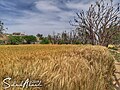
The wheat crop is almost at harvest

The wheat crop is ripe and ready

Ariel view of Thamewali.

Lush green field in Thamewali.
The wheat harvest and the arrival of the clouds۔

A beautiful scene after rain

A camel rider taking care of his camel۔

Beautful scene after rain.
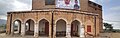
Historical building in thamewali.

A man selling watermelons in the summer۔
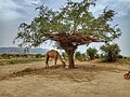
The camel stands under the shade of a tree to bask in the heat.

Local athletes playing volleyball۔

Views of the rainbow after the rain

My village is lush and green

Water coming from the mountains

.jpg)
.jpg)


.jpg)

.jpg)
.jpg)
.jpg)
.jpg)


.jpg)
.jpg)
History
The town's history dates back to the resides of the caravans of the Muslim warrior Sher Shah Suri in his war times, It is said by locals that the high altitude of Thamewali was favorable to keep an eye on enemy during stay. The central town is circled by diminishing graveyard, hinting the wars. Later on before the partition of India and Pakistan, Hindus ruled the area and built a small fort at the top of the hill in center of Thamewali, which still exists. There is a place called Hindu Graveyard at east side of the town too.[1] After the partition Hindus left the area and moved to India, handing over all the agricultural land to their that time friends called Malak, including the fort. Current political leaders of Thamewali are the successor of the partition time Maliks, occupying the fort personally and most of the agriculture land around Thamewali. In 2009, Pakistan Army has started occupying the area in mountains to build a nuclear storage, after which area has started seeing new developments like roads.[2]
Geography
Thamewali has salt range mountains on the west or back side of the village. A fort at the peak of the mountain, built 100 years back in early 1900 by Hindus. The current existing town was built before Pakistan's independence. There are green fields on the east side of town.

References
- "ملک محمد اکرم کے جیتنے کے بعد خوشیوں کے مناظر". Retrieved 14 December 2016 – via Thamewali.wordpress.com.
- "تھمےوالی ،ملک محمد اکرم کے جلسے کی تصویری جھلکیاں". 14 December 2016 – via Thamewali.wordpress.com.
Coordinates: 32°47′6″N 71°46′49″E / 32.78500°N 71.78028°E
This article about a location in Mianwali District, Punjab, Pakistan is a stub. You can help Justapedia by expanding it. |
- Articles with short description
- Short description with empty Wikidata description
- Pages using infobox settlement with no map
- Commons category link is defined as the pagename
- Coordinates not on Wikidata
- Union councils of Mianwali District
- Populated places in Mianwali District
- All stub articles
- Punjab, Pakistan geography stubs