Tarinkot Airport
Tarinkot Airport Pashto: ترينکوټ هوايي ډګر Dari: میدان هوایی ترینکوت | |||||||||||
|---|---|---|---|---|---|---|---|---|---|---|---|
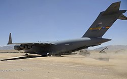
 An American C-17 Globemaster III off-loading equipment before the airport's runway was concreted (June 20, 2009) | |||||||||||
| Summary | |||||||||||
| Airport type | Public / Military | ||||||||||
| Owner | |||||||||||
| Operator | |||||||||||
| Serves | Uruzgan Province | ||||||||||
| Location | Tarinkot, Afghanistan | ||||||||||
| Elevation AMSL | 4,429 ft / 1,350 m | ||||||||||
| Coordinates | 32°36′17″N 65°51′56″E / 32.60472°N 65.86556°ECoordinates: 32°36′17″N 65°51′56″E / 32.60472°N 65.86556°E | ||||||||||
| Map | |||||||||||
| Runways | |||||||||||
| |||||||||||
Tarinkot Airport (Pashto: ترينکوټ هوايي ډګر; Dari: میدان هوایی ترینکوت; IATA: TII, ICAO: OATN) is located about 4 miles (6.4 km) of driving distance south from the center of Tarinkot in Afghanistan, next to the Tarinkot-Kandahar Highway. It is a domestic airport under the country's Ministry of Transport and Civil Aviation (MoTCA), and serves the population of Uruzgan Province.[1] Security in and around the airport is provided by the Afghan National Security Forces.
Situated at an elevation of 4,429 feet (1,350 m) above sea level, Tarinkot Airport's main runway is designated 12/30 with a concrete surface measuring approximately 7,300 by 138 feet (2,225 m × 42 m).[2] The airport has a single story passenger terminal and a separate 4-story tall control tower. The adjacent Ministry of Defense's air base has several heliports, aircraft parking areas, and various buildings used by the Afghan Armed Forces for regular military and periodic emergency relief purposes.[3]
Other nearby major airports to Tarinkot are Nili Airport in neighboring Daykundi Province to the north, Qalat Airport in Zabul Province to the southeast, Ahmad Shah Baba International Airport in Kandahar to the south, Bost Airport in Lashkar Gah to the southwest, and Farah Airport in Farah to the west.
History[edit]
Tarinkot Airport was expanded in the last two decades, mainly by NATO's International Security Assistance Force (ISAF). The current Afghan military base, which is next to the civilian section of the airport, was recognized by ISAF as Multi National Base Tarin Kot.[8]
Airlines and destinations[edit]
On 29 June 2009, Kam Air started flying between Kabul and Tarinkot three times a week. The service was financially supported by the Dutch government as a way to contribute to the development of Afghanistan. The flights were conducted with a Boeing 737 before suspended.
| Airlines | Destinations |
|---|---|
| Kam Air | Kabul[9] |
See also[edit]
References[edit]
- ^ a b "Afghan Civilian and Military Airports Resume Activities". TOLOnews. January 29, 2022. Retrieved 2022-08-06.
- ^ a b "Airport / Airfields Apron & Taxiway Construction". Ceytun Construction & Trade Inc. 2018. Retrieved 2022-08-06.
- ^ a b "Tarinkot Airport". Google Earth. Retrieved 2022-08-06.
- ^ "Airport Records". Dr. Günther Eichhorn. Retrieved 2022-08-06.
- ^ "Tereen/Tarin Kowt (OATN)". [Afghanistan Ministry of Transport and Civil Aviation. Retrieved 1 January 2013.
- ^ Airport information for Tereen, Afghanistan (OATN / TII) at Great Circle Mapper.
- ^ AIP Afghanistan - Important Information Archived 2016-06-17 at the Wayback Machine
- ^ "Tarinkot Airport".
{{cite web}}: CS1 maint: url-status (link) - ^ Kam Air Flight Schedule, May 2014, "Kam Air: Trustable Wings : Flight Schedule". Archived from the original on 2014-07-02. Retrieved 2014-05-25.
External links[edit]
![]() Media related to Tarinkot Airport at Wikimedia Commons
Media related to Tarinkot Airport at Wikimedia Commons
- "Tarinkot Airport" (3D visual). Google Earth.
- "Airport Records". Dr. Günther Eichhorn.
- Aeronautical chart and airport information for OATN at SkyVector
- Accident history for TII at Aviation Safety Network
- Webarchive template wayback links
- CS1 maint: url-status
- Articles with short description
- Short description with empty Wikidata description
- Articles containing Pashto-language text
- Articles containing Dari-language text
- Coordinates not on Wikidata
- Commons category link is defined as the pagename
- AC with 0 elements
- Airports in Afghanistan
- Urozgan Province

