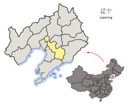
Tai'an County
Jump to navigation
Jump to search
Tai'an
台安县 | |
|---|---|
 Tai'an in Anshan | |
 Anshan in Liaoning | |
| Coordinates: 41°24′47″N 122°26′10″E / 41.413°N 122.436°ECoordinates: 41°24′47″N 122°26′10″E / 41.413°N 122.436°E | |
| Country | People's Republic of China |
| Province | Liaoning |
| Prefecture-level city | Anshan |
| County seat | Tai'an Town (台安镇) |
| Area | |
| • Total | 1,393 km2 (538 sq mi) |
| Elevation | 7 m (24 ft) |
| Population | |
| • Total | 370,000 |
| • Density | 270/km2 (690/sq mi) |
| Time zone | UTC+8 (China Standard) |
| Postal code | 114100 |
Tai'an (Chinese: 台安; pinyin: Tái'ān) is a county in the central part of Liaoning province, People's Republic of China. It is located in the northwest corner of the prefecture-level city of Anshan, and has a population of 370,000[when?] residing in an area of 1,393 km2 (538 sq mi).
Administrative divisions
There are 11 towns under the county's administration.[1]
- Tai'an (台安镇)
- Gaolifang (高力房镇)
- Huangshatuo (黄沙坨镇)
- Xinkaihe (新开河镇)
- Sanglin (桑林镇)
- Jiucaitai (韭菜台镇)
- Xintai (新台镇)
- Fujia (富家镇)
- Huandong (桓洞镇)
- Xifo (西佛镇)
- Daniu (达牛镇)
Climate
| Climate data for Tai'an (1981−2010) | |||||||||||||
|---|---|---|---|---|---|---|---|---|---|---|---|---|---|
| Month | Jan | Feb | Mar | Apr | May | Jun | Jul | Aug | Sep | Oct | Nov | Dec | Year |
| Record high °C (°F) | 7.4 (45.3) |
15.8 (60.4) |
19.3 (66.7) |
28.1 (82.6) |
32.3 (90.1) |
36.0 (96.8) |
35.5 (95.9) |
34.2 (93.6) |
32.2 (90.0) |
28.2 (82.8) |
20.3 (68.5) |
11.6 (52.9) |
36.0 (96.8) |
| Average high °C (°F) | −3.9 (25.0) |
0.4 (32.7) |
7.3 (45.1) |
16.5 (61.7) |
23.1 (73.6) |
26.9 (80.4) |
28.6 (83.5) |
28.4 (83.1) |
24.3 (75.7) |
16.6 (61.9) |
6.1 (43.0) |
−1.4 (29.5) |
14.4 (57.9) |
| Daily mean °C (°F) | −9.7 (14.5) |
−5.4 (22.3) |
1.7 (35.1) |
10.5 (50.9) |
17.4 (63.3) |
22.0 (71.6) |
24.5 (76.1) |
23.8 (74.8) |
18.4 (65.1) |
10.7 (51.3) |
0.8 (33.4) |
−6.7 (19.9) |
9.0 (48.2) |
| Average low °C (°F) | −14.5 (5.9) |
−10.4 (13.3) |
−3.3 (26.1) |
4.9 (40.8) |
12.0 (53.6) |
17.4 (63.3) |
20.8 (69.4) |
19.9 (67.8) |
13.3 (55.9) |
5.6 (42.1) |
−3.6 (25.5) |
−11.2 (11.8) |
4.2 (39.6) |
| Record low °C (°F) | −30.1 (−22.2) |
−25.6 (−14.1) |
−16.2 (2.8) |
−8.5 (16.7) |
0.2 (32.4) |
8.4 (47.1) |
14.3 (57.7) |
7.1 (44.8) |
1.5 (34.7) |
−6.1 (21.0) |
−21.2 (−6.2) |
−27.4 (−17.3) |
−30.1 (−22.2) |
| Average precipitation mm (inches) | 4.4 (0.17) |
4.1 (0.16) |
12.8 (0.50) |
34.4 (1.35) |
47.1 (1.85) |
70.4 (2.77) |
158.7 (6.25) |
157.1 (6.19) |
70.8 (2.79) |
38.1 (1.50) |
14.9 (0.59) |
5.6 (0.22) |
618.4 (24.34) |
| Average relative humidity (%) | 56 | 52 | 51 | 54 | 58 | 70 | 82 | 81 | 72 | 65 | 61 | 59 | 63 |
| Source: China Meteorological Data Service Center[2] | |||||||||||||
References
- ^ 2011年统计用区划代码和城乡划分代码:台安县 (in Chinese). National Bureau of Statistics of the People's Republic of China. Archived from the original on November 29, 2012. Retrieved 2012-07-17.
- ^ 中国地面气候标准值月值(1981-2010) (in Simplified Chinese). China Meteorological Data Service Center. Retrieved 24 September 2022.
Categories:
- CS1 uses Chinese-language script (zh)
- CS1 Chinese-language sources (zh)
- CS1 Simplified Chinese-language sources (zh-hans)
- Articles with short description
- Short description with empty Wikidata description
- Articles containing Chinese-language text
- Coordinates not on Wikidata
- All articles with unsourced statements
- Articles with unsourced statements from September 2018
- All articles with vague or ambiguous time
- Vague or ambiguous time from July 2012
- AC with 0 elements
- County-level divisions of Liaoning
- Anshan
- All stub articles
- Liaoning geography stubs