Tahtlum Peak
Jump to navigation
Jump to search
| Tahtlum Peak | |
|---|---|
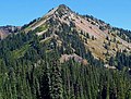
 Tahtlum Peak seen from Highway 410 | |
| Highest point | |
| Elevation | 6,567 ft (2,002 m)[1] |
| Prominence | 1,135 ft (346 m)[1] |
| Isolation | 1.6 mi (2.6 km)[2] |
| Coordinates | 46°51′52″N 121°28′39″W / 46.864374°N 121.477472°WCoordinates: 46°51′52″N 121°28′39″W / 46.864374°N 121.477472°W |
| Geography | |
 Tahtlum Peak Location of Tahtlum Peak in Washington  Tahtlum Peak Tahtlum Peak (the United States) | |
| Location | Yakima County, Washington, U.S. |
| Parent range | Cascades |
| Topo map | USGS Cougar Lake |
| Climbing | |
| Easiest route | Hiking class 2 |
Tahtlum Peak is a 6,567-foot-elevation (2,002 meter) mountain summit located east-southeast of Chinook Pass in the William O. Douglas Wilderness. It's situated north of Dewey Lake in Yakima County of Washington state. Tahtlum Peak is part of the Cascade Range and its nearest higher neighbor is Dewey Peak, 1.61 mi (2.59 km) to the south.[1] The name tahtlum derives from Chinook Jargon which means ten.[3] Precipitation runoff from Tahtlum Peak drains into tributaries of the Yakima River.
Gallery

West aspect

Tahtlum Peak reflected in Dewey Lake


Approaching Tahtlum Peak from west


References
- ^ a b c "Tahtlum Peak, Washington". Peakbagger.com.
- ^ ""Tahtlum Peak" - 6,567' WA". listsofjohn.com. Retrieved 2020-06-13.
- ^ "The Number System of Chinook Wawa".
External links
- National Forest Service web site: William O Douglas Wilderness