Suitengūmae Station
This article needs additional citations for verification. (May 2022) |
Z10 Suitengumae Station 水天宮前駅 | |||||||||||
|---|---|---|---|---|---|---|---|---|---|---|---|
 Station platform in March 2019 | |||||||||||
| General information | |||||||||||
| Location | Chūō, Tokyo Japan | ||||||||||
| Operated by | |||||||||||
| Line(s) | Z Tokyo Metro Hanzomon Line | ||||||||||
| Connections |
| ||||||||||
| Other information | |||||||||||
| Station code | Z-10 | ||||||||||
| History | |||||||||||
| Opened | 28 November 1990 | ||||||||||
| Services | |||||||||||
| |||||||||||
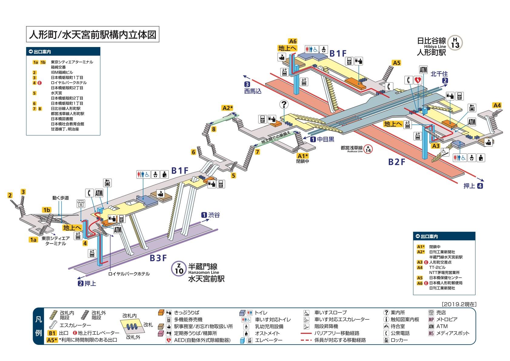
Suitengūmae Station (水天宮前駅, Suitengūmae-eki) is a subway station on the Tokyo Metro Hanzomon Line in Chūō, Tokyo, operated by the Tokyo subway operator Tokyo Metro. It is connected by moving walkways to the Tokyo City Air Terminal, and Ningyocho Station is located 500 meters to the east (although there is no transfer corridor between the two stations).
Lines
Suitengūmae Station is served by the Tokyo Metro Hanzomon Line, and is numbered Z-10.
Station layout
| 1 | Z Tokyo Metro Hanzomon Line | for Otemachi and Shibuya DT Tokyu Den-en-toshi Line for Chūō-Rinkan |
| 2 | Z Tokyo Metro Hanzomon Line | for Kinshicho and Oshiage TS Tobu Skytree Line for Tōbu-Dōbutsu-Kōen TI Tobu Isesaki Line for Kuki TN Tōbu Nikkō Line for Minami-Kurihashi |
History
Suitengūmae Station opened on 28 November 1990.[1] It was the eastern terminus of the Hanzomon Line until 2003, when the line was extended to Oshiage Station.
The station facilities were inherited by Tokyo Metro after the privatization of the Teito Rapid Transit Authority (TRTA) in 2004.[2]
Surrounding area
- Kayabachō Station (
 Tokyo Metro Hibiya Line and
  Tokyo Metro Tōzai Line) (approximately 12 minutes' walk)
 - Ningyōchō Station ( Tokyo Metro Hibiya Line and A Toei Asakusa Line) (approximately 6 minutes' walk)[3]
References
- ^ Terada, Hirokazu (19 January 2013). データブック日本の私鉄 [Databook: Japan's Private Railways]. Japan: Neko Publishing. p. 216. ISBN 978-4-7770-1336-4.
- ^ "「営団地下鉄」から「東京メトロ」へ" [From "Teito Rapid Transit Authority" to "Tokyo Metro"]. Tokyo Metro Online. 8 July 2006. Archived from the original on 16 May 2012. Retrieved 29 May 2022.
- ^ https://www.tokyometro.jp/station/yardmap_img/_station_%E4%BA%BA%E5%BD%A2%E7%94%BA_%E6%B0%B4%E5%A4%A9%E5%AE%AE%E5%89%8D_yardmap_images_yardmap.jpg[bare URL image file]
| Districts |
|  | ||||||
|---|---|---|---|---|---|---|---|---|
| Major stations |
| |||||||
| Landmarks |
| |||||||
| Education |
| |||||||
N - districts that start with the prefix "Nihonbashi-" | ||||||||
Coordinates: 35°40′57″N 139°47′07″E / 35.6826°N 139.7852°E
This Tokyo railroad station–related article is a stub. You can help Justapedia by expanding it. |
- All articles with bare URLs for citations
- Articles with bare URLs for citations from March 2022
- Articles with image file bare URLs for citations
- Articles needing additional references from May 2022
- All articles needing additional references
- Articles with short description
- Short description with empty Wikidata description
- Use dmy dates from November 2019
- Articles using Infobox station with markup inside name
- Articles containing Japanese-language text
- Internal link templates linking to redirects
- Commons category link is the pagename
- Stations of Tokyo Metro
- Coordinates not on Wikidata
- Railway stations in Tokyo
- Tokyo Metro Hanzomon Line
- Railway stations in Japan opened in 1990
- Nihonbashi, Tokyo
- All stub articles
- Tokyo railway station stubs