Stettfeld
Jump to navigation
Jump to search
Stettfeld | |
|---|---|
 Town hall (left), rectory (right) with the Church of the Assumption of the Virgin Mary in the back | |
 Coat of arms | |
Location of Stettfeld within Haßberge district 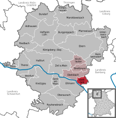  | |
 Stettfeld  Stettfeld | |
| Coordinates: 49°58′N 10°43′E / 49.967°N 10.717°ECoordinates: 49°58′N 10°43′E / 49.967°N 10.717°E | |
| Country | Germany |
| State | Bavaria |
| Admin. region | Unterfranken |
| District | Haßberge |
| Municipal assoc. | Ebelsbach |
| Government | |
| • Mayor (2020–26) | Alfons Hartlieb[1] (CSU) |
| Area | |
| • Total | 11.16 km2 (4.31 sq mi) |
| Elevation | 240 m (790 ft) |
| Population (2020-12-31)[2] | |
| • Total | 1,143 |
| • Density | 100/km2 (270/sq mi) |
| Time zone | UTC+01:00 (CET) |
| • Summer (DST) | UTC+02:00 (CEST) |
| Postal codes | 96188 |
| Dialling codes | 09522 |
| Vehicle registration | HAS |
| Website | vg-ebelsbach.de |
Stettfeld is a municipality in the district of Haßberge in Bavaria in Germany.
References
- ^ Liste der ersten Bürgermeister/Oberbürgermeister in kreisangehörigen Gemeinden, Bayerisches Landesamt für Statistik, 15 July 2021.
- ^ "Tabellenblatt "Daten 2", Statistischer Bericht A1200C 202041 Einwohnerzahlen der Gemeinden, Kreise und Regierungsbezirke". Bayerisches Landesamt für Statistik (in German). June 2021.
Towns and municipalities in Haßberge (district) | ||
|---|---|---|
This Haßberge location article is a stub. You can help Justapedia by expanding it. |