Stanmore, New South Wales
| Stanmore Sydney, New South Wales | |||||||||||||||
|---|---|---|---|---|---|---|---|---|---|---|---|---|---|---|---|
 Aerial view of the suburb | |||||||||||||||
<mapframe>: The JSON content is not valid GeoJSON+simplestyle. The list below shows all attempts to interpret it according to the JSON Schema. Not all are errors.
| |||||||||||||||
| Postcode(s) | 2048 | ||||||||||||||
| Elevation | 38 m (125 ft) | ||||||||||||||
| Area | 2.0 km2 (0.8 sq mi) | ||||||||||||||
| Location | 6 km (4 mi) south west of Sydney CBD | ||||||||||||||
| LGA(s) | Inner West Council | ||||||||||||||
| State electorate(s) | Newtown | ||||||||||||||
| Federal division(s) | Grayndler | ||||||||||||||
| |||||||||||||||
.jpg)
- /2/ids: Does not match the regex pattern ^Q[1-9]\d{0,19}(\s*,\s*Q[1-9]\d{0,19})*$
- /2/ids: String value found, but an array is required
- /2/ids: Failed to match exactly one schema
- /2/title: The property title is required
- /2/service: Does not have a value in the enumeration ["page"]
- /2: Failed to match exactly one schema
- /2/geometries: The property geometries is required
- /2/type: Does not have a value in the enumeration ["GeometryCollection"]
- /2/type: Does not have a value in the enumeration ["MultiPolygon"]
- /2/type: Does not have a value in the enumeration ["Point"]
- /2/type: Does not have a value in the enumeration ["MultiPoint"]
- /2/type: Does not have a value in the enumeration ["LineString"]
- /2/type: Does not have a value in the enumeration ["MultiLineString"]
- /2/type: Does not have a value in the enumeration ["Polygon"]
- /2/coordinates: The property coordinates is required
- /2/geometry: The property geometry is required
- /2/type: Does not have a value in the enumeration ["Feature"]
- /2/features: The property features is required
- /2/type: Does not have a value in the enumeration ["FeatureCollection"]
Stanmore is a suburb in the Inner West of Sydney, in New South Wales, Australia 6 kilometres south west of the Sydney central business district. It is part of the local government area of the Inner West Council. It is known for its long strip of shops running along Parramatta Road (Great Western Highway).
History
Prior to settlement by the British the site was populated by coastal aborigines known as the Gadigal clan of the Eora people. Land in the present Stanmore area was first allocated to colonial officers by Governor Arthur Phillip between 1793 and 1810.
Stanmore was named by a saddler, John Jones, who settled on the land in 1835 where Newington College now stands and called it the Stanmore Estate. Jones named it after his birthplace of Stanmore, now a north-west suburb of London. Thomas Rowley owned Kingston Farm which occupied the eastern half of Stanmore and much of Newtown, and a portion of George Johnston's Annandale Farm estate covered the area south of Parramatta Road containing Annandale House built in 1799 on the hill between Macaulay and Albany Roads. Johnston marched from here with his troops to Castle Hill on 5 March 1804 to quell the convict revolt. He also rode from here on 26 January 1808 to arrest Governor William Bligh during the Rum Rebellion.[1] Johnston planted the first Norfolk pines on the Australian mainland along the line of Percival Road, leading to Parramatta Road.
Stanmore Road was constructed in 1835 and early development occurred in this area. In 1855, the railway divided Stanmore into areas known as North and West Kingston north of the railway, and South Kingston south of the railway. The Kingston Farm had been sold to James Holt in 1835, and North Kingston was subdivided in 1854. South Kingston (between the railway and Stanmore Road) was slowly subdivided from 1857 with isolated large houses built between 1860 and 1870. It was not until the late 19th century that the name Stanmore came into more regular use, replacing Kingston. Municipal boundaries established in 1861 and 1871 placed most of Stanmore into the Municipality of Petersham, with the area south of Stanmore Rd placed into the Municipality of Marrickville. In 1878, Stanmore railway station was established and the streets west of Percival Road were laid out. More intensive development subsequently occurred in this area and the name Stanmore slowly moved northwards from Stanmore to Parramatta Roads. Stanmore became a desirable location, booming in the 1880s and 1890s with the opening of Newington College and the Percival Road shopping area. The naming of streets after English colonies between Derby and Stafford streets reflected the English values of the time. The final subdivision of Johnston's South Annandale estate took place in 1905, and building was not completed until 1916-1918. Annandale House was demolished in 1905, and Weekley Park was established on land donated by the Johnston family.[2]
A small amount of light industry was established in the early 1920s in the area close to Parramatta Road, including H. Small and Co., a chocolate maker opening in 1928, and Starkeys Cordials. Both establishments have since closed and their premises have been converted into offices and apartments.
Heritage listings
Stanmore has several heritage-listed sites, including:
- 37 Cavendish Street: New South Wales Aboriginal Education Consultative Group Office[3]
- 125 Corunna Road: Corunna Road Sewer Vent and Cottage[4]
- Great Southern and Western railway: Stanmore railway station[5]
Population
In the 2021 census, Stanmore had a population of 7,619 people, 68.3% of whom were born in Australia. The next most common countries of birth were England 4.6%, New Zealand 2.1%, Portugal 1.4%, China (excludes SARs and Taiwan) 1.2% and Greece 1.2%. The most common responses for religion in Stanmore (NSW) were No Religion, 54.0%, Catholic 18.9%, Not stated 5.2%, Anglican 6.0% and Eastern Orthodox 4.6%. 76% of households only spoke English at home. 25.4% of households were non-English speaking. The top responses for languages used at home (other than English) were Greek 2.5% Spanish 1.9% Italian 1.8% Portuguese 1.6% and Mandarin 1.5%.[6]
In the 2016 census, there were 7,938 people living in Stanmore,[7] while in the 2011 census the number was 7,702.[8]
Commercial area and transport
Stanmore railway station is on the Inner West & Leppington Line of the Sydney Trains network. Stanmore has a small shopping centre beside Stanmore railway station. Commercial developments also run along the length of Parramatta Road.
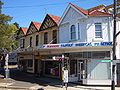
Trafalgar Street shops
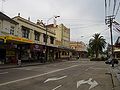
Percival Road shops


Schools


Stanmore is home to Newington College, an independent GPS boys school, the state primary Stanmore Public School and Saint Michael's Catholic Primary School Stanmore.
Both Newington and Stanmore Public are of heritage significance and the main buildings of distinguished designs. Of Newington's design by Thomas Rowe the architectural historian Morton Herman said:[9]
The 1881 building is an almost perfect example of scholastic Gothic Revival architecture.
Of Stanmore Public School's design by Blackmann and Parkes Herman said:
... the whole building is a very pleasant essay in correct and simple classicism, with the triple stairs giving unexpected dignity.
Sport and recreation
Apart from the private facilities at Newington College, sporting and recreation facilities in Stanmore are limited to a handful of small parks and playgrounds including Weekley Park, Crammond Park and Montague Gardens. Stanmore does lend its name, however, to the Stanmore Hawks soccer club which plays in the NSW State League Division One, the third tier of senior soccer in Sydney.
Churches
Churches in Stanmore include St Michael The Archangel Catholic Church, and Stanmore Baptist Church.
Notable people

Notable people from or who have lived in Stanmore include:
- Sid Barnes (1916–1973), Test cricketer
- Sir Garfield Barwick (1903–1997), 7th Chief Justice of Australia, raised in Stanmore
- Vivian Gordon Bowden (1884–1942), businessman and diplomat, born in Stanmore
- Euphemia Bridges Bowes (1816–1900), suffragette and social activist, lived in Stanmore
- Nicholas Brown (b. 1980), actor, singer-songwriter, screenwriter
- Matt Doran (b. 1976), actor
- Thelma Forshaw (1923–1995), writer, journalist, attended St Michael's Catholic School
- Tom Frame (b.1962), Anglican bishop, historian, academic, born in Stanmore
- Richard Gill AO (1941−2018), Conductor and musical education advocate lived in Stanmore
- John Gowing (1835–1908), Gowings founder, lived in Stanmore
- William Parker Henson (1905–1999), Chairman Sydney County Council, born in Stanmore[10]
- Harold Holt (1908–1967), 17th Prime Minister of Australia, born in Stanmore
- Amy Mathews (b.1979), Home and Away actress
- Leigh Sales (b. 1973), ABC Journalist[11]
- Frank Stanmore (1929−2005), rugby league player, lived in Stanmore
References
- ^ The Book of Sydney Suburbs, Compiled by Frances Pollen, Angus & Robertson Publishers, 1990, Published in Australia ISBN 0-207-14495-8, page 246
- ^ Cashman, R and Meader, C. Marrickville- Rural outpost to inner City. Hale & Iremonger Pty Ltd, 1997. ISBN 0-86806-639-7.
- ^ "NSW Aboriginal Education Consultative Group Office and Records". New South Wales State Heritage Register. Office of Environment & Heritage. H01964. Retrieved 18 February 2020.
- ^ "Sewer Vent and Cottage". New South Wales State Heritage Register. Office of Environment & Heritage. H01635. Retrieved 18 May 2018.
- ^ "Stanmore Railway Station Group". New South Wales State Heritage Register. Office of Environment & Heritage. H01251. Retrieved 18 May 2018.
- ^ "2021 Stanmore (NSW), Census All persons QuickStats". Australian Bureau of Statistics. Retrieved 14 August 2022.
- ^ Australian Bureau of Statistics (27 June 2017). "Stanmore (State Suburb)". 2016 Census QuickStats. Retrieved 14 March 2018.
- ^ "2011 Stanmore (NSW), Census All persons QuickStats". Australian Bureau of Statistics. Retrieved 14 August 2022.
- ^ The Architecture of Victorian Sydney (Syd, 1956)pp 76
- ^ Sydney's Alderman – William Parker Henson. Retrieved 28 June 2013.
- ^ https://www.domain.com.au/news/abc-presenter-leigh-sales-lists-her-glebe-home-for-3-million-20171013-gyz9mc/
External links
- Stanmore Baptist Church Website
- Olympia Milk Bar, Parramatta Road, Stanmore
- Marrickville Heritage Society
- Official Newtown, Stanmore Government Website
- Chrys Meader - Marrickville Council (2008). "Stanmore". Dictionary of Sydney. Retrieved 29 September 2015. [CC-By-SA]
Coordinates: 33°53′39″S 151°09′52″E / 33.8942°S 151.1644°E
- Australian Statistical Geography Standard 2016 ID not in Wikidata
- Articles needing cleanup from August 2022
- Articles with bare URLs for citations from August 2022
- All articles with bare URLs for citations
- Use Australian English from August 2019
- All Wikipedia articles written in Australian English
- Use dmy dates from March 2022
- Articles with short description
- Short description with empty Wikidata description
- Suburbs of Sydney
- Commons category link is the pagename
- Coordinates not on Wikidata
- AC with 0 elements
- Stanmore, New South Wales
- Inner West
- Pages with broken maps