Silala River
Jump to navigation
Jump to search
| Silala | |
|---|---|
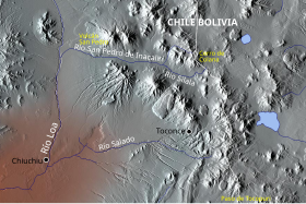
 Loa and its tributaries San Pedro, Silala and Salado Rivers | |
| Location | |
| Countries | |
| Department (BO) | Potosí |
| Region (CL) | Antofagasta |
| Physical characteristics | |
| Source | |
| • elevation | c. 4400 m asl[1] |
| Mouth | |
• location | Inacaliri River[1] |
| Length | 8.5 km[1] |
| Discharge | |
| • location | Bolivia–Chile border |
| • average | 160 L/s[1] |
The Silala or Siloli[1] is an aquifer and river arising from springs in Bolivia, and flowing into Chile.
The division of the flow from this water body has been a matter of controversy between the two nations, Chile claiming that the present route makes it an international river, while Bolivia denies there is a river and asserts that the Silala ‘springs’ would not flow to Chile if not for the construction of canals over a hundred years ago.[2][3][4][5]
See also
References
- Notes
- ^ a b c d e Application, June 6, 2016
- ^ tierraamerica.net Archived 2011-07-27 at the Wayback Machine
- ^ Newton, Joshua, "The Disputed Silala River: A Catalyst for Cooperation? " (2007). Water Resources Research Center Conferences. Paper 28. link Accessed 8 April 2011
- ^ Gabriel Eckstein and Brendan M. Mulligan Water Resources Development, Vol. 27, No. 3, pp. 595-606, September 2011. Posted on SSRN September 1, 2011 link Accessed 8 April 2011
- ^ Gabriel Eckstein. The Silala Basin: One of the Most Hydropolitically Vulnerable Basins in the World. International Water Law Project Blog link Accessed 8 April 2011
- Sources
- EVALUACION DE LOS RECURSOS HIDRICOS SUPERFICIALES EN LA CUENCA DEL RIO BIO BIO[permanent dead link] (PDF)
Coordinates: 22°00′32″S 68°00′12″W / 22.0089°S 68.0033°W
Categories:
- Webarchive template wayback links
- Articles with short description
- Short description with empty Wikidata description
- All articles with dead external links
- Articles with dead external links from May 2018
- Articles with permanently dead external links
- AC with 0 elements
- Coordinates not on Wikidata
- Rivers of Chile
- Rivers of Bolivia
- Rivers of Antofagasta Region
- Rivers of Potosí Department
- International rivers of South America
- All stub articles
- Potosí Department geography stubs
- Bolivia river stubs
- Antofagasta Region geography stubs
- Chile river stubs