Shire of Lake Grace
Jump to navigation
Jump to search
| Shire of Lake Grace Western Australia | |||||||||||||||
|---|---|---|---|---|---|---|---|---|---|---|---|---|---|---|---|
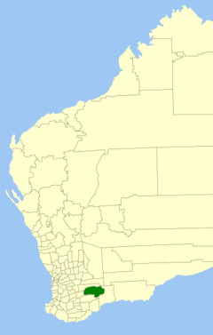
 Location in Western Australia | |||||||||||||||
| Established | 1922 | ||||||||||||||
| Area | 10,379.2 km2 (4,007.4 sq mi) | ||||||||||||||
| Shire President | Leonard William Armstrong | ||||||||||||||
| Council seat | Lake Grace | ||||||||||||||
| Region | Wheatbelt | ||||||||||||||
| State electorate(s) | Roe | ||||||||||||||
| Federal division(s) | O'Connor | ||||||||||||||
| File:Lake grace logo.png | |||||||||||||||
| Website | Shire of Lake Grace | ||||||||||||||
| |||||||||||||||
The Shire of Lake Grace is a local government area in the eastern Wheatbelt region of Western Australia, about 350 kilometres (217 mi) ESE of the state capital, Perth. The Shire has a land area of 10,379 square kilometres (4,007 sq mi) and its seat of government is the town of Lake Grace.
History
The Lake Grace Road District was gazetted on 22 December 1922. On 1 July 1961, it became a Shire under the Local Government Act 1960, which reformed all remaining road districts into shires.[1]
Towns and localities
Heritage-listed places
As of 2021, 231 places are heritage-listed in the Shire of Lake Grace,[2] of which three are on the State Register of Heritage Places.[3]
References
- ^ "Municipality Boundary Amendments Register" (PDF). Western Australian Electoral Distribution Commission. Retrieved 11 January 2020.
- ^ "Shire of Lake Grace Heritage Places". inherit.stateheritage.wa.gov.au. Heritage Council of Western Australia. Retrieved 27 March 2021.
- ^ "Shire of Lake Grace State Register of Heritage Places". inherit.stateheritage.wa.gov.au. Heritage Council of Western Australia. Retrieved 27 March 2021.
External links
- No URL found. Please specify a URL here or add one to Wikidata.
Categories:
- Articles with short description
- Short description with empty Wikidata description
- Use Australian English from August 2019
- All Wikipedia articles written in Australian English
- Use dmy dates from August 2019
- Populated places established in 1922
- 1922 establishments in Australia
- Official website missing URL
- Coordinates not on Wikidata
- Shire of Lake Grace
- Local government areas of the Wheatbelt region of Western Australia