Schulzendorf
Jump to navigation
Jump to search
Schulzendorf | |
|---|---|
 Coat of arms | |
Location of Schulzendorf within Dahme-Spreewald district   | |
 Schulzendorf  Schulzendorf | |
| Coordinates: 52°22′00″N 13°34′59″E / 52.36667°N 13.58306°ECoordinates: 52°22′00″N 13°34′59″E / 52.36667°N 13.58306°E | |
| Country | Germany |
| State | Brandenburg |
| District | Dahme-Spreewald |
| Subdivisions | 4 Ortsteile |
| Government | |
| • Mayor (2017–25) | Markus Mücke[1] (SPD) |
| Area | |
| • Total | 9.08 km2 (3.51 sq mi) |
| Elevation | 37 m (121 ft) |
| Population (2021-12-31)[2] | |
| • Total | 9,327 |
| • Density | 1,000/km2 (2,700/sq mi) |
| Time zone | UTC+01:00 (CET) |
| • Summer (DST) | UTC+02:00 (CEST) |
| Postal codes | 15732 |
| Dialling codes | 033762 |
| Vehicle registration | LDS |
| Website | www.schulzendorf.de |
![]() Schulzendorf (help·info) is a municipality in the district of Dahme-Spreewald in Brandenburg in Germany.
Schulzendorf (help·info) is a municipality in the district of Dahme-Spreewald in Brandenburg in Germany.
Demography[edit]
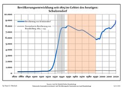
Development of Population since 1875 within the Current Boundaries (Blue Line: Population; Dotted Line: Comparison to Population Development of Brandenburg state; Grey Background: Time of Nazi rule; Red Background: Time of Communist rule)
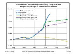
Recent Population Development and Projections (Population Development before Census 2011 (blue line); Recent Population Development according to the Census in Germany in 2011 (blue bordered line); Official projections for 2005-2030 (yellow line); for 2020-2030 (green line); for 2017-2030 (scarlet line)
|
|
|
References[edit]
- ^ Landkreis Dahme-Spreewald Wahl der Bürgermeisterin / des Bürgermeisters, accessed 30 June 2021.
- ^ "Bevölkerungsentwicklung und Flächen der kreisfreien Städte, Landkreise und Gemeinden im Land Brandenburg 2021" (PDF). Amt für Statistik Berlin-Brandenburg (in German). June 2022.
- ^ Detailed data sources are to be found in the Wikimedia Commons.Population Projection Brandenburg at Wikimedia Commons
This Brandenburg location article is a stub. You can help Justapedia by expanding it. |
Categories:
- CS1 German-language sources (de)
- Articles with short description
- Short description with empty Wikidata description
- Coordinates not on Wikidata
- Municipalities in Brandenburg
- Articles with hAudio microformats
- AC with 0 elements
- Localities in Dahme-Spreewald
- Teltow (region)
- All stub articles
- Brandenburg geography stubs