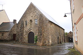
Saint-Aubin-des-Châteaux
Jump to navigation
Jump to search
Saint-Aubin-des-Châteaux | |
|---|---|
Commune | |
 Chapel of the Templars | |
| Coordinates: 47°43′15″N 1°29′06″W / 47.7208°N 1.485°WCoordinates: 47°43′15″N 1°29′06″W / 47.7208°N 1.485°W | |
| Country | France |
| Region | Pays de la Loire |
| Department | Loire-Atlantique |
| Arrondissement | Châteaubriant-Ancenis |
| Canton | Châteaubriant |
| Intercommunality | Châteaubriant-Derval |
| Government | |
| • Mayor (2020–2026) | Daniel Rabu |
| Area 1 | 47.56 km2 (18.36 sq mi) |
| Time zone | UTC+01:00 (CET) |
| • Summer (DST) | UTC+02:00 (CEST) |
| INSEE/Postal code | 44153 /44110 |
| Elevation | 32–92 m (105–302 ft) (avg. 65 m or 213 ft) |
| 1 French Land Register data, which excludes lakes, ponds, glaciers > 1 km2 (0.386 sq mi or 247 acres) and river estuaries. | |
Saint-Aubin-des-Châteaux (French pronunciation: [sɛ̃.t‿obɛ̃ de ʃato] (![]() listen); Breton: Sant-Albin-ar-C'hestell) is a commune in the Loire-Atlantique department in western France.[1]
listen); Breton: Sant-Albin-ar-C'hestell) is a commune in the Loire-Atlantique department in western France.[1]
Geography[edit]
The village is located in the northwestern part of the commune on the right bank of the river Chère, which flows southwest through the commune.
Population[edit]
|
|
See also[edit]
References[edit]
Wikimedia Commons has media related to Saint-Aubin-des-Châteaux.
Categories:
- Articles with short description
- Short description with empty Wikidata description
- Coordinates not on Wikidata
- France articles requiring maintenance
- Articles with hAudio microformats
- Articles containing Breton-language text
- Commons category link is the pagename
- AC with 0 elements
- Communes of Loire-Atlantique
- All stub articles
- Loire-Atlantique geography stubs


