Rotomā Caldera
| Rotomā Caldera | |
|---|---|
| Rotoma Caldera | |
 Lake Rotomā fills the Rotomā Caldera | |
| Highest point | |
| Elevation | 316 m (1,037 ft) |
| Coordinates | 38°05′S 176°35′E / 38.083°S 176.583°ECoordinates: 38°05′S 176°35′E / 38.083°S 176.583°E |
| Dimensions | |
| Width | 5 km (3.1 mi) |
| Geography | |
| Country | New Zealand |
| Region | Bay of Plenty |
| Geology | |
| Age of rock | approximately 9,000 years |
| Mountain type | Caldera |
| Volcanic region | Taupō Volcanic Zone |
| Last eruption | 7412 BCE |
| Climbing | |
| Access | State Highway 30 (New Zealand) |
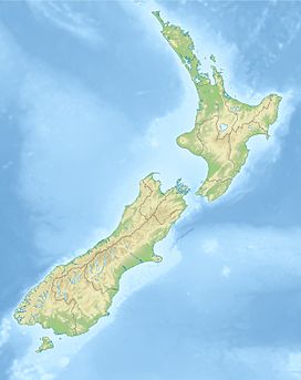
The relatively small Rotomā Caldera (Rotomā volcanic complex, also spelled Rotoma) is in the Taupō Volcanic Zone in the North Island of New Zealand.
Geography
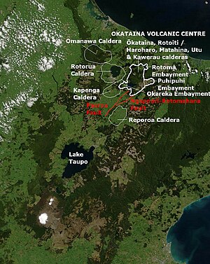
The Rotomā Caldera is located halfway between the city of Rotorua and town of Whakatāne, with its in filling Lake Rotomā being the easternmost in the chain of three volcanic lakes to the northeast of Lake Rotorua. The other two are Lake Rotoiti and Lake Rotoehu.
Geology
It is immediately to the northeast of the area formally called the Haroharo volcanic complex, and now known as the Haroharo Caldera[1] which is now regarded as part of the much larger Ōkataina Caldera ( Ōkataina Volcanic Centre).[2] It is now also usually classified as part of this volcanic structure, but is regarded as the far eastern extension of the Haroharo linear vent zone within the Ōkataina Caldera.[3][4] It is associated with the northern fault boundary zone (Rotoehu Fault, Manawahe Fault, North Rotomā Fault, Braemar Fault, Mangaone Fault) of current rift activity in the Taupō Volcanic Zone. The caldera is likely overlying the former drainage valley that historically Lake Rotorua used before the Rotoiti eruption of the Ōkataina Caldera 47,400 ± 1500 years ago.[5] The Rotomā volcano's most prominent feature Lake Rotomā was formed within the Rotomā caldera when lava flows following a large crater explosion blocked its outlet. The major eruption episodes were about 7412 BCE with about 8 km3 (1.9 cu mi) of material erupted from 3 different magmas from several different vents.[3][4] It is known that the changes in vegetation following the eruption, while significant were short-lived, with pre-eruption forest and mire vegetation recovering to former levels within about 106 years.[6]
References
- ^ "Okataina Volcanic Centre Geology," GNS science. Retrieved 11 June 2022.
- ^ McKinnon, M., "Okataina caldera and its neighbours," Te Ara - Encyclopedia of New Zealand, 1 May 2015. Retrieved 11 June 2022.
- ^ a b Smith, Victoria; Shane, Phil; Nairn, I.A.; Williams, Catherine (1 July 2006). "Geochemistry and magmatic properties of eruption episodes from Haroharo linear vent zone, Okataina Volcanic Centre, New Zealand during the last 10 kyr". Bulletin of Volcanology. 69 (1): 57–88. doi:10.1007/s00445-006-0056-7.
- ^ a b Cole, J. W.; Spinks, K. D. (2009). "Caldera volcanism and rift structure in the Taupo Volcanic Zone, New Zealand". Special Publications. London: Geological Society. 327 (1): 9–29. Bibcode:2009GSLSP.327....9C. doi:10.1144/SP327.2. S2CID 131562598.
- ^ Gilgour, G.N.; Smith, R.T. (2008). "Stratigraphy, dynamics, and eruption impacts of the dual magma Rotorua eruptive episode, Okataina Volcanic Centre, New Zealand" (PDF). New Zealand Journal of Geology & Geophysics. 51: 367–378.
- ^ Giles, Teresa Mary (1999). "Volcanic emissions and distal palaeoenvironmental impacts in New Zealand" (PDF). Retrieved 19 June 2022.


