Pachatusan
| Pachatusan | |
|---|---|
 Cusco with the mountains Pillku Urqu (on the left) and Pachatusan (center) in the background | |
| Highest point | |
| Elevation | 4,842 m (15,886 ft)[1] |
| Coordinates | 13°31′10″S 71°46′50″W / 13.51944°S 71.78056°WCoordinates: 13°31′10″S 71°46′50″W / 13.51944°S 71.78056°W |
| Naming | |
| Language of name | Quechua |
| Geography | |
 Pachatusan Peru | |
| Location | Peru, Cusco Region |
| Parent range | Andes |
Pachatusan (Quechua pacha earth, tusa, a prop to support a wall or building, pachatusa prop of the earth, -n a suffix) is a mountain northeast of the city of Cusco in the Andes of Peru, about 4,842 metres (15,886 ft) high. It is located in the Cusco Region, Calca Province, San Salvador District, in the Cusco Province, in the districts San Jerónimo and Saylla, and in the Quispicanchi Province, Oropesa District. It is situated on the western bank of the Vilcanota River, beside the mountain Huaypun in the south-east.[2] Pachatusan lies above the sanctuary of San Salvador named Señor de Huanca.
By the local people Pachatusan is venerated as an apu.
On February 16, 2009, the cultural archaeological landscape of Pachatusan was declared a National Cultural Heritage by Resolución Directoral Nacional No. 231/INC.[3]
Gallery
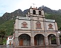
Pachatusan above the sanctuary Señor de Huanca

See also
References
- ^ conservation.org "Forests for Water in the Sacred Mountain "
- ^ escale.minedu.gob.pe - UGEL map of the Calca Province (Cusco Region)
- ^ Resolución Directoral Nacional No. 913/INC
This Cusco Region geography article is a stub. You can help Justapedia by expanding it. |
This article about the history of Peru is a stub. You can help Justapedia by expanding it. |
This South American archaeology article is a stub. You can help Justapedia by expanding it. |
- Articles with short description
- Short description with empty Wikidata description
- Coordinates not on Wikidata
- Pages using infobox mountain with language parameter
- Mountains of Peru
- Mountains of Cusco Region
- Archaeological sites in Peru
- Archaeological sites in Cusco Region
- All stub articles
- Cusco Region geography stubs
- Peruvian history stubs
- South American archaeology stubs