Otar (village)
Jump to navigation
Jump to search
Otar
Отар | |
|---|---|
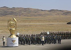
 View of the Otar Military Base in 2017 | |
| Coordinates: 43°32′15″N 75°12′32″E / 43.53750°N 75.20889°ECoordinates: 43°32′15″N 75°12′32″E / 43.53750°N 75.20889°E | |
| Country | Kazakhstan |
| Region | Zhambyl Region |
| District | Korday District |
| Population (2009) | |
| • Total | 4,540 |
| Time zone | UTC+6 (Omsk Time) |
| Postcode | 040306 |
Otar (Kazakh: Отар) is a village in the Zhambyl Region, south-eastern Kazakhstan. It is the administrative center of the Otar rural district (KATO code - 314851100).[1] Population: 4,540 (2009 Census results);[2] 4,355 (1999 Census results).[2][3]
Geography
Otar is located just west of the border with the Almaty Region by the southern end of the Chu-Ili Range. 1.5 kilometers (0.93 mi) to the east of the village lies the Otar Military Base.[4][5]
References
- ^ "База КАТО". Агентство Республики Казахстан по статистике. Archived from the original on 2013-09-27.
- ^ a b "Население Республики Казахстан" (in Russian). Департамент социальной и демографической статистики. Retrieved 8 December 2013.
- ^ "Итоги Национальной переписи населения Республики Казахстан 2009 года" (PDF). Агентство Республики Казахстан по статистике. Archived from the original (PDF) on 2013-02-27.
- ^ "M-43 Topographic Chart (in Russian)". Retrieved 3 October 2022.
- ^ Google Earth.
External links

