Niğde
This article has multiple issues. Please help improve it or discuss these issues on the talk page. (Learn how and when to remove these template messages)
|
Niğde | |
|---|---|
 View from Nigde Castle | |
|
Coat of arms of Niğde Coat of arms | |
 Niğde | |
| Coordinates: 37°58′00″N 34°40′45″E / 37.96667°N 34.67917°ECoordinates: 37°58′00″N 34°40′45″E / 37.96667°N 34.67917°E | |
| Country | Turkey |
| Province | Niğde |
| Government | |
| • Mayor | Emrah Özdemir (AKP) |
| Area | |
| • District | 2,302.99 km2 (889.19 sq mi) |
| Elevation | 1,229 m (4,032 ft) |
| Population (2021) | |
| • Total | 362,071 |
| • Total density | 160/km2 (410/sq mi) |
| Website | www.nigde.bel.tr |
Niğde (Turkish pronunciation: [ni:de]; Ancient Greek: Νίγδη; Hittite: Nahita, Naxita) is a city and the capital of Niğde province in the Central Anatolia region of Turkey at an elevation of 1,299 m. In 2017 the city population was 141,010 people.[2]
The city is small with plenty of green space and gardens around the houses. Its people generally tend to be religious and conservative.
Medieval monuments are scattered about the centre of the town, especially around the market place.
The nearest airport is Nevşehir Kapadokya Airport (NAV) which is 90.6 km (50.6 miles) away.
History


Niğde is located near a number of ancient trade routes, particularly the road from Kayseri (ancient Caesarea Mazaca) to the Cilician Gates and thence to the Mediterranean coast. The area has been settled by Hittites, Assyrians, Greeks, Armenians, Romans, Byzantines and Turks. In the early Middle Ages, it was known as Magida (Greek: Μαγίδα), and was settled by the remaining inhabitants of nearby Tyana after it fell to the Arabs in 708/709.
By the early 13th century Niğde was one of the largest cities in Anatolia. After the fall of the Sultanate of Rûm (of which it had been one of the principal cities), Niğde was captured by Anatolian beyliks such as the Karaman Beylik and Eretna Beylik. Passing through in the 14th century, the explorer Ibn Battuta reported it ruinous. It did not pass into Ottoman hands until 1467.
According to the Ottoman population statistics of 1914, the sanjak of Niğde, then part of the Konya Vilayet, had a total population of 291,117, consisting of 227,100 Muslims, 58,312 Greeks, 4,935 Armenians and 769 Protestants. The demographics of the town of Niğde, which was part of the Niğde sanjak, consisted of 52.754 Muslims, 26.156 Greeks, 1.149 Armenians and 137 Protestants.[3] Most of the Christian population of late 19th-century Niğde lived in the Eski Saray Mahallesi near the Sungur Bey Mosque where the remains of two large stone churches still survive in a neglected condition.[4]
Republican era
More recent immigrants include Turks from Bulgaria and other Balkan countries, who were settled here by the Turkish authorities in the 1950s and 1960s.


The opening of Niğde University in 1992 started to bring more cultural and social amenities to what was at the time essentially a large town with a rather rural feel to it.
Geography
Climate
Niğde has a cold semi-arid climate (Köppen: BSk, Trewartha: BS), bordering on a temperate continental climate (Köppen: Dsa, Trewartha: Dc). Niğde has hot, dry summers and cold, snowy winters.
| Climate data for Niğde (1991–2020, extremes 1935–2020) | |||||||||||||
|---|---|---|---|---|---|---|---|---|---|---|---|---|---|
| Month | Jan | Feb | Mar | Apr | May | Jun | Jul | Aug | Sep | Oct | Nov | Dec | Year |
| Record high °C (°F) | 18.6 (65.5) |
20.5 (68.9) |
26.4 (79.5) |
30.8 (87.4) |
33.0 (91.4) |
35.0 (95.0) |
38.5 (101.3) |
38.5 (101.3) |
37.3 (99.1) |
32.0 (89.6) |
25.0 (77.0) |
21.2 (70.2) |
38.5 (101.3) |
| Average high °C (°F) | 5.3 (41.5) |
7.0 (44.6) |
11.9 (53.4) |
17.2 (63.0) |
22.2 (72.0) |
26.6 (79.9) |
30.2 (86.4) |
30.3 (86.5) |
26.3 (79.3) |
20.4 (68.7) |
13.2 (55.8) |
7.4 (45.3) |
18.2 (64.8) |
| Daily mean °C (°F) | 0.0 (32.0) |
1.4 (34.5) |
6.0 (42.8) |
11.0 (51.8) |
15.6 (60.1) |
19.8 (67.6) |
23.2 (73.8) |
23.1 (73.6) |
18.8 (65.8) |
13.3 (55.9) |
6.5 (43.7) |
2.0 (35.6) |
11.7 (53.1) |
| Average low °C (°F) | −4.1 (24.6) |
−3.2 (26.2) |
0.8 (33.4) |
5.0 (41.0) |
9.1 (48.4) |
12.9 (55.2) |
15.8 (60.4) |
15.6 (60.1) |
11.4 (52.5) |
7.0 (44.6) |
1.3 (34.3) |
−2.2 (28.0) |
5.8 (42.4) |
| Record low °C (°F) | −25.6 (−14.1) |
−24.2 (−11.6) |
−23.9 (−11.0) |
−6.9 (19.6) |
−2.6 (27.3) |
3.5 (38.3) |
6.6 (43.9) |
6.5 (43.7) |
−0.7 (30.7) |
−6.2 (20.8) |
−19.5 (−3.1) |
−24.0 (−11.2) |
−25.6 (−14.1) |
| Average precipitation mm (inches) | 34.3 (1.35) |
32.0 (1.26) |
38.8 (1.53) |
41.1 (1.62) |
43.4 (1.71) |
29.2 (1.15) |
5.5 (0.22) |
7.7 (0.30) |
12.4 (0.49) |
30.3 (1.19) |
32.7 (1.29) |
42.5 (1.67) |
349.9 (13.78) |
| Average precipitation days | 9.37 | 8.40 | 11.00 | 12.30 | 12.93 | 8.50 | 2.40 | 2.13 | 3.73 | 6.80 | 7.37 | 9.40 | 94.3 |
| Mean monthly sunshine hours | 117.8 | 141.3 | 179.8 | 207.0 | 254.2 | 297.0 | 344.1 | 341.0 | 288.0 | 226.3 | 165.0 | 114.7 | 2,676.2 |
| Mean daily sunshine hours | 3.8 | 5.0 | 5.8 | 6.9 | 8.2 | 9.9 | 11.1 | 11.0 | 9.6 | 7.3 | 5.5 | 3.7 | 7.3 |
| Source: Turkish State Meteorological Service[5] | |||||||||||||
Geology
The town is located between the volcanic Melandiz Mountains, which include the Mount Hasan Stratovolcano near the city of Aksaray to the north, and the Niğde Massif to the south-southeast. The massif is a metamorphic rock dome that contains abandoned antimony and iron mines. Several marble quarries are currently being used to dig out the pure white crystalline marble of the massif.
Sightseeing

In town
- Sungur Bey Mosque, a unique early 14th-century mosque in the town centre which combines elements of Selçuk and Gothic architecture, including quadripartite vaulting and a rose window. Standing on a platform above the market place, it was recently restored.[6]
- Alaaddin Mosque, a 13th-century mosque whose portal is decorated with muqarnas. Shadows cast on the stone masonry around the entrance at a specific time on specific days of the year are said to form an image of a woman's face with a crown and long hair (Islam forbade human imagery but tessellations and calligraphic pictures were allowed, so "accidental" silhouettes became a creative escape).[7]
- Hudavend Hatun Türbe, the finest of several Selçuk tombs in the centre of Niğde, dates back to the early 14th century.[8]
- Ak Medrese (White Medrese), built in 1409 during the years when the Karamanoğlu dynasty ruled Niğde.[9]
- Niğde Castle (Niğde Kalesi) looms above the town, its location made obvious by a clocktower (1902) inside it. It dates back in part to Selçuk times. Its interior is now a public park.[10]
- Niğde Archaeological Museum, one of whose star attractions is the Niğde Stele which was recovered from the Dışarı Mosque where it was being used as a door lintel.[11]
Around town
- Eski Gümüşler Monastery, a rock-cut frescoed monastery built by the Byzantines and containing unique paintings of stories from Aesop's Fables. It was only rediscovered in 1963[12]
- Kemerhisar, the site of ancient Tyana, especially noted for a lengthy surviving stretch of Roman aqueduct.[13]
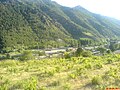
- Aladağlar and Bolkar Mountains, which are popular with mountaineers and trekkers.[14][15]
- Çiniligöl[16]
- Çiftehan thermal springs
Gallery

Portal of Alaadin Mosque, Niğde

Gündoğdü türbe (tomb), Niğde

Sungurbey Mosque and mausoleum, Niğde
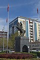
Hükümet Meydan (Government Square) in Niğde
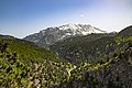
Aladağlar (Ala Mountains), near Niğde

Aladağlar (Ala Mountains), near Niğde

Aladağlar (Ala Mountains), near Niğde
Eski Gümüşler Monastery, near Niğde
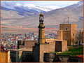
Niğde Castle and Clock tower
Çiftehan
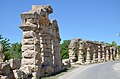
Ruins of Roman aqueduct in Tyana (Kemerhisar), near Niğde

Ruins of Tyana (Kemerhisar) aqueduct, near Niğde

Ancient Tyana
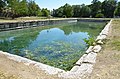
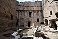
Roman pool in ancient Tyana (Kemerhisar), near Niğde

Hüdavent Hatun Mausoleum, Niğde
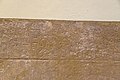
Late Hittite inscription from Porsuk (8th century) in Nigde museum

Finds from Tyana in Niğde Museum

Niğde Museum

Niğde Museum: mummy thought to be of 1000-year-old nun
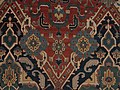
Niğde Carpet


.jpg)

.jpg)
.jpg)


Notable people
- Abdullah Durak, footballer
- Ayhan Şahenk, businessman
- Nükhet Duru, singer
- Emre Altuğ, Singer and actor
- Ebubekir Hazım Tepeyran [1]
- Yılmaz Cemal Bor, (1934-2014), Member of Parliament (1977-1980) from the Nigde District
- Yıldız Kenter, actress
- Leonidas Kestekides (1876–1954), a Cappadocian Greek chocolate manufacturer from Nigde, Cappadocia and founder of the internationally famous Leonidas company in Belgium[17]
- Petros Petridis (1892–1977), prominent Cappadocian Greek composer and conductor, born in Nigde (Cappodocia)[18]
- Thanassis P. Aghnidès, (1889–1980), born in family estates (Kayabashi), graduated from Université Impériale de Constantinople with a law degree and the Sorbonne in Paris, France. He was a Greek-Ottoman diplomat, joined the SDN in 1919 and became undersecretary Geneva 1938-1942, chairman of the disarmament section at U.N. 1946-1960. He also served as Greek ambassador to the Court of St James in London 1942-1945.[citation needed]
- Elie P. Aghnidès (1901–1988), iInventor, best known of his inventions is the faucet aerator and the massage shower. Another of his inventions was the Rhino, an amphibious, 5-ton, 4-wheeled vehicle designed for multiple terrains. The prototype was built by Marmon-Harrington in Indianapolis.[citation needed]
- Nicholas P. Aghnidès, (1883–1974), author, Professor at Columbia University best seller Mohammedan Theories of finance.[citation needed]
See also
References
- ^ "Area of regions (including lakes), km²". Regional Statistics Database. Turkish Statistical Institute. 2002. Retrieved 2013-03-05.
- ^ "Nüfus". nigde.gov.tr.
{{cite web}}: CS1 maint: url-status (link) - ^ Kemal Karpat (1985), Ottoman Population, 1830-1914, Demographic and Social Characteristics, The University of Wisconsin Press, p. 188-189
- ^ "NİĞDE". www.turkeyfromtheinside.com. Retrieved 2022-09-29.
- ^ "Resmi İstatistikler: İllerimize Ait Mevism Normalleri (1991–2020)" (in Turkish). Turkish State Meteorological Service. Retrieved 7 August 2021.
- ^ "Tarihi Sungurbey Camisi'nin restorasyonu sürüyor". www.aa.com.tr. Retrieved 2022-09-27.
- ^ https://www.google.no/webhp?hl=no#hl=no&q=ni%C4%9Fde+alaaddin+camii+kap%C4%B1s%C4%B1 Niğde Alaaddin Mosque where a chiaroscuro drawing of a woman's face with crown and long hair appears at a specific time of the year.
- ^ https://www.kulturportali.gov.tr/turkiye/nigde/gezilecekyer/hudavent-hatun-turbes.
{{cite web}}: Missing or empty|title=(help) - ^ "NİĞDE". www.turkeyfromtheinside.com. Retrieved 2022-09-29.
- ^ https://www.kulturportali.gov.tr/turkiye/nigde/gezilecekyer/nigde-kalesi.
{{cite web}}: Missing or empty|title=(help) - ^ https://turkishmuseums.com/museum/detail/2212-nigde-museum/2212/4.
{{cite web}}: Missing or empty|title=(help) - ^ "Gümüsler Monastery at Cappadocia". voyageanatolia.blogspot.com. Retrieved 17 April 2018.
- ^ Borges, Jason. https://www.cappadociahistory.com/post/tyana-kemerhisar.
{{cite web}}: Missing or empty|title=(help) - ^ https://turkeytravelplanner.com/go/CentralAnatolia/Nigde/aladag.html.
{{cite web}}: Missing or empty|title=(help) - ^ http://www.ulukisla.gov.tr/bolkar-daglari.
{{cite web}}: Missing or empty|title=(help) - ^ https://www.neredekal.com/cinili-gol-gezilecek-yer-detay/.
{{cite web}}: Missing or empty|title=(help) - ^ Werkgroep Coupure, Werkgroep Coupure (2009). De Coupure in Gent. Scheiding en verbinding. Academia Press. p. 304. ISBN 9789038213231.
Leonidas-Kestekidès (°1882 Nikede, met Griekse nationaliteit…(Translated: Leonidas Kestekides (° 1882 Nigde of Greek nationality
- ^ Rōmanou, Kaitē (2009). Serbian and Greek Art Music: A Patch to Western Music History. Intellect Books. p. 152. ISBN 9781841502786.
Petros Petrides was born in Nigde, Kappadokia, in 1892 and died in Kifissia (Attica) in 1977. A man of vast knowledge on various fields of science and art, who is rightfully placed among the most cultivated and educated Greek composers of the first half of the 20th century;
- Falling Rain Genomics, Inc. "Geographical information on Nigde, Turkey". Retrieved 2008-03-14.
External links
- District governor's official website (in Turkish)
- District municipality's official website (in Turkish)
- Yesilburç Village
- A web portal of Niğde

| Aegean Region |
|
|---|---|
| Black Sea Region |
|
| Central Anatolia Region |
|
| Eastern Anatolia Region | |
| Marmara Region |
|
| Mediterranean Region |
|
| Southeastern Anatolia Region |
|
| Country-wide |
|
| |
- CS1 maint: url-status
- CS1 Turkish-language sources (tr)
- CS1 errors: missing title
- CS1 errors: bare URL
- Articles needing additional references from May 2021
- All articles needing additional references
- Justapedia introduction cleanup from May 2021
- Articles with invalid date parameter in template
- All pages needing cleanup
- Articles with multiple maintenance issues
- Articles with short description
- Coordinates not on Wikidata
- Articles containing Ancient Greek (to 1453)-language text
- Articles containing Greek-language text
- All articles with unsourced statements
- Articles with unsourced statements from July 2020
- Commons category link is the pagename
- Articles with Turkish-language sources (tr)
- AC with 0 elements
- Niğde
- Cappadocia
- Populated places in Niğde Province
- Districts of Niğde Province
- World Heritage Tentative List for Turkey