Natural Earth projection
Jump to navigation
Jump to search
This article is missing information about distortion, software support and the polynomial. (February 2017) |

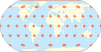
The natural Earth projection with Tissot's indicatrix of deformation
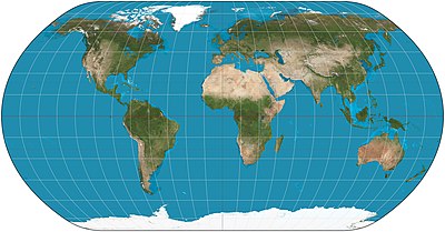
The Natural Earth projection is a pseudocylindrical map projection designed by Tom Patterson and introduced in 2012. It is neither conformal nor equal-area, but a compromise between the two.
It was designed in Flex Projector, a specialized software application that offers a graphical approach for the creation of new projections.[1][2]
Definition
The natural Earth is defined by the following formulas:
- ,
where
- and are the Cartesian coordinates;
- is the longitude from the central meridian in radians;
- is the latitude in radians;
- is the length of the parallel at latitude ;
- is the distance of the parallel from the equator at latitude .
and are given as polynomials:[3]
In the original definition of the projection, planar coordinates were lineally interpolated from a table of 19 latitudes and then multiplied by other factors. The authors of the projection later provided a polynomial representation that closely matches the original but improves smoothness at the "corners".[1]
See also
References
- ^ a b Šavrič, Bojan; Jenny, Bernhard; Patterson, Tom; Petrovič, Dušan; Hurni, Lorenz (February 17, 2012). "A Polynomial Equation for the Natural Earth Projection" (PDF). Oregon State University. Archived from the original (PDF) on 2016-03-03. Retrieved January 24, 2020.
- ^ Jenny, Bernhard; Patterson, Tom; Hurni, Lorenz (2008). "Flex Projector–Interactive Software for Designing World Map Projections". Cartographic perspectives. Retrieved January 24, 2020.
- ^ "Natural Earth Projection: Home". www.shadedrelief.com. Archived from the original on 2012-04-07. Retrieved 2017-02-12.
It was originally designed in Flex Projector using graphical methods and now exists as a polynomial version.


![{\displaystyle x\in [-2.73539,2.73539]}](https://wikimedia.org/api/rest_v1/media/math/render/svg/da10aaca58ebe3f20e7c5205770cd130de934918)
![{\displaystyle y\in [-1.42239,1.42239]}](https://wikimedia.org/api/rest_v1/media/math/render/svg/db4bd1408c5baeb1fd8e9c1208f4b529bc966114)
![{\displaystyle \lambda \in [-\pi ,\pi ]}](https://wikimedia.org/api/rest_v1/media/math/render/svg/ae855a95e654fa4dcc970b4ad667f884290b130d)
![{\displaystyle \varphi \in [-\pi /2,\pi /2]}](https://wikimedia.org/api/rest_v1/media/math/render/svg/86aee5943693238957c5971fdf837cf0c3dd67ee)


