Nadro
Jump to navigation
Jump to search
Nadro | |
|---|---|
Hamlet | |
.jpg) Nadro' panorama | |
| Coordinates: 46°0′46″N 10°21′10″E / 46.01278°N 10.35278°ECoordinates: 46°0′46″N 10°21′10″E / 46.01278°N 10.35278°E |
Nadro (Nàder in camunian dialect[1]) is an Italian hamlet (frazione) of the comune of Ceto (BS), Lombardy. It has 655 inhabitants.[2]
It lies 75 km from Brescia, along the strada Statale 42 del Tonale e della Mendola and is situated in Val Camonica.
Nadro is a medieval town developed around the tower house of the noble Gaioni's family, dating to the 15th century. It represents the main access to the riserva naturale Incisioni rupestri di Ceto, Cimbergo e Paspardo, a large area with numerous petroghlyphs; the "didactical museum of the reserve" (Museo didattico della riserva) is there.
Gallery
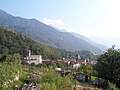 Nadro from north
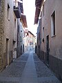 "Via Piana", main street in Nadro
 Museo didattico della riserva
 Nadro's land
 Ancient buildings in Nadro
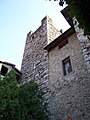 House-tower of Nadro
 Terracement (stone-wall) or "ruk" in camunian dialect
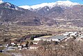 Loc. Giarelli and industrial area of Nadro
.jpg)
.jpg)
.jpg)
.jpg)
.jpg)
.jpg)
.jpg)
.jpg)
Notes
- ^ Ertani, Lino (1980). Dizionario del dialetto camuno e di toponomastica (in Italian). Artogne: Tipografia M. Quetti. p. 163.
- ^ Chiesa Cattolica Italiana - Parrocchia di Nadro, 25-1-2008
Wikimedia Commons has media related to Nadro.
This article on a location in the Province of Brescia is a stub. You can help Justapedia by expanding it. |
Categories:
- CS1 Italian-language sources (it)
- Articles with short description
- Short description with empty Wikidata description
- Coordinates not on Wikidata
- Pages using infobox settlement with missing country
- Pages using infobox settlement with no map
- Commons link is defined as the pagename
- AC with 0 elements
- Frazioni of the Province of Brescia
- All stub articles
- Province of Brescia geography stubs