Muav Limestone
| Muav Limestone | |
|---|---|
| Stratigraphic range: Middle Cambrian[1][2] | |
 representative sequence of Redwall Limestone, Temple Butte Formation, and Muav Limestone, in Grand Canyon | |
| Type | Geological formation |
| Unit of | Tonto Group[3] |
| Underlies | either the Frenchman Mountain Dolostone (Cambrian) or Redwall Limestone (Mississippian). Locally underlies Temple Butte Formation (Devonian) that fills narrow paleovalleys cut into the Muav Limestone. |
| Overlies | Bright Angel Shale |
| Thickness | 650 feet (200 m), at maximum |
| Lithology | |
| Primary | limestone and dolomite |
| Other | calcareous mudstone |
| Location | |
| Region | Northern Arizona (Grand Canyon), central Arizona, southeast California, southern Nevada, and southeast Utah |
| Country | United States of America |
| Type section | |
| Named for | Muav Canyon, north side of Colorado River[4] |
| Named by | Noble (1914)[4] |
The Cambrian Muav Limestone is a geologic unit within the 5-member Tonto Group. It is about 650 feet (198 m) thick at its maximum. It is a resistant cliff-forming unit. The Muav consists of dark to light-gray, brown, and orange red limestone with dolomite and calcareous mudstone.[5][3] The Muav Limestone is overlain in the western Grand Canyon by the late Cambrian Frenchman Mountain Dolostone. Eastward, the Frenchman Mountain Dolostone pinches out and the Mississippian Redwall Limestone, which forms prominent vertical cliffs, directly lies upon the Muav Limestone. The Devonian Temple Butte Formation fill deep paleovalleys that have been cut through the Frenchman Mountain Dolostone and into the Muav Limestone.[3]
The Muav is in part younger than, and in-part grades into, the Bright Angel Shale, which is less erosion resistant and is categorized as a slope-forming unit. The Muav is about 350 feet thick in the east and reaches about 600 feet thick in the western part of its exposure area in the Grand Canyon.[6] The two units lie above the erosion-resistant cliff-forming Tapeats Sandstone.
In the eastern canyon, the Tapeats Sandstone creates the extremely horizontal Tonto Platform. In west Grand Canyon, the north-south Toroweap Fault is the west perimeter of the Tonto Platform, and west Grand Canyon is dominated by the erosion resistant unit of the Esplanade Sandstone. The Tonto Trail is a mostly horizontal trail on the south side of Granite Gorge, on the Tonto Platform.
The Tonto Group units were deposited on an ancient erosion surface (angular unconformity) on the Vishnu Basement Rocks. The Vishnu sequence has a dip of about 45 degrees. As this long-timeframe unconformity represents about 1,000 million years (1.0 billion years) of non–deposition, tectonic activity and erosion, on the Vishnu Basement Rocks, is called the Great Unconformity.
Beyond the Grand Canyon area the Muav occurs in southern Utah, southern Nevada and southern California. In the California occurrence it is known as the Muav Marble.[6]
Geologic sequence
The units of the Tonto Group:[3]
- 5 – Frenchman Mountain Dolostone
- 4 – Muav Limestone
- 3 – Bright Angel Shale
- 2 – Tapeats Sandstone (start of transgression series)
- 1 – Sixtymile Formation
Gallery – Muav Limestone
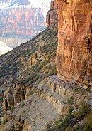
Muav Limestone cliff example, below Redwall Limestone cliff, on the North Kaibab Trail (closeup photos, often show purple erosion debris)(expandable photo)

(view due-north, northeast, from Bright Angel Trail, (South Rim section) – View of south-draining Bright Angel Canyon, containing in its lowest section with the Tapeats Sandstone, upon the Granite Gorge, the cliffs of gray-brown Muav Limestone (25% at base of Redwall Limestone), laid upon the slope-forming & greenish Bright Angel Shale. (The trail also descends/ascends through units on the South Rim, at near photo view.)

View to Sumner Butte, Redwall Limestone peak & vertical cliff, sitting on Muav Limestone


See also
References
- ^ Rose, E. (2006) "Nonmarine aspects of the Cambrian Tonto Group of the Grand Canyon, USA, and broader implications". Palaeoworld. 15:223–241.
- ^ Rose, E (2011) Modification of the nomenclature and a revised deposition model for the Cambrian Tonto Group of the Grand Canyon, Arizona. in JS Hollingsworth, FA Sundberg, and JR Foster, eds., pp. 77–98, Cambrian Stratigraphy and Paleontology of Northern Arizona and Southern Nevada: Museum of Northern Arizona Bulletin 67, 321 p.
- ^ a b c d Connors, T.B., Tweet, J.S., and Santucci, V.L., 2020. Stratigraphy of Grand Canyon National Park. In: Santucci, V.L., Tweet, J.S., ed., pp. 54–74, Grand Canyon National Park: Centennial Paleontological Resource Inventory (Non-sensitive Version) . Natural Resource Report NPS/GRCA/NRR—2020/2103. National Park Service, Fort Collins, Colorado, 603 pp.
- ^ a b Lua error in Module:Cite_Q at line 13: attempt to index a nil value.
- ^ Karlstrom, K.E., Mohr, M.T., Schmitz, M.D., Sundberg, F.A., Rowland, S.M., Blakey, R., Foster, J.R., Crossey, L.J., Dehler, C.M. and Hagadorn, J.W., 2020. Redefining the Tonto Group of Grand Canyon and recalibrating the Cambrian time scale. Geology, 48(5), pp. 425–430.
- ^ a b Anonymous (2006d) Muav Limestone Archived 2015-11-22 at the Wayback Machine, Stratigraphy of the Parks of the Colorado Plateau Archived 2010-12-24 at the Wayback Machine. U.S. Geological Survey, Reston, Virginia.
Further reading
- Blakey, and Ranney, 2008. Ancient Landscapes of the Colorado Plateau, Ron Blakey, Wayne Ranney, c 2008, Grand Canyon Association (publisher), 176 pages, with Appendix, Glossary, Index. Contains approximately 75 shaded topographic maps, for geology, etc., with 54 (23 pairs, (46)) for Colorado Plateau specifically; others are global, or North American.
- Arizona Geological Society, Arizona Geological Survey, c. 1998 (etc.) Geologic Highway Map of Arizona. Contains geologic map, Arizona Shaded Relief Map, Geologic Cross Sections, Shaded Relief Map of Arizona, Geologic Map of the Grand Canyon in the Vicinity of the South Rim Visitor Center, etc.
External links
- Abbot, W, (2001) Revisiting the Grand Canyon – Through the Eyes of Seismic Sequence Stratigraphy. Search and Discovery Article # 40018, America Association of Petroleum Geologists, Tulsa, Oklahoma.
- Anonymous (2006a) Tonto Group, Stratigraphy of the Parks of the Colorado Plateau. U.S. Geological Survey, Reston, Virginia.
- Anonymous (2006b) Tapeats Sandstone, Stratigraphy of the Parks of the Colorado Plateau. U.S. Geological Survey, Reston, Virginia.
- Anonymous (2006c) Bright Angel Shale, Stratigraphy of the Parks of the Colorado Plateau. U.S. Geological Survey, Reston, Virginia.
- Anonymous (2006d) Muav Limestone, Stratigraphy of the Parks of the Colorado Plateau. U.S. Geological Survey, Reston, Virginia.
- Hartman, J. H. (2001) Muav Limestone, Grand Canyon National Park, Coconino County, Arizona. GeoDIL, A Geoscience Digital Image Library, University of North Dakota, Grand Forks, North Dakota.
- Mathis, A., and C. Bowman (2007) The Grand Age of Rocks: The Numeric Ages for Rocks Exposed within Grand Canyon, Grand Canyon National Park, Arizona, National Park Service, Grand Canyon National Park, Arizona.
- Noble, L. F. (1923a) Unconformity between Temple Butte limestone and Muav limestone, Coconino County, Arizona, Plate 22-A. U.S. Geological Survey Photographic Library, Reston, Virginia.
- Noble, L. F. (1923b) Unconformity between Temple Butte limestone and Muav limestone, Coconino County, Arizona, Plate 22-B. U.S. Geological Survey Photographic Library, Reston, Virginia.
- Noble, L. F. (1923c) Unconformity between Temple Butte limestone and Muav limestone, Coconino County, Arizona, Plate 23-A. U.S. Geological Survey Photographic Library, Reston, Virginia.
- Rowland, S. (nda) Frenchman Mountain and the Great Unconformity. Department of Geoscience, University of Nevada, Las Vegas, Nevada.
- Rowland, S. (ndb) Geologic Map of Frenchman Mountain. Department of Geoscience, University of Nevada, Las Vegas, Nevada.
- Stamm, N. (2013) Geologic Unit Muav (Limestone), National Geologic Database. U.S. Geological Survey, Reston, Virginia.
- Timmons, S. S. (2003) Learning to Read the Pages of a Book (Grand Canyon Geology Training Manual), National Park Service, Grand Canyon National Park, Arizona.
- Pages with script errors
- Webarchive template wayback links
- Articles with short description
- Short description with empty Wikidata description
- Commons category link is defined as the pagename
- Limestone formations of the United States
- Natural history of the Grand Canyon
- Geologic formations of Arizona
- Geologic formations of Nevada
- Cambrian Arizona
- Cambrian Nevada
- Cambrian System of North America