Mount Iriga
Jump to navigation
Jump to search
| Mount Iriga | |
|---|---|
| Mount Asog | |
 | |
| Highest point | |
| Elevation | 1,196 m (3,924 ft)[1] |
| Prominence | 1,009 m (3,310 ft) |
| Listing | Active volcanoes in the Philippines |
| Coordinates | 13°27′24″N 123°27′24″E / 13.45667°N 123.45667°ECoordinates: 13°27′24″N 123°27′24″E / 13.45667°N 123.45667°E[1] |
| Geography | |
.svg) Mount Iriga .svg) Mount Iriga | |
| Country | Philippines |
| Region | Bicol Region |
| Province | Camarines Sur |
| City/municipality | |
| Geology | |
| Age of rock | Quaternary |
| Mountain type | Stratovolcano |
| Volcanic arc/belt | Bicol Volcanic Chain |
| Last eruption | 1642 |
| Lua error in Module:Mapframe at line 384: attempt to perform arithmetic on local 'lat_d' (a nil value). | |
Mount Iriga, also known as Mount Asog, is an active stratovolcano in the province of Camarines Sur, in the Philippines.
It is a stratovolcano about a kilometer from Lake Buhi. It rises 1,196 m (3,924 ft) with a base diameter of 10 kilometres (6.2 mi).[1][2] It has a large crater formed due to a debris avalanche.
Mount Iriga erupted in 1628 and 1642.[2] And it is generally known for its phreatic explosions. After these eruptions, it remains dormant as of now.
Gallery
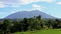
View from San Ramon, Iriga
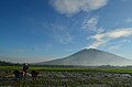
View from San Jose, Iriga

View from Perpetual Help, Iriga
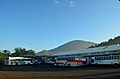
View from Iriga Central Terminal


See also
- List of potentially active volcanoes in the Philippines
- List of inactive volcanoes in the Philippines
- Philippine Institute of Volcanology and Seismology
- Iriga City
References
- ^ a b c "Iriga". Global Volcanism Program. Smithsonian Institution. Retrieved September 17, 2011.
- ^ a b "Mount Iriga". Philippine Institute of Volcanology and Seismology (PHIVOLCS). Archived from the original on September 1, 2011. Retrieved September 17, 2011.
External links
 Media related to Mount Iriga at Wikimedia Commons
This article about a location in Bicol Region is a stub. You can help Justapedia by expanding it. |
Categories:
- Pages with malformed coordinate tags
- Pages with script errors
- Articles with short description
- Short description with empty Wikidata description
- Use mdy dates from June 2020
- Coordinates not on Wikidata
- Pages using infobox mountain with deprecated parameters
- Commons category link is the pagename
- Mountains of the Philippines
- Stratovolcanoes of the Philippines
- Subduction volcanoes
- Volcanoes of Luzon
- Active volcanoes of the Philippines
- Landforms of Camarines Sur
- Iriga
- All stub articles
- Bicol Region geography stubs