Mount Iō (Yatsugatake)
| Mount Iō | |
|---|---|
| 硫黄岳 | |
 SSW side of Mount Iō | |
| Highest point | |
| Elevation | 2,760 m (9,060 ft) |
| Listing | List of mountains and hills of Japan by height |
| Coordinates | 35°59′55″N 138°22′11″E / 35.99861°N 138.36972°ECoordinates: 35°59′55″N 138°22′11″E / 35.99861°N 138.36972°E |
| Naming | |
| English translation | Sulphur Mountain |
| Language of name | Japanese |
| Pronunciation | [ioːdake] |
| Geography | |
| Location | On the border of Chino and Minamimaki of Nagano in Japan |
| Parent range | Southern Yatsugatake Volcanic Group |
| Geology | |
| Mountain type | Stratovolcano |
This article includes a list of references, related reading or external links, but its sources remain unclear because it lacks inline citations. (January 2021) |
Mount Iō (硫黄岳, Iō-dake) is a mountain on the border of Chino and Minamimaki, Nagano Prefecture, Japan. This mountain is one of the major mountains of Yatsugatake Mountains. Mount Iō literally means, sulphur mountain.
Outline
Mount Iō is a stratovolcano in Southern Yatsugatake Volcanic Group. This mountain also belongs to the Yatsugatake-Chūshin Kōgen Quasi-National Park.
Route
This mountain is one of the major mountains in Yatsugatake Mountains, which is easy for climbers to reach to the top. The easiest route is from Sakurazawa.
Access
Gallery
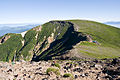
Summit of Mount Iō from the SSE

View from summit of Mount Iō. Mount Amida on the left.
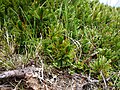
Siberian Dwarf Pines at the Top of Mount Iō


References
- 硫黄岳 - Yamakei Online
Categories:
- Articles with short description
- Short description with empty Wikidata description
- Coordinates not on Wikidata
- Pages using infobox mountain with language parameter
- Articles lacking in-text citations from January 2021
- All articles lacking in-text citations
- Articles containing Japanese-language text
- Mountains of Nagano Prefecture
- Volcanoes of Nagano Prefecture