Mount Airy, New Jersey
(Redirected from Mount Airy Historic District (Lambertville, New Jersey))
Mount Airy, New Jersey | |
|---|---|
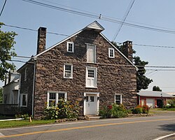
 Historic storehouse in Mount Airy | |
| Coordinates: 40°23′55″N 74°54′26″W / 40.39861°N 74.90722°WCoordinates: 40°23′55″N 74°54′26″W / 40.39861°N 74.90722°W | |
| Country | |
| State | |
| County | Hunterdon |
| Township | West Amwell |
| Elevation | 259 ft (79 m) |
| GNIS feature ID | 878514[1] |
Mount Airy Historic District | |
| NRHP reference No. | 89001943[2] |
|---|---|
| Added to NRHP | November 13, 1989 |
Mount Airy is an unincorporated community located within West Amwell Township in Hunterdon County, New Jersey, United States.[3]
History
A mill existed on the Alexauken Creek east of Mount Airy prior to the Revolution. By 1881, Mount Airy had a school, store, church, wagon and blacksmith shop, grist-mill, and about 12 dwellings. Prior to 1881 a hotel was located at the settlement.[4]
References
- ^ a b "Mount Airy". Geographic Names Information System. United States Geological Survey, United States Department of the Interior.
- ^ "National Register Information System". National Register of Historic Places. National Park Service. March 13, 2009.
- ^ Locality Search, State of New Jersey. Accessed January 31, 2015.
- ^ Snell, James P. (1881). History of Hunterdon and Somerset Counties, New Jersey. Everts & Peck. pp. 346, 349.
Wikimedia Commons has media related to Mount Airy, New Jersey.
Categories:
- Articles using NRISref without a reference number
- Articles with short description
- Coordinates not on Wikidata
- NRHP infobox with nocat
- Commons category link is the pagename
- West Amwell Township, New Jersey
- Unincorporated communities in Hunterdon County, New Jersey
- Unincorporated communities in New Jersey
- National Register of Historic Places in Hunterdon County, New Jersey
- All stub articles
- New Jersey Registered Historic Place stubs
- Hunterdon County, New Jersey geography stubs


