Milíře
Milíře | |
|---|---|
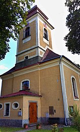
 General view | |
| Coordinates: 49°47′47″N 12°33′2″E / 49.79639°N 12.55056°ECoordinates: 49°47′47″N 12°33′2″E / 49.79639°N 12.55056°E | |
| Country | |
| Region | Plzeň |
| District | Tachov |
| First mentioned | 1669 |
| Area | |
| • Total | 14.89 km2 (5.75 sq mi) |
| Elevation | 635 m (2,083 ft) |
| Population (2022-01-01)[1] | |
| • Total | 245 |
| • Density | 16/km2 (43/sq mi) |
| Time zone | UTC+1 (CET) |
| • Summer (DST) | UTC+2 (CEST) |
| Postal code | 347 01 |
| Website | www |
Milíře (German: Brand, Tachauer Brand, Albersdörfer Brand) is a municipality and village in Tachov District in the Plzeň Region of the Czech Republic. It has about 200 inhabitants.
Administrative parts
The village of Zadní Milíře is an administrative part of Milíře.
Etyomology
The name literally means "charcoal piles".
Geography
Milíře is located about 6 km (4 mi) west of Tachov and 58 km (36 mi) west of Plzeň. It lies in the Upper Palatinate Forest. The highest point is a contour line at 750 m (2,460 ft) above sea level.
History
The first written mention of Milíře is from 1669. Zadní Milíře was first mentioned in 1778.[2]
In 1946, most German-speaking inhabitants were expelled. After the war, the area was only partly repopulated.
Sights
The landmark of Milíře is the Church of Saints Peter and Paul. It was built in the Neoclassical style in 1814–1816. Together with the rectory, school, memorial cross and World War I memorial, it forms a valuable set of historical buildings.[3]
References
- ^ "Population of Municipalities – 1 January 2022". Czech Statistical Office. 2022-04-29.
- ^ "Historie" (in Czech). Obec Milíře. Retrieved 2022-09-21.
- ^ "Kostel sv. Petra a Pavla" (in Czech). National Heritage Institute. Retrieved 2022-09-21.


