Maupiti Airport
Jump to navigation
Jump to search
Maupiti Airport | |||||||||||
|---|---|---|---|---|---|---|---|---|---|---|---|
 | |||||||||||
| Summary | |||||||||||
| Airport type | Public | ||||||||||
| Operator | Government | ||||||||||
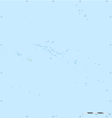
| Location | Maupiti, Leeward Islands, French Polynesia | ||||||||||
| Elevation AMSL | 15 ft / 5 m | ||||||||||
| Coordinates | 16°25′35″S 152°14′36″W / 16.42639°S 152.24333°WCoordinates: 16°25′35″S 152°14′36″W / 16.42639°S 152.24333°W | ||||||||||
| Map | |||||||||||
| Runways | |||||||||||
| |||||||||||
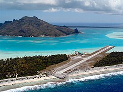
Maupiti Airport (IATA: MAU, ICAO: NTTP) is an airport on Maupiti, one of the Leeward Islands in French Polynesia. The airport is 2 kilometres (1.1 NM) north of the village.[1][2]
Airlines and destinations
| Airlines | Destinations |
|---|---|
| Air Tahiti | Bora Bora, Papeete, Raiatea |
References
- ^ a b NTTP – MAUPITI. AIP from French Service d'information aéronautique, effective 13 June 2024.
- ^ a b Airport information for NTTP from DAFIF (effective October 2006)
- ^ Airport information for MAU at Great Circle Mapper. Source: DAFIF (effective October 2006).
External links
